
|
|
Mountain/Rock |
|---|---|
|
|
49.01023°N / 113.94336°W |
|
|
Hiking |
|
|
Summer |
|
|
7926 ft / 2416 m |
|
|
Overview
Mount Richards is a peak located in Waterton Lakes National Park in the Canadian Province of Alberta. This mountain is one of the southernmost peaks in the park placing it very near the Canada/USA boundary. Looking on a topo map one will notice that it is located basically directly west of Mt. Boswell but on the opposite side of Upper Waterton Lake – Boswell sits next to the lake on its east side, and Richards sits next to the lake on its west side.This mountain is typically accessed from Bertha Lake which lies at the base of a cirque formed by Mount Richards, Mount Alderson, and Bertha Peak. Click here to view a map. Mount Richards lies at the south end of Bertha Lake.
Mount Richards is visible from the Waterton Townsite area, simply look south along Upper Waterton Lake, and you will notice it on the right.
The true summit of Mount Richards, from the townsite view, is hidden behind one of it's many false summits.
Named for Admiral Richards of the British Boundary Commission which delineated the border from the Pacific to the Rockies. It has also been called Sleeping Indian Mountain.

Above photo belongs to and is displayed from hikingwithbarry.com
Getting There
Mount Richards is located in Waterton Lakes National Park in Alberta, Canada. This Park is situated 270 km (162 miles) south of Calgary, Alberta, 43 km (27 miles) west of Cardston, Alberta, and about 80 km (48 miles) from the St. Mary entrance to Glacier National Park, Montana. When driving to Waterton Lakes National Park it can only be accessed from its eastern side.From Calgary take Highway 2 south to Fort Macleod, then west on Highway 3 to Pincher Creek, then south again on Highway 6. The drive requires about three hours.
From Cardston take Highway 5 west, through the village of Mountain View. The drive is less than 40 minutes.
From Glacier National Park, Montana, take the Chief Mountain International Highway (closed in the winter). From the St. Mary entrance of GNP it is approximately a 1 hour drive. In the winter take Montana Highway 89 to Alberta Highway 2 to Cardston, then Highway 5 to Waterton.
Once you pass through the toll both on Highway 5 continue into the townsite heading for Cameron Falls on Evergreen drive. Pass the falls and watch for a gravel parking area a block down the road on the right.
Click here for a map.
Route
Andrew W. Nugara in his book "More Scrambles in the Canadian Rockies: 2nd Edition" suggests accessing the NE ridge of Mount Richards, from Bertha Lake, and following it in a south west direction to the summit. He warns that this scramble "packs a real punch", and he suggest a car to car time of 14 hours. The ridge involves exposed scrambling, and the crossing of multiple false peaks. To gain the NE ridge, Nugara instructs peakbaggers to walk slightly around the east side of Bertha Lake, "for about 5 minutes"(and not to far from the north east end) until an obvious ramp paralleling the tree line becomes visible on the left. He says to follow the ramp aiming for the point on the north ridge where the tree line ends. Once on the ridge he says it takes several hours to finally reach the peak, and along the way rock bands have to be skirted and elevation lost and regained. From the top he says you can choose to either reverse your steps, or drop down the south side eventually encountering the boundary trail and then following that back to where it connects with the Bertha Lake trail. Warning the boundary creek trail is actually in the USA, so bring your passport with you if you choice to descend the south side. Nugara’s book can be found for free on Google Books.Alternatively, the late Rick Collier suggests starting at the south west end of Bertha Lake, thereby gaining the NE ridge further to the SW, rather than walking the full NE ridge. To do so make your way to the south end of the lake and headed up an obvious drainage at that point. The drainage will take you up and mostly east (but slightly south) until it gains the NE ridge. Once on the ridge turn right and make your way to the summit. The descent would be the reverse or via the boundary creek trail as suggested above. If you are willing to pay for it you can read Collier's trip report here.
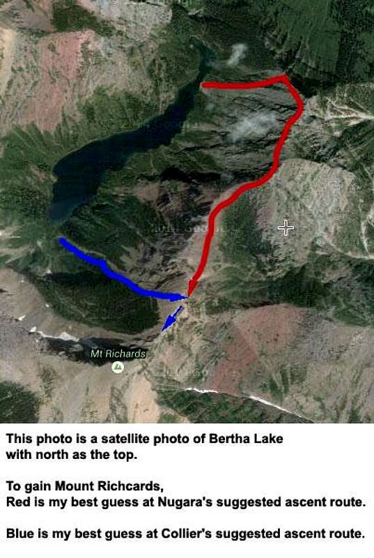
Both routes obviously involve a lot of scrambling and route finding. The Collier route, to me, appears to be more functional.
Both ascent routes mentioned above start by first getting to Bertha Lake. The trailhead for Bertha Lake begins at the southwest corner of Waterton Village on Evergreen Drive, a short distance south of Cameron Falls, it’s about 5.5 km to the lake, and should require under 1.5 hours. At 1.5 km the trail to Lower Bertha Falls branches left to a viewpoint overlooking Upper Waterton Lake with an excellent view south with Mount Richards dominating the view.
Compare this description to the two routes mentioned above.
Camping
The closest conventional campground is the Waterton Townsite campground. The closest backcountry site is at Bertha Lake which you pass on the ascent. To learn more visit http://www.pc.gc.ca/eng/pn-np/ab/waterton/visit/visit5.aspx.An alternative to camping is one of the many motels in the Townsite. If you want something historic try the pricey, but famous, Prince of Wales hotel. See a photo of Mount Richards looking southwest from the Prince of Wales Hotel.