
|
|
Mountain/Rock |
|---|---|
|
|
49.13481°N / 114.07946°W |
|
|
Hiking, Mountaineering, Trad Climbing |
|
|
Spring, Summer, Fall, Winter |
|
|
8701 ft / 2652 m |
|
|
Overview
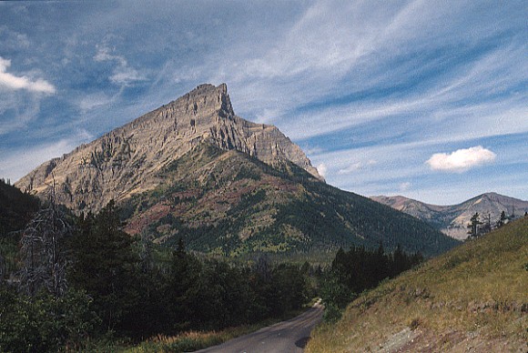
(The above image belongs to mtnmouse.com)
There are several different numbers floating around for this mountains elevation, it has been listed as low as 2652 m, and as high as 2698 m. At the time of this writing a detailed on-line topo map of the area could not be found, however a terrain map on Acme Mapper 2.0 seems to show the elevation to be less than 2660 m (thus confirming the 2652 m elevation "officially" used for this page). An approximate 2660 m elevation marker is also used by the Waterton Lakes National Park map found on the Parks Canada website where both Mount Anderson and Mount Alderson are labeled at that elevation. At 2910 m Mount Blakiston is the tallest in the Park, and Mount Anderson is not far behind.
Mount Anderson resides in the North West corner of this 505 sq km (195 sq. mi) park, offering breath taking, panoramic, views in all directions. To the east is the infamous Red Rock Canyon. To the north, one may glimpse Goat Lake and the surrounding peaks. To the south are Mount Hawkins and Mount Blakiston . To the west, along the same ridge line are Lost Mountain and Mount Bauerman.
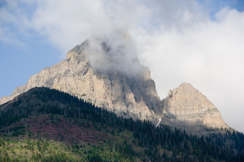 The view here is of the "false" summit, the "true" summit is behind and slightly left of this one. (Above image is displayed from and belongs to barbaramartin.blogspot.com) |
An interesting geological feature of Mount Anderson is its Purcell Sill. "When viewed from the Red Rock Canyon road, the sharp summits of Anderson peak feature a black, horizontal stripe. This is the Purcell Sill, created when magma (molten rock) was injected under tremendous pressures between layers of sedimentary rock near the top of the Siyeh formation. The magma then slowly cooled to become diabase, the coarse grained equivalent of basalt. Igneous rock such as this is very rare in the Canadian Rockies." [Ben Gadd]
Mount Anderson is one of the peaks of the Clark Range. The Clark Range forms part of the Continental Divide and also the boundary between the Canadian provinces of Alberta and British Columbia. A small portion of this range extends into the far northwestern section of Glacier National Park, Montana, USA. The range is named for Captain William Clark of the Lewis and Clark Expedition.
The home of Mount Anderson, together with neighboring Glacier National Park, in the US state of Montana, form the world's first International Peace Park established in 1932. UNESCO has identified this area as a World Heritage Site making the joint peace park a worldwide treasure.
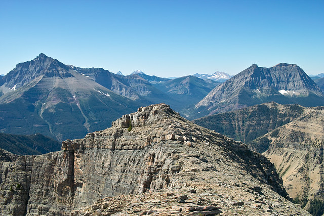  (Above image is displayed from Flickr and belongs to AlbertaScrambler) |
In the picture above Mount Blakiston is on the left and Mount Anderson is on the right. This is a view of the east aspects as seen looking west from Mt Galaway. The true summit of Mount Anderson is on the right side. From this view Lost Mountain and Mount Bauerman are behind Mount Anderson.
Getting There
Mount Anderson is located in Waterton Lakes National Park in Alberta, Canada. This Park is situated 270 km (162 miles) south of Calgary, Alberta, 43 km (27 miles) west of Cardston, Alberta, and about 80 km (48 miles) from the St. Mary entrance to Glacier National Park, Montana. When driving to Waterton Lakes National Park it can only be accessed from its eastern side.From Calgary take Highway 2 south to Fort Macleod, then west on Highway 3 to Pincher Creek, then south again on Highway 6. The drive requires about three hours.
From Cardston take Highway 5 west, through the village of Mountain View. The drive is less than 40 minutes.
From Glacier National Park, Montana, take the Chief Mountain International Highway (closed in the winter). From the St. Mary entrance of GNP it is approximately a 1 hour drive. In the winter take Montana Highway 89 to Alberta Highway 2 to Cardston, then Highway 5 to Waterton.
Once you pass through the toll both on Highway 5 continue going southeast a few kilometers until you notice a major road on the right (west). This is the first place you can turn right (west) and is just before a bridge over a creek. The road is the Red Rock Parkway and it travels 15 km (less than 10 miles) up the Blakiston Valley through rolling grasslands and ends at Red Rock Canyon where the hike to Mount Anderson begins. The Red Rock Parkway is gated closed from late fall to early spring.
Click here for a map.
Camping
Camping is not allowed on Mount Anderson, however there are 9 wilderness campsites in Waterton. You should contact the park to make reservations for wilderness campsites.Additionally Parks Canada operates four campgrounds in Waterton Lakes National Park. Click here for details.
Routes
Route 1Typically climbers of Mount Anderson drive up the Red Rock Parkway to its termination at Red Rock Canyon. From the parking lot follow the signs for Blakiston Falls. Pass the falls and continue on for approximately 4 kilometers watching for a grassy slope leading to a drainage bisecting the south facing slope of Mount Anderson. This drainage is the 3rd such drainage as you are heading south along the Blakiston Falls trail. This 3rd drainage is the route to the top, and involves around 1200 m (3900 ft) of elevation gain. The lower slopes of Anderson are covered in low shrubs and thick trees making the first kilometer or two a difficult bushwhack. Scramble up the drainage along the path of least resistance, either the left or the right or the center any and all will get you to the top of the ridge leaving you south west of the summit and about 50 vertical meters (160 ft) below it. From the ridge top wander northeast to the peak. If Anderson was the only objective then simply descend the ascent route.
The drainage followed to the ridge top is located between Anderson Peak and Lost Mountain. Also along this same ridge line, west of Lost Mountain is Mount Bauerman. Many peak baggers will want to head west after summiting Mount Anderson and summit both Lost Mountain and Mount Bauerman (not visible from Lost). The bump at approximately 2420 m between Lost and Bauerman is unofficially known as Kootenai Brown Peak (interestingly the Parks Canada map mentioned in the Overview section appears to label the Kootenai Brown Peak as Lost Mountain) . From Bauerman there is no need to return to the ascent drainage between Lost and Anderson, instead head down the scree slopes on Bauerman's south facing flanks towards the Blakiston Creek Trail. The scree will soon turn into a very steep scree/grass mix, and eventually some bushwhacking before reaching the Blakiston Creek Trail. Once on the main trail head east for 8 kilometers back to Red Rock Canyon.
 About 4km west of the falls is the 3rd drainage used to ascend Mount Anderson.
In the picture above the arrowhead pointing left indicates the approximate location of Blakiston Falls along the Blakiston Trail. About 4km west of the falls is the 3rd drainage used to ascend Mount Anderson. The drainages are labeled 1, 2, and 3. Peak A is Anderson, Peak B is Lost, Peak C is Bauerman. The right pointing arrowhead is the unofficially named Kootenai Brown Peak.
See a terrain map of the area on Acme Mapper 2.0.
The Massif of Mount Bauerman, Lost Mountain, and Mount Anderson is circumnavigated by a 25.1 km trail system (made up of the Blakiston, Tamarack, and Snowshoe trails) starting from, and returning to Red Rock Canyon. Most trail maps of Waterton Lakes Park should have the trail system clearly marked.
Route 2
Another option to climb the Anderson, Lost, Bauerman Massif is to make ones way around the north side of the Massif on the Snowshoe trail. At Red Rock Canyon, after crossing the bridge, instead of turning left toward Blakiston Falls, go straight ahead (in a northwest direction, eventually heading mostly west) towards Goat Lake and the Snowshoe Cabin along the Snowshoe trail. Bikes are allowed on the Snowshoe trail, so if you are climbing Bauerman in a day you might consider biking the Snowshoe trail for 8.5 km at which point you will end up at designated backcountry campground directly below the north face of Mount Bauerman. The adventurous might choose to find a way directly up the north face. From the campground continue west 3.2 km, on foot (bikes are not allowed on this section), to the Twin Lakes. At the lakes turn left, heading south up about 1 km to the evident high point above Twin Lakes called the Bauerman Divide which is marked with a large cairn. At the cairn, on the high point, turn east up the ridge toward Mount Bauerman. From this point the summit of Mount Bauerman is only 2 kilometers ahead up a mildly steep slope. Veer left when you head into the trees and you will eventually come to a unkept (aka social) trail at the top of the cliffs above the Bauerman Creek side of the range. Follow this trail up and it will soon open onto a rocky slope on a nice wide ridge. Simply follow the ridge to the summit of Mount Bauerman, and then follow the ridge in the reverse order from what is outlined in Route 1 to Lost Mountain, and Anderson Peak. Keep in mind if you have to return to pick up bikes left at the backcountry campground, you will effectively have to climb the peaks twice.
Weather
The summers in the Mount Anderson area are brief with some hot spells (high 35*C/94*F). Winters are long and relatively mild (high 10*C/50*F), with occasional warm spells caused by Chinook winds. This area is often one of Alberta's warmest places in the winter, despite ample snow and temperatures that can occasionally drop as low as -40*C/-40*F.Wind is a noticeable element of this area’s climate, and shouldn’t be ignored. Gusts of over 100 km/hr (60 mph) are common, but thankfully they occur mostly in the fall and winter rather than the summer. Note that gusts of over 150 km/hr (90 mph) have frequently been recorded in the area.
This area receives Alberta 's highest average annual precipitation of 1072 mm (42 inches) per year.
Red Tape
In the spring, summer, and fall, one must pay an entrance fee in order to get into Waterton Lakes Park, home of Mount Anderson. There is no fee in the winter. As of summer, 2011 the Canadian dollar daily rates were $7.80 per adult or $19.60 for a family/group. Click here for the most up to date rates.Also note the park has no gas or groceries available in winter.
When traveling to Mount Anderson from Glacier National Park in the US state of Montana one must be aware of the Canada Ports of Entry operating schedules. Chief Mountain port of entry is open seasonally (closed in Winter) from May through September and Carway/Peigan port of entry is open year round from 7:00 a.m. to 11:00 p.m.
History
Mount Anderson was named in 1882 after Captain Samuel Anderson. Captain Anderson was employed as the Chief Astronomer in the Royal Engineers with the International Boundary Survey of 1872-1874. The Canada–United States border is officially known as the International Boundary and is the longest border in the world.Anderson was born November 15, 1839 in London, England, son of Samuel Anderson. He passed away at his mother’s home, Dalhousie Grange, in Scotland.
Trip Reports (Externally Linked)
explor8ionbobspirko
Panoramic View
Panoramic View From Nearby Mount Crandell, with Mount Anderson labeled on the far right (you will need to use the horizontal scroll bar below to see the label for Anderson Peak).The image below is displayed from and belongs to explor8ion.com