
|
|
Mountain/Rock |
|---|---|
|
|
49.04639°N / 114.05805°W |
|
|
Hiking |
|
|
Spring, Summer, Fall, Winter |
|
|
8100 ft / 2469 m |
|
|
Overview
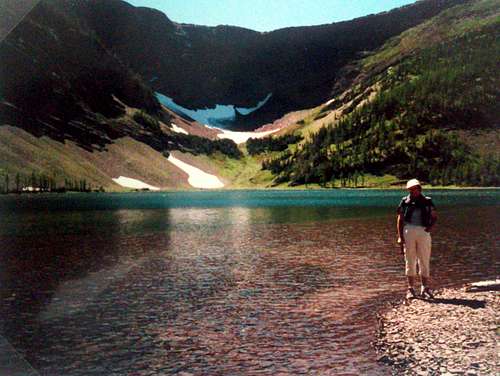
Mount Rowe is one of the twenty-five named peaks in Waterton Lakes National Park in Alberta Canada. At an elevation of 8100 ft (2469 m) above sea level it ranks very close to the average peak elevation for the area. Reaching its peak requires less than 3,000 ft (900 m) of vertical elevation gain, over approximately 5 miles (9 km). Its summit offers exceptional views of the surrounding peaks, lakes and forest.It is located just 5 km (3 miles) from the Canada/USA border, and a half kilometer from the Alberta/British Columbia border. The neighboring peaks include Festubert Mountain to the north west and Mount Lineham to the north, and Cameron lake lies to the south. The north side basin of the mountain is home to three lakes, known as the upper (two lakes) and lower Rowe lakes. The rocks around the lakes, and even up some of the gullies coming down from the ridge, are a very scenic red color and are a type of sedimentary rock known as argillite.
The peak is named after Frederick Valentine Rowe a lieutenant of the British Commission who surveyed the area in the late 1800s. North west of the named peak lies an unnamed peak which curiously stands taller than Mount Rowe.
  (Above image is displayed from Flickr and belongs to AlbertaScrambler) |
Mount Rowe sits to the left of center in Waterton Lakes National Park. Waterton was Canada's 4th national park, and is the smallest in the Canadian Rockies at a measly 505 sq km (195 sq. mi). To get an idea of just how small the park is, at its widest point it is about 30 km (less than 20 miles), and its largest length is around 23 km (14 miles). A 195 sq miles is a square approximately 14 miles long by 14 miles wide. Nonetheless for such a small area, Wateron is full of numerous mountains, lakes, streams and wildlife, and one could spend many years exploring it.
Getting There
As mentioned Mount Rowe is located in Waterton Lakes National Park in Alberta, Canada. This Park is situated 270 km (162 miles) south of Calgary, Alberta, 43 km (27 miles) west of Cardston, Alberta, and about 80 km (48 miles) from the St. Mary entrance to Glacier National Park, Montana. When driving to Waterton Lakes National Park it can only be accessed from its eastern side.From Calgary take Highway 2 south to Fort Macleod, then west on Highway 3 to Pincher Creek, then south again on Highway 6. The drive requires about three hours.
From Cardston take Highway 5 west, through the village of Mountain View. The drive is less than 40 minutes.
From Glacier National Park, Montana, take the Chief Mountain International Highway (closed in the winter). From the St. Mary entrance of GNP it is approximately a 1 hour drive. In the winter take Montana Highway 89 to Alberta Highway 2 to Cardston, then Highway 5 to Waterton.
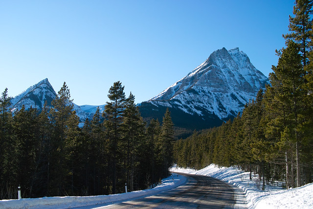
Once you arrive at the Park follow the entrance parkway (Highway 5) toward the town site, which is located 8 km (4.8 miles) down the road. En route, you will pass Mount Crandell, which is located directly across the highway from the famous Prince of Wales Hotel, about 1 km (0.6 miles) shy of the town. As you pass Mount Crandell, and start down the hill watch for the Akamina Parkway (aka Cameron Lake Road) on the right, as you will want to take that road. The Rowe Lakes trailhead, the typical starting point for climbing Mount Rowe, is located 10.2 km up this narrow winding road. Prior to the Rowe Lakes trailhead is the Lineham Falls trailhead at 8.8 km up the road. Just before the Lineham Falls trailhead at 7.7 km is the Discovery Well - a National Historical site commemorating the discovery in 1902 of the first producing oil well in Western Canada.
Click here for a map.
Camping
Camping is not allowed on Mount Rowe, however there are 9 wilderness campsites in Waterton. You should contact the park to make reservations for wilderness campsites.Additionally Parks Canada operates four campgrounds in Waterton Lakes National Park. Click here for details.
Routes
Route 1 - The Standard Route via Rowe LakesDrive up to the Rowe Lakes Trailhead as outlined in the getting there section. Follow the Tamarack Trail towards the Rowe Lakes for 5.2 km at which point you will come to a trail branching off to the left. The branching trail will take you to the Upper Rowe Lakes after 1.1 km. Proceed to the first Upper Lake and make your way around to its south side. From there look up and to the south and notice the North West Ridge above you, this is your destination. Pick whatever way up you like, as there is no designated or defined trail; it is a scramble to the peak.
Once you reach the ridge, the summit should be to your left and fairly obvious. From the top take in the views of the Rowe Lakes, Cameron Lake, Forum Lake and Wall Lake, as well as endless summits in Alberta, BC and Montana.
The advantage of the standard route (route 1) is that it follows a well maintained trail to this point - The Upper Lakes. From here it is a scramble to the peak.
At one time there were 3 cairns on this summit ridge which may or may not still be there. The first is a marker for the Alberta/BC border, the second the summit marker, and the third is further east along the summit ridge and is anyone’s guess as to what it is for – perhaps another marker for the Alberta/BC boundary.
Route 2 Southeast route.
Andrew Nugara in his book "More Scrambles in the Canadian Rockies: 2nd Edition" suggests as an alternative to the standard route mentioned above. The advantage of the standard route is that it follows a well maintained trail to the lakes at of base of the ridge. In comparison Nugaras southeast route is essentially a bushwhack approach followed by a scramble. Limited information about this alternate route can be found here.
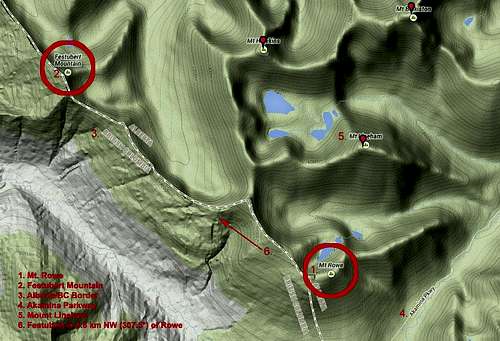
Map of Mt Rowe and Area
Weather
The summers in the Mount Rowe area are brief with some hot spells (high 35*C/94*F). Winters are long and relatively mild (high 10*C/50*F), with occasional warm spells caused by Chinook winds. This area is often one of Alberta's warmest places in the winter, despite ample snow and temperatures that can occasionally drop as low as -40*C/-40*F.Wind is a noticeable element of this area’s climate, and shouldn’t be ignored. Gusts of over 100 km/hr (60 mph) are common, but thankfully they occur mostly in the fall and winter rather than the summer. Note that gusts of over 150 km/hr (90 mph) have frequently been recorded in the area.
This area receives Alberta 's highest average annual precipitation of 1072 mm (42 inches) per year.
Red Tape
In the spring, summer, and fall, one must pay an entrance fee in order to get into Waterton Lakes Park, home of Mount Rowe. There is no fee in the winter. As of summer, 2011 the Canadian dollar daily rates were $7.80 per adult or $19.60 for a family/group. Click here for the most up to date rates.Also note the park has no gas or groceries available in winter.
When traveling to Waterton Lakes National Park from Glacier National Park in the US state of Montana one must be aware of the Canada Ports of Entry operating schedules. Chief Mountain port of entry is open seasonally (closed in Winter) from May through September and Carway/Peigan port of entry is open year round from 7:00 a.m. to 11:00 p.m.