
-
 3118 Hits
-
 82.48% Score
-
 15 Votes
|
|
Mountain/Rock |
|---|---|
|
|
46.74227°N / 11.40278°E |
|
|
Hiking, Skiing |
|
|
Summer, Fall, Winter |
|
|
7910 ft / 2411 m |
|
|
Overview
 The three summits of Gentersbergspitze / Monte dei Masi The three summits of Gentersbergspitze / Monte dei Masi |
Gentersbergspitze / Monte dei Masi is the central mountain of a ridge, which - at least in German - has been named after the mountain: Gentersbergkamm. It is by no means the most impressive or highest mountain of the ridge but its location made sure that it gets some of the attention. The ridge runs between two profound valleys in the middle of the Sarntal Alps, Penser Tal / Valle di Penes in the north-west and Durnholzer Tal / Valdurna in the south-east. Its central location ensures that it is wonderfully panoramic and indeed the traverse between Dürnholzer Jöchl and Astfeld / Campolasta is one of the most interesting routes in the range.
However, access is long. All trailheads are separated from the summits on the ridge by more than 1000m of elevation difference. Thus only few hikers attempt the traverse. Most either turn around at Durnholzer Jöchl or after reaching one of the endpoints of the ridge Karnspitz / Cima di Quaire in the north-east or Radelspitze / Cima Rodella in the south-west. The remainder (and main part) of the ridge remains solitary.
 |  |  |
Gentersbergspitze / Monte dei Masi itself barely stands out from the ridge. It is broad backed though at the northern and southern ends the broad back suddenly turns into steep slopes which drop down to two terraces on either side of the mountain. The mountain has several summits, all of which achieve very similar heights. Like the remainder of the ridge, the summits are maadde up from rotten schist-like rock and resemble dirt piles rather than mountain summits. Gentersbergspitze / Monte dei Masi is never climbed alone but rather as part of the Gentersbergkamm-Traverse.
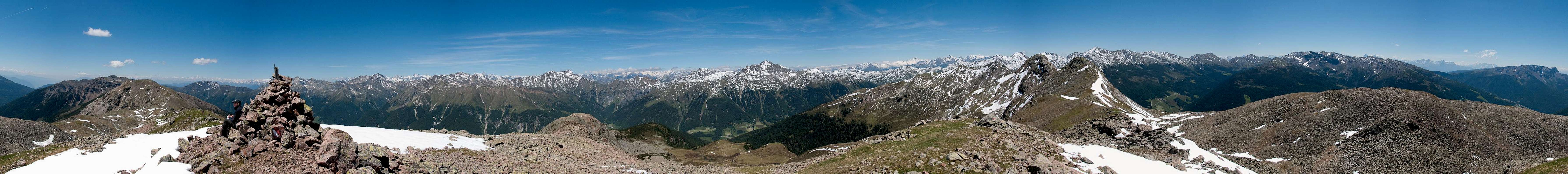
360° Summit Panorama
  |
Getting There
 The northern part of the Sarntal Alps as seen from Gentersbergspitze / Monte dei Masi
There are two reasonable trailheads for ^Gentersbergspitze / Monte dei Masi, one at Durnholz / Valdurna one in Pens / Penes, both in Sarntal / Val Sarentino
- Durnholz / Valdurna trailhead
- Take Brenner Motorway A22 to Bozen / Bolzano
- Drive through the city, following signs to Sarntal / Val Sarentino on SS508
- At Astfeld / Campolasta turn off onto SP137, direction Durnholz / Valdurna. You have to park outside the village and will be charged a fee of 3€.
- For Pens / Penes stay on SS508 until you reach the village. You can also reach the village from Sterzing / Vipiteno across Penser Joch / Passo di Penes (also SS508).
Red Tape
 The eastern part of the Sarntal Alps as seen from Gentersbergspitze / Monte dei Masi
There is no red tape in this area. Except for a few sheep and goats the area is not used for farming. In Durnholz / Valdurna you will have to pay a fee of 3€ for parking.
Accommodation
 Rosengarten and Latemar as seen from Gentersbergspitze / Monte dei Masi
Eisacktal / Valle Isarco
Bozen / Bolzano
Weather Conditions
Maps & Books
Maps
- Digital Maps
- Regular Maps
- Sarntal/Val Sarentino
Kompass Map WK 056
1:35.000
ISBN: 3-85491-340-0
- Brixen / Bressanone
Kompass Map WK 56
1:50.000
ISBN: 3-85491-063-0
- Bozen / Bolzano
Kompass Map WK 54
1:50.000
ISBN: 3-85491-061-4
- BOLZANO-RENON / BOZEN-RITTEN-TSCHÖGGLBERG
Tabacco Map 034
1:25.000
- MONTE SARENTINI / SARNTALER ALPEN
Tabacco Map 040
1:25.000
- Sarntal/Val Sarentino
Books
- Bozen-Salten-Schlern
Kompass Guidebook WF953
Kompass Verlag
ISBN: 3-85491-406-7
- Rund um Bozen
Helmut Dumler
Rother Verlag
ISBN: 3-7633-4267-2