
-
 4873 Hits
-
 79.04% Score
-
 10 Votes
|
|
Mountain/Rock |
|---|---|
|
|
46.71018°N / 11.47345°E |
|
|
Hiking |
|
|
Summer, Fall, Winter |
|
|
8494 ft / 2589 m |
|
|
Overview
 Getrumspitze / Cima Gethruna above Getrumsee / Lago Gethruna Getrumspitze / Cima Gethruna above Getrumsee / Lago Gethruna |
To the south the horseshoe shaped range of the Sarntal Alps / Monti Sarentini runs out in two branches, which more or less can be called high plateaus. The western branch, Tschögglberg barely surmounts 2000m while the eastern branch reaches almost 2300m in the panoramic and popular summit of Rittner Horn / Corno Renon. A huge mountain pasture, Villanderer Alm / Malga Villandro follows, north of which the high Sarntal Alps follow. One of the first of these higher mountains is Getrumspitze / Cima Gethruna.
Getrumspitze / Cima Gethruna forms an entity with its neighbour to the south, Blankenhorn / Corno Bianco, from which it is separated only by a small saddle and a distance of several hundred metres. In fact, the saddle, which separates the two summits of Getrumspitze itself is much more pronounced and certainly more impressive. Still, geologically, the distinction makes sense as both mountains are composed of different types of rock. On Getrumspitze you find a mixture of gneiss, porphyry and schist, while Blankenhorn glimmers with white limestone patches. Both mountains are very brittle which makes their ascent an easy, while somewhat disconcerting experience.
 |  |  |
Both mountains are located close to South Tirol's highest sanctuary, Lazfonser Kreuz / S. Croce di Lazfons, a pilgrimage chapel based at the base of neighbouring Kassianspitze / Cima San Cassiano. At the chapel you'll find a mountain hut (or rather inn), ehich ensures quite a lot of traffic on the neighbouring mountains. Most of this traffic is directed at Kassianspitze itself, but Getrumspitze also gets its share, though somewhat lesser.
There are three routes to the mountain, two of which start at the sanctuary:
- Blankenhorn / Corno Bianco east ridge From Lazfonser Kreuz hike through the Lückl Saddle to Getrumsee / / Lago Gethruna. From here a steep but easy couloir takes you to the broad, plateau-like east ridge of Blankenhorn, from where several hundred of easy metres lead you to the main summit of Getrumspitze / Cima Gethruna
- Getrumspitze / Cima Gethruna east ridge From Kassianspitze / Cima San Cassiano a ridge traverse leads to the Getrumspitze / Cima Gethruna east summit. Descend the north-west ridge of Kassianspitze, then ascend the long east ridge of Getrumspitze. To reach the main summit you will have to descend into a saddle precariously. From there a similarly horrible path leads to the main summit.
- Blankenhorn / Corno Bianco west ridge The shortest, easiest and most popular route makes use of the cable-car which runs from the village of Reinswald / San Martino to Pichlberg. From there a ridge traverse takes you across Jochplatte and Blankenhorn to the Getrumspitze main summit.
 |  |  |
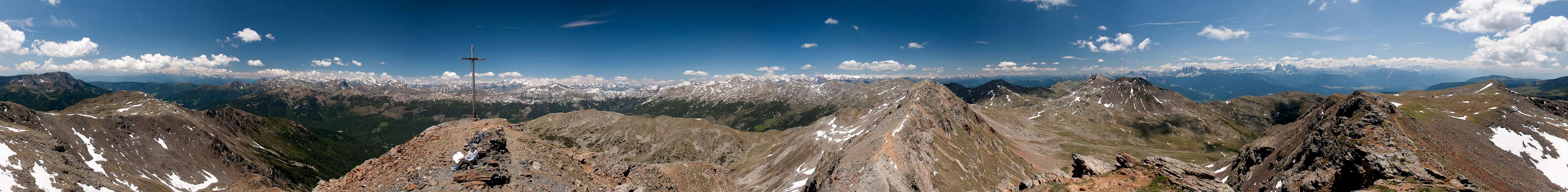
Like all the mountains on the western branch of the Sarntal Alps / Monti Sarentini horseshoe, Getrumspitze is one wonderful lookout peak. If you have the luck of standing there in perfect weather - and I had this luck - you will be stunned by the sheer number of mountains all around. Dolomites, Zillertal Alps, Stubai Alps, Ötztal Alps, the Ortler Group and the Brenta Group can be seen and the following panorama gives an indication of what such a day might look like.
360° Summit Panorama
  |
Getting There
 Getrumspitze / Cima Gethruna seen from Durnholzer Joch
There are two reasonable trailheads for Getrumspitze / Cima Gethruna, one at Reinswald / San Martino in Sarntal / Val Sarentino (or rather Durnholztal / Valdurna) and Lazfons in Eisacktal / Valle Isarco. Both trailheads are connected by the pilgrimage trail to the sanctuary at Lazfonser Kreuz / S. Croce di Lazfons
- Reinswald / San Martino trailhead
- Take Brenner Motorway A22 to Bozen / Bolzano
- Drive through the city, following signs to Sarntal / Val Sarentino on SS508
- At Astfeld / Campolasta turn off onto SP137, direction Durnholz / Valdurna
- At Unterreinswald / San Martino Bassa turn onto SP138 to Reinswald / San Martino. Park at the cable-car station.
- Lazfons trailhead
- Take Brenner motorway A22 to the exit Klausen / Chiusa.
- Take SP74 to Feldthurns / Velturno
- Turn left onto SP142 to Lazfons
Red Tape
 Blankenhorn / Corno Bianco and Getrumspitze / Cima Gethruna
There's no red tape. You might have to cross pasture gates which you are requested to shut behind you.
Accommodation
[img::aligncenter:medium:Getrumspitze / Cima Gethruna west ridge in front of the Stubai Alps]Eisacktal / Valle Isarco
Bozen / Bolzano
Weather Conditions
Maps & Books
Maps
- Digital Maps
- Regular Maps
- Sarntal/Val Sarentino
Kompass Map WK 056
1:35.000
ISBN: 3-85491-340-0
- Brixen / Bressanone
Kompass Map WK 56
1:50.000
ISBN: 3-85491-063-0
- Bozen / Bolzano
Kompass Map WK 54
1:50.000
ISBN: 3-85491-061-4
- BOLZANO-RENON / BOZEN-RITTEN-TSCHÖGGLBERG
Tabacco Map 034
1:25.000
- MONTE SARENTINI / SARNTALER ALPEN
Tabacco Map 040
1:25.000
- Sarntal/Val Sarentino
Books
- Bozen-Salten-Schlern
Kompass Guidebook WF953
Kompass Verlag
ISBN: 3-85491-406-7
- Rund um Bozen
Helmut Dumler
Rother Verlag
ISBN: 3-7633-4267-2