Overview
![Kassianspitze and Samspitze]() Kassianspitze and Samspitze from Blankenhorn Kassianspitze and Samspitze from Blankenhorn |
Together with
Getrummspitze / Cima Getruna, which is 8m higher,
Kassianspitze / Cima San Cassiano is the highest mountain of its subgroup among the
Sarntal Alps. Among this horseshoe-shaped mountain range it takes one of the southernmost positions before the giant pasture of
Villanderer Alm out of which only occasional flat-topped mountains rise. And thanks to its location close to one of Südtirol's oldest pilgrimage chapels, it is also one of the most important and most visited mountains of the area.
In ancient times, when neither the
Eisacktal Valley / Valle d'Isarco nor the
Sarntal Valley / Val Sarentino could be traveled due to the wild and narrow gorges at their southern ends the high plateaus and pastures high above were of huge importance. Many traffic routes led across them remainders of which can be found until today. The northern end of these high roads was near
Latzfons and
Feldthurns, were an easy slope facilitates ascent and descent into Eisacktal (east). In addition a similarly easy route leads through
Getrumtal / Val Getruna into
Sarntal / Val Sarentino in the west. All these routes and trails culminate in the
Lückl Saddle (2370m), in the close proximity of which a pilgrimage chapel was erected:
Heiligenkreuz / San Croce di Lazfons. Today it is best known by the German name of the inn / hut which accompanies it: Latzfonser Kreuz.
Inn and chapel are located at the mouth of the cirque of three mountains:
Samspitze (2552m) in the west,
Kassianspitze / Cima San Cassiano (2581m) in the centre (north) and
Ritzllarspitze (2474m) to the east. The highest one of them,
Kassianspitze / Cima San Cassiano, can be reached by several hiking trails, the most popular of which is the scramble to
Kassiansee / Lago San Cassiano in the centre of the cirque, from where a roundaboutish trail leads across the west ridge of the mountain. More interesting are the ridge traverses across either of the other summits which can be combined in a "tour de cirque". Distances are small and such a tour will take little more than two hours when started at
Latzfonser Kreuz. However, all three mountains are composed of horrid rock and the exposed traverse across Samspitze can be considered quite gangerous.
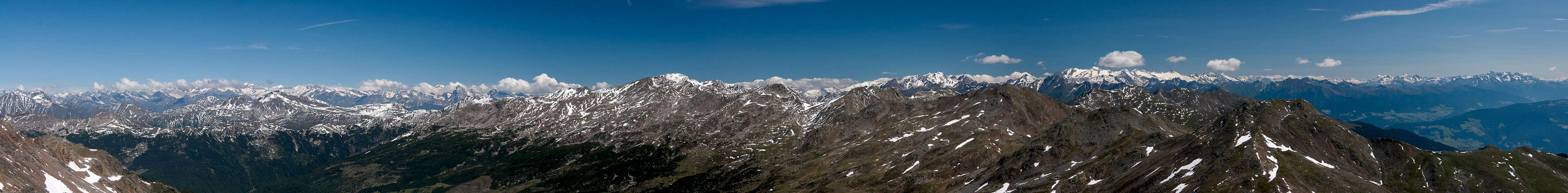
Kassianspitze / Cima San Cassiano is a wonderful lookout summit thanks to its rather solitary location close to the eastern end of the
Sarntal Alps. However, the summit is very small and with the number of daily visitors it can become quite crowded. Moreover, a 360° photographic panorama has been installed on top, indicating the important summits all around. There is a bench and a summit cross, all competing for the little space there is.
Summit Panorama
Ötztal-, Stubai- and Zillertal Alps from Kassianspitze |
![Zillertal Alps Main Ridge]() Zillertal Alps Zillertal Alps |
![Tribulaun Group]() Tribulaun Group Tribulaun Group | ![Hasenöhrl and Königspitze]() Hasenöhrl and Königspitze Hasenöhrl and Königspitze | ![Hochwilde]() Hochwilde Hochwilde |
![Hohe Weiße and Similaun]() Hohe Weiße and Similaun Hohe Weiße and Similaun | ![Hinterer Seelenkogel]() Hinterer Seelenkogel Hinterer Seelenkogel | ![Hochfirst]() Hochfirst Hochfirst |
Getting There
![Villanderer Alm]() Villanderer Alm with Getrumspitze and Kassianspitze
Villanderer Alm with Getrumspitze and Kassianspitze
There are two reasonable trailheads for
Kassianspitze, one at
Reinswald / San Martino in
Sarntal / Val Sarentino (or rather
Durnholztal / Valdurna) and
Lazfons in
Eisacktal / Valle Isarco. Both trailheads are connected by the pilgrimage trail to the sanctuary at
Lazfonser Kreuz / S. Croce di Lazfons.
- Reinswald / San Martino trailhead
- Take Brenner Motorway A22 to Bozen / Bolzano
- Drive through the city, following signs to Sarntal / Val Sarentino on SS508
- At Astfeld / Campolasta turn off onto SP137, direction Durnholz / Valdurna
- At Unterreinswald / San Martino Bassa turn onto SP138 to Reinswald / San Martino. Park at the cable-car station.
- Lazfons trailhead
- Take Brenner motorway A22 to the exit Klausen / Chiusa.
- Take SP74 to Feldthurns / Velturno
- Turn left onto SP142 to Lazfons
Red Tape
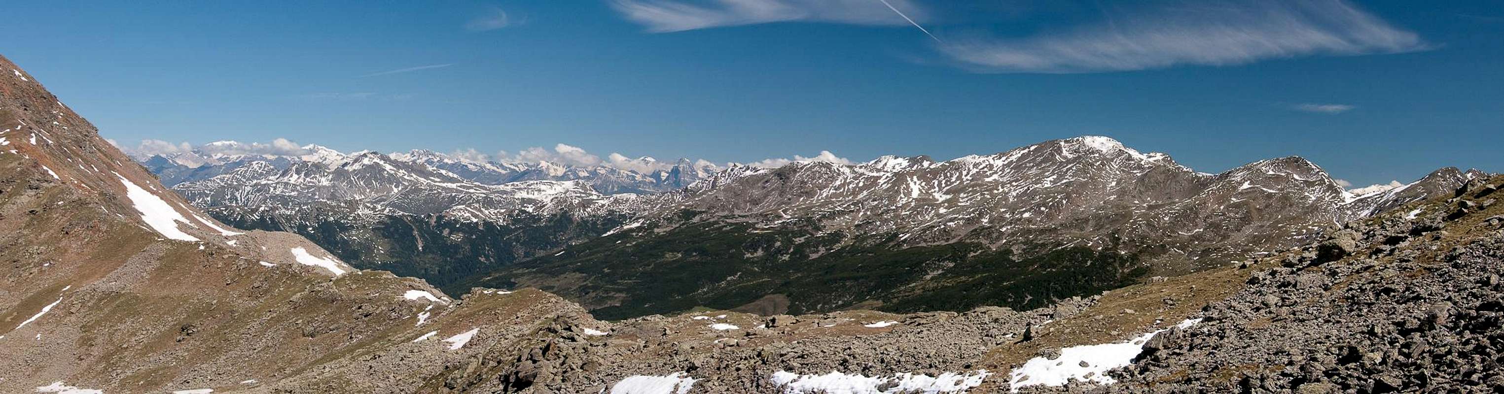
Sarntal Alps seen from the saddle separating Kassianspitze from Getrumspitze |
There's no red tape. You might have to cross pasture gates which you are requested to shut behind you.
Accommodation
Eisacktal / Valle Isarco
Bozen / Bolzano
Weather Conditions
Maps & Books
Maps
- Digital Maps
- Regular Maps
- Sarntal/Val Sarentino
Kompass Map WK 056
1:35.000
ISBN: 3-85491-340-0
- Brixen / Bressanone
Kompass Map WK 56
1:50.000
ISBN: 3-85491-063-0
- Bozen / Bolzano
Kompass Map WK 54
1:50.000
ISBN: 3-85491-061-4
- BOLZANO-RENON / BOZEN-RITTEN-TSCHÖGGLBERG
Tabacco Map 034
1:25.000
- MONTE SARENTINI / SARNTALER ALPEN
Tabacco Map 040
1:25.000
Books
- Bozen-Salten-Schlern
Kompass Guidebook WF953
Kompass Verlag
ISBN: 3-85491-406-7
- Rund um Bozen
Helmut Dumler
Rother Verlag
ISBN: 3-7633-4267-2

 5414 Hits
 83.1% Score
 16 Votes
 Kassianspitze and Samspitze from Blankenhorn


 Zillertal Alps
 Tribulaun Group
 Hasenöhrl and Königspitze
 Hochwilde
 Hohe Weiße and Similaun
 Hinterer Seelenkogel
 Hochfirst
 Villanderer Alm with Getrumspitze and Kassianspitze