
-
 22377 Hits
-
 79.78% Score
-
 11 Votes
|
|
Route |
|---|---|
|
|
54.45543°N / 3.19996°W |
|
|
Scrambling |
|
|
Summer |
|
|
A long day |
|
|
Class 4 |
|
|
UK Grade 3 scramble |
|
|
II |
|
|
OVERVIEW
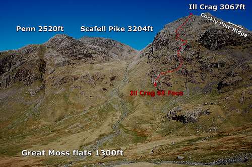
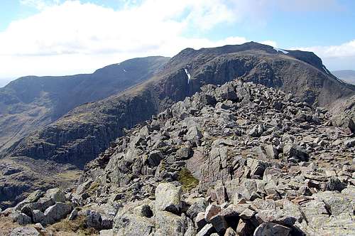
Ill Crags South East Face and Scafell Pikes
Ill Crags SE face is one of the finest ‘hard’ scrambles in the Lake District. With a vertical height of 1300ft/400m it is also one of the longest. It finishes right at the very top of Ill Crag, at 3067ft/935m – which is one of the subsidiary tops of Scafell Pike, highest summit in England at 3204ft/978m.
The route rises up out of Great Moss, a remote sanctuary at the northern extremity of Upper Eskdale. Access routes are long from either the North (Borrowdale) or South (Eskdale). Indeed, by English standards this route is about as remote as it gets; a true mountaineering expedition.
The SE Face of Ill Crag constitutes a rough triangle, whose base is about 600m across and with apex topped by twin summits about 75m apart. The right/northern edge of the triangle is formed by Cockly Pike Ridge, a Grade 1** scramble terminating at the northern and lower of the two summits. Our route follows a less defined path weaving in and out of slabs and buttresses along the left or southern edge of the face – and terminates at the higher of the two summits.
From the top of Ill Crags it is an easy matter to reach the highest point in England – by joining the main tourist path 200m to the north, heading west over another subsidiary summit Broad Crag and thence up to the summit of Scafell Pike. This extension adds another mile in distance and a total of another 500ft/150m ascent – about 45 minutes.
Seriousness: This is a remote and little frequented mountaineering route. Indeed, this is one of its attractions. However this means route finding poses additional challenges – with next to nothing by way of a trail to mark the way, nor the ‘polish’ which tends to mark the rocks on more accessible climbs. There are some signs to show the way, but they are very subtle and testing of route finding skills. This is not a route to be attempted in poor visibility.
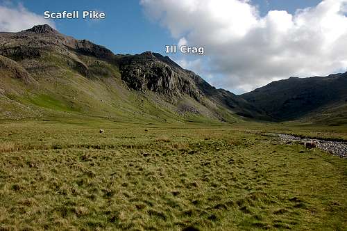
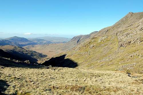
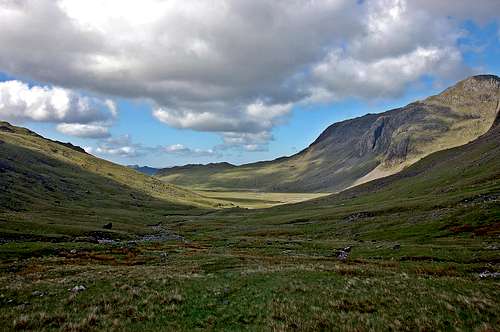
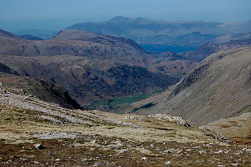
The valley of Great Moss, with Scafell Pikes above and Ill Crags in far distance
Because the route is complex, it is helpful to break up description into 4 distinct sections:
- The Lower Slabs.
- Central Slabs.
- Upper Buttress.
- Final Rib.
Grade: The route falls into the category of ‘hard scramble’ or ‘easy rock climb’. With an international readership in mind, using the 5 most used classification systems, the following grades will be about right:
- UK scramble Grade 3*** (*system denotes quality)
- UK climbing adjectival grade ‘Moderate’
- French adjectival grade ‘Peu Difficile’
- UIAA Grade II
- USA Class 4
Exposure: South-East – so catches the morning sun, in shade late afternoon.
GETTING THERE
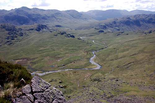
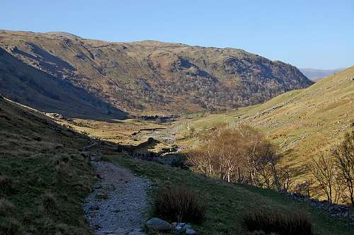
Looking south over Great Moss and River Esk disappearing into gorge
From the South:
Parking is available at Brotherilkeld (54°24’24.76’’N, 3°13’15.33’’W) OS GR 211 011 – about 3.5km to the east of Eskdale (which has road and rail links). From here approach follows course of the River Esk for 3km, to where river joined by the Lincove Beck, which must be crossed via a little bridge, before continuing to follow River Esk into a gorge. At this point there is the option to follow a straight forward path high above, or in dry weather and more adventurous: to follow a Grade 2 scramble up waterfalls in the bottom of the gorge. Even in dry conditions a certain amount of paddling may be needed for the latter variation – which may also add an extra hour to the day. Following normal approach distance from Brotherilkeld to Upper Eskdale is about 5 miles with 1000ft ascent = 2-3 hours.
It is also possible to reach Upper Eskdale from Cockley Beck and Moasdale, also to the south.
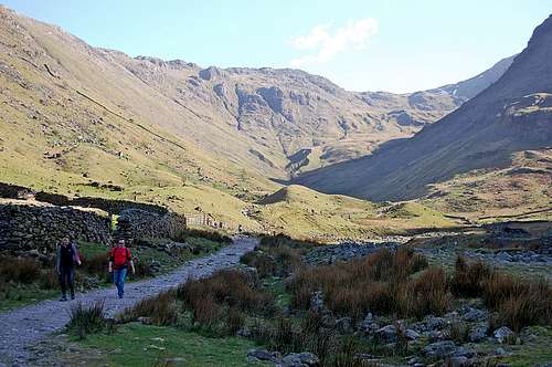
Looking up towards Great End early part of northern approach to Ill Crags
First sight of Ill Crags and below, Great Moss - from Esk Hause
From the North:
Parking is available at Seathwaite (54°29’59.62’’N, 3°10’45.54’’W) OS GR 236 123, at southern end of Borrowdale. From here follow path south alongside Grains Gill Beck for 2km before rising steadily up to the base of the spectacular precipices of Great End. At this point there is a T junction. Follow route to left (south east) and gently rising to reach the flat area known as Esk Hause at 759m, 2300ft (OS GR 233 082). Descend 1000ft from Esk Hause following narrow valley to the south south west towards Great Moss. Follow banks of a little stream which will eventually become the River Esk.
At OS GR 227 066 and at start of Great Moss Flats, the stream is joined by another smaller stream descending the narrow side valley of Little Narrowcove to the northwest.
Final approach:
Both the northern and southern approaches converge at the confluence of streams at the entrance to Little Narrowcove. The start of the climb is at OS GR 226 069, about 300m distance away and 100m above the confluence, up grassy slopes to the northwest.
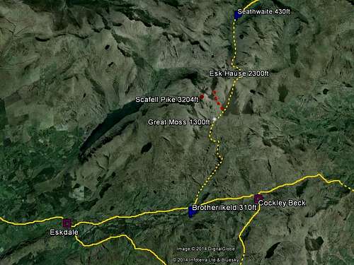
Google Earth view showing approaches to Great Moss and Ill Crags
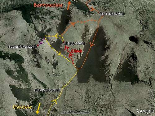
Google Earth view of closer approaches to Great Moss & Ill Crags
ACCOMODATION
YHA
Bed & Breakfast
There are at least 2 B&B options within 3 miles of Borrowdale to the north, but not so easy to find options for Eskdale side. See link:
Camping
In addition Great Moss flats offer near perfect camping out in the wilds at the foot of the climb.
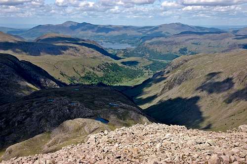
The Valley of Borrowdale and distant Keswick as seen from top of Great End
Plenty of excellent camping options at Great Moss
THE ROUTE 1: INTRODUCTION
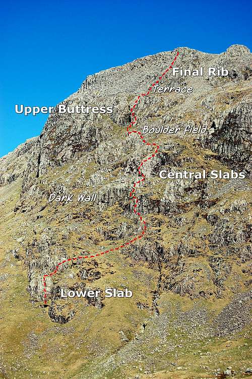
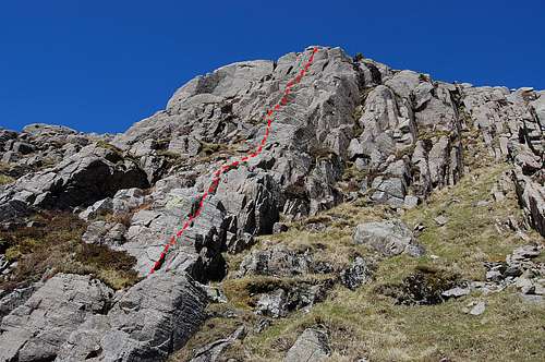
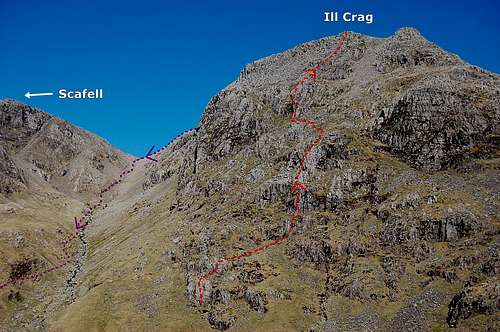
Ill Crags SE Face - topo of route from slopes of opposite side of valley
Note: in description all references to Left and Right will be as if standing and facing uphill in the direction of ascent.
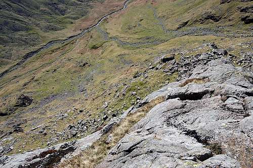
As described in the overview above, the climb is complex and a challenge in terms of route-finding skills. Viewed from the depths of Great Moss flats the south east flank of Ill Crags is incredibly foreshortened and large sections are difficult if not impossible to see. If unfamiliar with the route; I would recommend crossing the river Esk and climbing the slopes to the east (leading up towards Esk Pike) to get a better view, before starting the climb. An ascent of about 300ft/100m is adequate – and well worth the effort. The photo to the left is what I saw when I did just that just before making the climb on 18th April 2014.
It can be seen that the route is divided into 4 sections by natural barriers of slabs/buttresses – which have to be surmounted. The ‘line’ is far from straight and weaves about to find the most straight forward breeches in the ramparts. Roughly speaking these breeches seem to be highlighted by a slight paleness, which suggested less moss adherent to the rock at these places. I found little else to give sign of the route. There were no ‘trails’ to see. Perhaps the only sign of the passing of the few who climb this route is this stripping away of some of the mossy coating to the rocks.
It should be said that the quality of the (presumably igneous) rock is astonishingly excellent. For the majority of the route it is clean and incredibly rough in texture, to the point that it probably provides good purchase even when wet. In this respect it is similar to the rough ‘Gabbro’ of which the Cuillin Hills of the Island of Skye are composed – but somewhat paler in colour.
Ill Crags SE Face - foreshortened view from close up - hard to pick out upper parts
THE ROUTE 2: LOWER SLABS
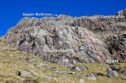
Close up of Ill Crags Lower Slab
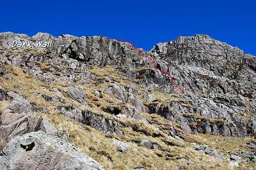
Above Lower Slabs looking at next section - note 'dark wall'.
It is easy to identify the start at an otherwise clean sweep of slab broken by a ledge and to the left of a mossy side wall – at OS GR 226 069. Climb the easy angled lower section followed by the steeper section above the ledge.
Above this initial slab broken ground stretches off to right (north) and a prominent dark wall is in view. The next easy slabs start below and to the right of this wall. The route can be identified by the relative pallor of the rock as well as a less steep angle. It is just a matter of picking a way across grassy slope broken by boulders and little bluffs to reach the bottom of this next obstacle. At some point move left and then access a narrow grey rib which terminates at a grassy area distinguished by the presence of a large block. Another short rocky scramble leads to a grassy terrace below the somewhat intimidating looking fortification of the Central Slabs.
Climbing the slabs alongside the dark wall
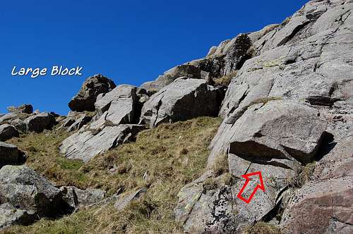
Above the dark wall - the striking 'large block' is visible
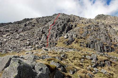
THE ROUTE 3: CENTRAL SLABS
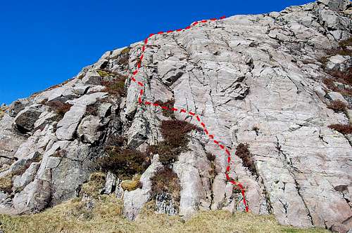
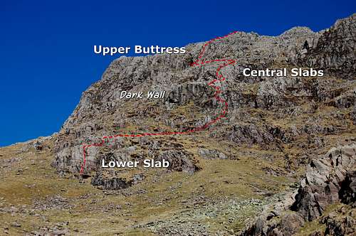
Ill Crags - topo of route on the Central Slabs
Looking down from top of the Central Slabs
At first sighting the Central Slabs appear as a formidable if not impregnable wall. In R.B. Evans guidebook the height is given as being 160 feet – ‘it requires a long run-out of rope’... I didn’t think it was quite as much as that – and after the steepness of the initial 50 feet or so, the angle does fall back somewhat. For those who prefer to climb the pitch roped there are a few potential sling placements to act as runners.
Whilst I don’t agree with the given length of the pitch, I do agree with R.B. Evans assertion that the climbing is easier than it looks.
Facing the slabs there is obvious broken heathery groove at the left hand edge of the otherwise clean sweep of pale rock – with its characteristic horizontal stratification banding. Starting 20ft or so to the right of this groove there is straight forward climbing on excellent holds, which naturally angles up and leftwards, above a heathery ledge and thence to the edge of the groove. This edge is then ascended directly for a little way – and thence via right-wards moves onto a prominent rib, where the angle leans back slightly.
At the top of the rib I expected (from the guidebook description) to immediately see the (even more) formidable looking Upper Buttress, beyond a scree-field. However, it is necessary to climb a little higher over some broken ground – and thence to more of a boulder field than scree. Now the Buttress comes into view – up and across to the left. It does indeed look even more formidable than the one below!
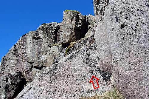
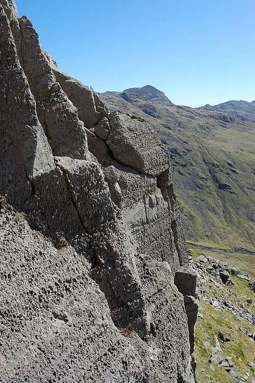
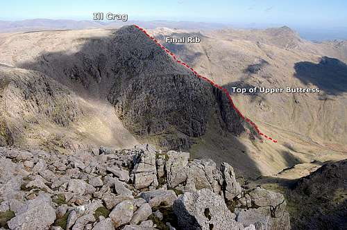
THE ROUTE 4: UPPER BUTTRESS
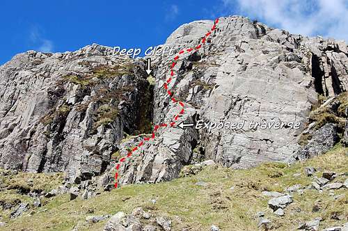
Ill Crags SE Face - Upper Buttress
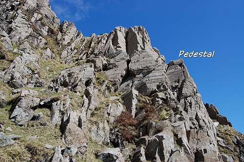
Starting Upper Buttress - Pedestal before exposed traverse in view
After a careful scramble over large rocks another grassy terrace is reached just below this last serious obstacle. It can be seen that the buttress is breeched by a very deep dark mossy groove – almost cave-like. This intersects with a scree-shoot descending across lower border of the crag from the left – making a V whose right fork is vertical.
Inside the bottom of the deep groove and to the left is a prominent ‘nose’. This should be approached until an easy rib comes in to view up to the right - which may be ascended by those of timid disposition, not wishing to take the more challenging route on the exposed precipices even further to the right of the easy rib.
Looking across the exposed traverse
A little way up the easy rib and to the right there is a rocky pedestal, quite high up. This little platform needs to be accessed in order to reach the next and most exposed part of the entire climb. Standing on the top further excursion to the right looks to be the last place you’d want to go (especially if climbing un-roped!). However, this is indeed where the route goes – and it is a delight to climb on small but secure holds on the astonishingly rough textured rock. After the short exposed traverse the route heads straight upwards following best line of holds, which are again small, but abundant. Again, for those using a rope, there are plentiful potential sling placements for runners.
A small wall gives way to another rocky rib – and thence with a gradual easing of angle, to the top of the buttress.
On top of the buttress is yet another terrace – nicely exposed to the view and the sun. The serious parts of the climb are over now – and it is an opportunity to relax, enjoy the view and take a few photos of magnificent vista expanding below. If you are an aged person like me, it is a great place for an afternoon nap!
Top and easier part of the Upper Buttress
THE ROUTE 5: FINAL RIB
Looking down from sunny terrace at top of the Upper Buttress
Looking at the Final Rib to the top of Ill Crags
Looking upwards from the sunny terrace the very upper part of Ill Crag is in view. Straight ahead is the higher and left-most of the two rocky tops. The route takes the obvious rocky rib heading straight for this top, with scree on either side. R.B. Evans describes this section as a ‘delightful staircase’ – and I have to say, I completely agree. The horizontally stratified lower slabs have given way to a remarkable blocky upper section composed of no less clean and rough textured rock – and it is indeed just like some kind of giant staircase heading up into the sky.
ILL CRAGS SUMMIT
View south east from top of Ill Crags - over Great Moss, Penn in middle distance
View from top of Ill Crags towards summit of Scafell Pike
The summit is reached abruptly. It is a small horizontal boulder field which turns out to have three slight prominences (as opposed to the two which can be seen from below). There are superb views to be had looking down the way of ascent into Great Moss far below. Turning to the southwest there is the boulder mound of Broad Crag a few hundred yards away. A little higher and about a mile away; the summit of Scafell Pike is visible – distinguishable by massive flat topped cairn – which on a good day will be swarming with hoards of ant-like people, most of whom will have ascended via the much easier ‘tourist path’ routes.
SCAFELL PIKES SUMMIT
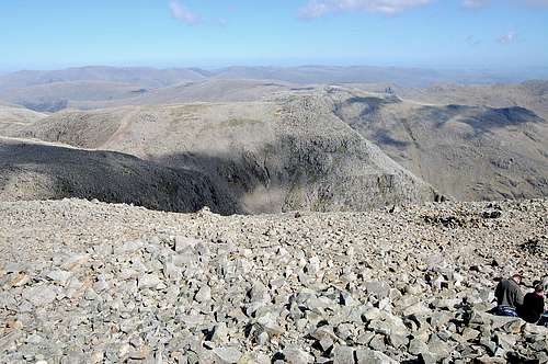
View from summit of Scafell Pikes of the top of Ill Crags
Better view of Ill Crags from just below top of Scafell Pike - SE face in profile
It would seem a shame to climb all the way to the top of Ill Crag and not find 45 minutes to visit the top of the highest point in England. After the solitude of the precipices of Ill Crag, it may come as a shock to be back amongst the hoards... but the view from the slightly higher vantage point is worth the effort – especially looking back at the climb just completed. The best view of Ill Crags is obtained by dropping a few metres below the summit towards the east – and then from the vantage point of a boulder terrace most of the route of the Ill Crags SE Face can be seen in profile. With the two little rises over Broad Crag and back up to Ill Crags it will take about half an hour to make the return trip – for those returning to Borrowdale. For those returning to Eskdale; this return is cut short before the riser to Broad Crag, in order to turn right at the col – and make the steep descent down to Great Moss.
DESCENT
View of SE Face: possibilities for escape routes to R + descent route to Eskdale
Escape Routes
To add to the note on ‘seriousness’ above: it is worth pointing out that, especially the middle two sections, would be extremely difficult to reverse in event of a deterioration in conditions (or a major route finding error). In this event I would recommend breaking out to the right as facing upwards*, towards the easier terrain of Cockly Pike Ridge. In the middle of the climb progress will be blocked by presence of a big dark buttress (which the ridge goes over top of) – and from there it ought to be possible to pick a careful way down, down scree shoots and boulder fields. Above the big buttress probably the best option is to keep going all the way to the ridge and then climb on straight forward terrain to the lower top of Ill Crag – and then on to the relative safety of the main tourist path between Scafell Pike and Borrowdale.
*Trying to break out to the left as facing upwards would be an extremely bad idea since all the steepest parts of the various buttresses lie that way!
Return to Borrowdale
It is a simple matter of following the main tourist path, past Great End and back to Esk Hause – and thence back to Seathwaite.
Return to Eskdale
At the col between Broad Crag and Scafell Pike a rough path descends steeply to the southeast – and after loss of 1520ft/465m height the flats of Great Moss are reached – and thence a return following the River Esk all the way back down to Brotherilkeld.
Descent to the north - Borrowdale in view
Back into Borrowdale after a long day - slopes to Esk Hause & Great End behind
TIMINGS
The climb: 1300ft/400m ascent = 1 ½ hours un-roped – up to double that climbing the harder sections in roped pitches. A compromise may be for a pair to tackle the route alpine style, moving together roped up, with leader placing slings and second removing while moving simultaneously. A competent and practised pair could probably climb the route in under two hours
in this way.
Northern (Borrowdale) approach: 2-3 hours from Seathwaite to the climb via Esk Hause; 2 hours for descent from top of Ill Crag – adding in another 1 ¼ hours if the detour to the top of Scafell is taken. Grand total all included = 7-10 hours - OR 5-8 hours without including Scafell summit.
Southern (Eskdale) approach: 3 hours from Brotherilkeld to the climb via Esk Gorge; 3 hours for descent via Broad Crag – adding in an extra ¾ hour if summit of Scafell taken in. Grand total 6-7 hours all included - OR 6 hours without including Scafell summit.
From either direction the Ill Crags South-East Face expedition is a long day by English standards.
Entering Borrowdale early evening after a long day
EQUIPMENT
Usual hill attire and wet weather gear. Compass/whistle/torch. First Aid Kit.
Helmet.
Rope, harness and small selection of slings – even if to be climbed ‘solo’ (to protect an unscheduled descent).
On the glorious day I had on 14th April 2014: sunblock and sunglasses!
Map: OS Explorer Map, sheet OL6, “The English Lakes, South-western area – Coniston, Ulverston & Barrow-in-Furness”
REDTAPE
None in particular – beyond usual following of the country code and care round any live-stock especially in Lambing season April/May time.
It is advisable to let someone know where you are going, especially if solo climbing – and especially since the route is remote and infrequently visited. (On a perfect day on 18th April 2014 I didn’t see a soul the entire time on the climb – and then not until I reached the summit and joined the main tourist routes).
LINKS/GUIDES
Guide Books
“Scrambles in the Lake District” volume 1, South Lakes by R.B. Evans – 1st published 1982, revised 2005 – Cicerone Press
“Scrambles & Easy Climbs in the Lake District” by Jon Sparks & Judith Brown – 1st published 2003 by Grey Stone
Books.
Useful Links
Mountain Weather Information Service - Lake District page
I hope you have as much fun on this climb as I did!