
|
|
Mountain/Rock |
|---|---|
|
|
45.95485°N / 10.87058°E |
|
|
Trentino |
|
|
Hiking, Mountaineering, Trad Climbing |
|
|
Spring, Summer, Fall, Winter |
|
|
4636 ft / 1413 m |
|
|
Overview
Monte Biaina 1413 m
Monte Biaina 1413 m is an interesting elevation located to the South and above the villages of San Giovanni al Monte and Marcarie. It is a mountain made up of a long wooded ridge supported by high and steep rocky walls facing East that overhelm the road joining the town of Arco to San Giovanni al Monte, while the wooded West face overlooks the Val Lomasone.
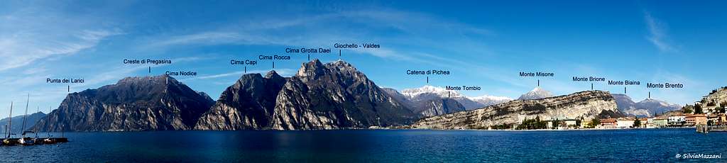

This ridge is oriented in a North-South direction and is the continuation towards the South of the Monte Brento summit ridge. Covered by a dense forest, at first of lush beech trees and then of firs, it's crossed by the Normal route of ascent to the summit. On the described rock walls facing East there are some difficult climbing routes.
Getting There
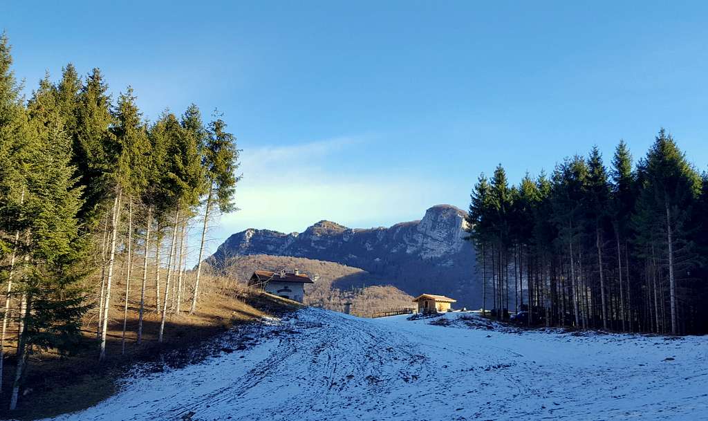
The starting point of the Normal route is the nice village of Marcarie 1104 m
Road to San Giovanni al Monte
From Varignano, a hamlet of Arco, take the road to San Giovanni al Monte. Pass the hamlet of Padaro and follow the road until you reach the small parking lot just before the Refuge San Giovanni and the church. Continuing on the road you arrive in Marcarie.


Route from S. Giovanni al Monte
Monte Biaina from San Giovanni al Monte
Difficulty: EE, F+ in wintertime in presence of snow
Difference in level: 300 m.
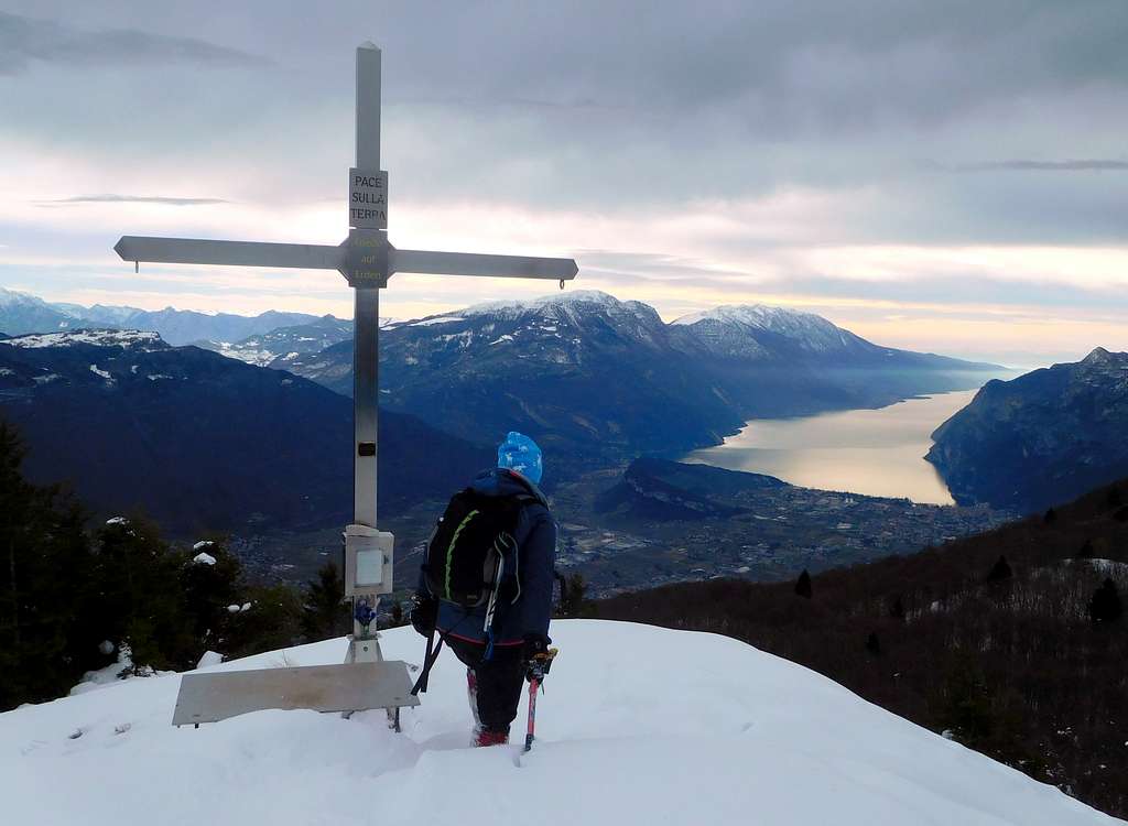
Monte Biaina is a fine destination to be climbed along an easy and pleasant itinerary, developing partly on a forest road surrounded by a beautiful beech forest and partly on a path that continuing in the upper fir forest leads to the summit of M. Biaina. From here you can enjoy a superb view of the Garda Lake and the surrounding mountains Recommended and easy to climb even in half a day.


Route description
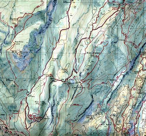
The starting point is the Rifugio Malga San Giovanni. Alternatively it's possible to start the climb further on in Marcarie, but here it is more difficult to park the car. In Marcarie ignore the road to the right to the Rifugio Calino and, along the dirt road on the left, go on the side of Val Lomasone reaching the fine and broad grassy clearing named Prai da Gom m. 1135.


Leave the road and take a large forest trail to the left (signposts "Monte Biaina", path n. 407), which leads into the lush beech woods. The path climbs with a series of hairpins, passes on the Eastern side (towards Arco), continues roughly on the ridge, alternately on the East and West side, getting a wooded saddle where the trail becomes narrow. Where the forest is clear, the view of the Sarca Valley to the East is dominated by Monte Stivo.

The trail now crosses the steep West side of the mountain, gets to the base of a rocky wall, continues traversing in the woods and, after some rocky outcrops, reachs another broad saddle. A gentle lawn where you notice a wooden observatory descends to the left.


Once you reach the SW part of the saddle, take up the ridge offering several beautiful views of Monte Misone and the deep ravine of Valle del Tovo. You overcome a series of humps and climb with a last effort to the summit of Mount Biaina to enjoy the view.
Descent: reversing the same itinerary
Route from Mandrea
Monte Biaina from Mandrea
Difficulty: EE
Difference in level: 800 m.
The itinerary starts from Mandrea 620 m, a locality in the municipality of Arco that can be reached from Varignano, a hamlet of Arco, in about 15 minutes by car on the Varignano - Padaro - San Giovanni road which goes up to S. Giovanni al Monte. On in the tiny locality of Mandrea, take the path 407 starting on the left hand of the road just in front of the first house on the right, enters the woods and moderately but constantly climbs uphill until it crosses the forest road coming from Clef.
Keep going up following briefly the road and after about 30 m. the path turns right into the woods. The path climbs constantly crossing the forest road a few times and arrives after a steep brief stretch at a new intersection with the forest road where there is a signpost with different directions. Take the indication "Monte Biaina" 407a to the left, following the forest road for about 500 meters until you reach a meadow widening on the right, in front of which you leave the forest road to take a narrow path on the left (signpost). The path climbs very steeply through the woods until it reaches the wooded summit ridge, which is followed by several ups and downs until it reaches the summit.
Red Tape
No fees, no permits required
When to Climb
All year round. Winter ascents of Monte Biaina - in presence of snow - may be a bit challenging and are advisable only with well settled snow.

Where to stay
In the vicinity there is the Rifugio Malga San Giovanni. Otherwise Arco and the close Valle del Sarca offer different kinds of accomodation.
Hiking grades of difficulty
T - Turistico (Tourist): Itineraries on wide, clear and well worn paths, sometimes on mule tracks or gravel roads. The routes are never exposed, don't give any orientation problems and don't exceed 2500 meters of altitude. Suitable also for children
E - Escursionisti (Hikers): Itineraries on marked trails, even narrow and with possible steep and impervious sections. They are never exposed and don't give any orientation problems. They can tread different kinds of ground, such as forests, gravel, meadows, pastures, easy rocks, etc.). They form the majority of the trails that wind up in the mountains and require a certain habit to walk; you need equipment suitable for the altitude and resistant footwear with soles suitable for rough terrain
EE - Escursionisti Esperti (Experienced Hikers): Itineraries for hikers with experience and good knowledge of the mountain. Some of these paths may have exposed sections, however brief, which require firm foot and no dizziness. They require the ability to adapt to particular terrain, such as steep grassy slopes or stretches of rocks with difficulties that can reach the 1st degree of the UIAA scale. They can also reach high altitudes (3000 m or more). Sometimes they may include unmarked sections, requiring a good sense of orientation. Snow slopes are possible, however which can be overcome without specific mountaineering gear (rope, harness, crampons, ice-axe)
EEA - Escursionisti Esperti con Attrezzatura (Experienced Hikers with equipment - The same as EE, in addition these routes require the use of via ferrata equipment (lanyards, harness, carabiners, heat sink, helmet). This kind of itineraries range from the trails with short easy and not much exposed sections, previously equipped with fixed ropes and iron pegs, to the true and more difficult Via Ferratas climbing on rocky walls or on aerial ridges and ledges, previously equipped with long stretches of iron ropes, iron steps, ladders without which proceeding would constitute a real climbing. It is necessary to know how to use the technical equipment and have a certain habit of exposure and mountaineering terrains.
Bibliography
Map: Kompass 690