
-
 3489 Hits
-
 78.27% Score
-
 9 Votes
|
|
Mountain/Rock |
|---|---|
|
|
45.96660°N / 10.76330°E |
|
|
Download GPX » View Route on Map |
|
|
Hiking |
|
|
Spring, Summer, Fall |
|
|
7073 ft / 2156 m |
|
|
Overview
 The Dosso della Torta summit block The Dosso della Torta summit block |
In the triangle between the lakes Lago di Garda, Lago di Ledro and Lago di Tenno, you find a ridgeline of 2000ers, which after a brief run westwards, turns north towards Tione del Trento. It starts at Rocchetta Giochello (1540m), runs west to Cima Pari (1991m), where it turns north to reach its highpoint in Dosso della Torta (2156m). It later runs out across Gaverdina (2047m) and Monte Altissimo (2128m). The mountains on the ridge are a queer mix between steep grass mountains and vertical limestone rocks with a lot of bizarre karst formations in between.
Dosso della Torta is the highest mountain of that ridge. It stands close to the junction of Valle Concei (heading up from the south) and Val Marcia (joining from the north. In a strange twist there is no saddle between these valleys as Dosso della Torta stands too close to the junction, which can be found somewhere on the west ridge of the summit block. The summit itself is made up from very brittle limestone and stands out for about 200m above the grass slopes underneath.
 |  |  |
Reaching Dosso della Torta is a longish affair. Though there are three trailheads, two of these, Malga Trat and Malga Pranzo are 8km away and require the traverse across at least two lesser summits. The trailhead at Ballino is closer but located at 800m elevation, which requires a hike of some 1400m to reach the top. Moreover, the summit can only be reached across steep scree slopes, which while not exactly difficult require great care and are certainly not without danger.
The whole ridge of which Dosso della Torta is the highest summit, saw severe fighting in WW I. It was fortified and held by Austrian troops, who faced off against Italian Alpini on the other side of Valle di Ledro. Many of these fortifications, caves, bunkers, trails can still be seen and used today and while the more prominent routes have been turned into Vie Ferrate (at Rocchetta Giochello), most of them were turned into Sentiero della Pace, a peace trail commemorating the war. On Dosso della Torta these WW I remnants are not that obvious even though it was part of the front line and holds a strategic positions between Valle Concei and Val Marcia.
 |  |  |
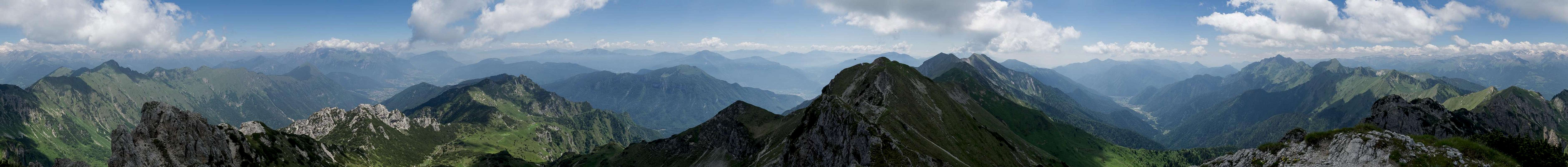
On a good day the mountains offers good views, which thanks to the proximity, are dominated by the Adamello-, Brenta- and Bondone-Groups in the north.
360° Summit Panorama
  |
Getting There
 Monte Cadria seen across Valle di Concei
There are three trailheads for Dosso della Torta, Malga Trat, Malga Pranzo and the village Ballino.
- Malga Trat
- On Brenner Motorway A22 take the exit Roveretto Sud
- Switch to SS240 to Riva del Garda
- After the town follow the signs to Valle di Ledro still remaining on SS240.
- Drive through two tunnels and after Pieve di Ledro switch to SP119 into Valle Concei
- At the end of the village Lenzumo turn right onto a mountain road to Malga Trat. It ends some 800m before the farm.
- Malga Pranzo
- On Brenner Motorway A22 take the exit Roveretto Sud
- Switch to SS240 to Riva del Garda
- After the town switch to SP37 to Pranzo
- Turn left onto SP37dir to Campi
- Take the dirt road to Malga Pranzo
- Ballino
- On Brenner Motorway A22 take the exit Roveretto Sud
- Switch to SS240 to Riva del Garda
- After the town switch to SP37 to Pranzo and SS421 to Ballino
Red Tape
 Viola calcerata
There's no Red Tape, perhaps a bit of private property around the farms but otherwise unspoilt. The WW I trails have been renovated recently(?), try to keep themin shape.
When to Climb
The best time is early summer through late autumn.Accommodation
Weather Conditions
Maps & Books
Maps
- Digital Maps
- Regular Maps
- Alto Garda - Ledro - Monte Baldo
Tabacco Map 061
Editione Tabacco
1:25000
ISBN: 978-8883151057
- Alto Garda - Ledro - Valle del Sarca
Kompass Map WK096
Kompass Verlag
1:250000
ISBN: 978-3850264921
- Alto Garda e Ledro
Kompass Map WK690
Kompass Verlag
1:250000
ISBN: 978-3854917724
- Alto Garda - Ledro - Monte Baldo
Books
- Gardaseeberge
Heinrich Bauregger
Rother Verlag
ISBN: 978-3-7633-4256-3