
|
|
Mountain/Rock |
|---|---|
|
|
45.96639°N / 10.76322°E |
|
|
Trentino |
|
|
Mountaineering |
|
|
Spring, Summer, Fall |
|
|
6716 ft / 2047 m |
|
|
Overview
Monte Gavardina 2047 m
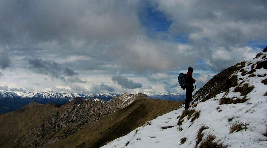
Monte Gavardina 2047 m belongs to the Prealpi Bresciane e Gardesane, subgroup Alpi di Ledro. It is also called Gaverdina and Cima Polester and is not a particularly flashy summit, but an important orographic junction, where Monte Altissimo high ridges coming from the North join the Pichea ridge coming from the South-East and Cadria ridges coming from the South-West. The Normal route of ascent to the top is a fine hike in the lonely setting of Val Concei. Like most of the peaks in the Alpi di Ledro, it was scenery of long fighting during the WWI, in reason of being located close to the borders between the Kingdom of Italy and the Austro-Hungarian Empire, so on Gavardina and surroundings there are numerous remains of fortifications, in this case built by the Austrian troops, because the mountain was situated in the territories of the empire. Due to the altitude and the location, the summit offers a wide panorama over Carè Alto, Presanella and Brenta Dolomites.
Il Monte Gavardina 2047 m appartiene alle Prealpi Bresciane e Gardesane, sottogruppo Alpi di Ledro, ed è chiamato anche Gaverdina e Cima Polester. Non è una vetta particolarmente appariscente, ma un importante nodo orografico, dove le elevate creste settentrionali del Monte Altissimo si uniscono alla Cresta di Pichea proveniente da sud-est e alla cresta di Cadria proveniente da sud-ovest. La via normale di salita alla cima è una bella escursione nella solitaria cornice della Val Concei. Come la maggior parte delle cime delle Alpi di Ledro, scenario di lunghi combattimenti durante la I guerra mondiale, per il fatto di essere situate vicino ai confini tra Regno d'Italia e Impero Austro-ungarico, sul Gavardina e montagne circostanti si trovano numerosi resti di fortificazioni.Nel caso del Gavardina si tratta di fortificazioni costruite dagli Austriaci, in quanto la montagna era situata nei territori dell'impero. Per l'altitudine e della posizione, la cima offre un ampio panorama su Carè Alto, Presanella e Dolomiti di Brenta.

Getting There
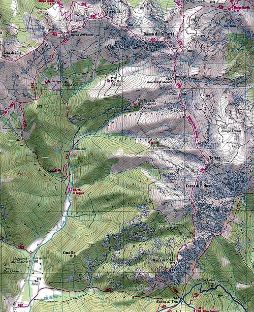
The starting point to climb Gavardina Normal route is Rifugio "Al Faggio" 963 m.
Access: from the Brennero autoroute exit Rovereto Sud and take the road to Riva del Garda. From here follow the road to Val di Ledro; after the tuunel the road enters the valley, skirting the Lago di Ledro. Reach Pieve di Ledro, located at the end of the lake, continue to Bezzecca and just before the village on the right there's is a junction signposted Val Concei. Leave the main road and turn to right to Val Concei, following the road up to its end, where we leave the car at the characteristic Rifugio "Al Faggio" 963 m.
Route: Monte Gavardina from Rifugio Al Faggio

Gavardina Normal route from Rifugio "Al Faggio"
Summit quote: 2047 m
Difficulty: EE
Difference in level: 750 m from Pregasina
Exposition: North, NE, West
Time required: 4 hours to Cima Al Bal reversing the same route, 6 hours round trip
Starting point: Rifugio Al Faggio m 963
From Rifugio Al Faggio follow the track SAT 414 along the Lomar Valley, crossing soon the Glera Bridge over the Assat stream and ending at 1120 m, where it becomes a path that follows the river. Then you enter into a rocky ravine and walk up the "Scale del Guì". After about 1 hour from the start, the path gets Malga Guì m. 1444, from which it continues on the left of the alp in the wood, reaching the meadows of the pass named Sella del Dos de Lomar 1.597 m. The pass in question allows you to look westward observing for the first time the highest peak of the Ledro Alps: Monte Cadria. After crossing the lawn we get an important signposted junction. Ignore the path 452 that would lead to Baita Lomar and turn instead to the right (NE), keeping the 414 trail and following the clear signposts to Bocca dell'Ussol.

|

|

|

|

|

|
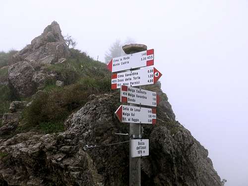
Now the itinerary enters the wood again for a short distance, then exits onto the open ground on a scenic trail, that follows the NE direction, crossing the hillside along Corno del Guì. In the distance it appears a series of rocky pinnacles overlooking our route from the left, on one of which it's located a cross. Towards right it appears a long ridge reaching es its highlights in the summits of Tofino and Corni di Pichea. Two options can be chosen to get the col, because the two paths are rejoining just above. The last part of the path, skirting some cliffs, is definitely steepening, getting the Bocca dell'Ussol 1895 m, a narrow rocky notch between Corno del Guì and Gavardina (1 hours from Sella di Lomar, 2.45 hours from the start). From this point it's worthwhile to do a short detour to the left, to climb up towards Dente dell'Ussol 1940 m. and observe the WWI reamains just seen in the distance and visit the Chiesetta della Pace, built using the remains of the military post. We reverse the short variant, getting again the col and turn to right (signposts Gavardina). We face now the highlight of the itinerary: the beautiful ridge rising Eastward from Bocca dell'Ussol, in the direction of Gavardina and Dosso della Torta. The path 455 follows mostly the ridge overlooking both sides. Along the ridge we can see other WWI remains.

|

|

|
After overcoming a short rocky gap, we walk up a steep stretch of the ridge getting a prominence of the ridge with as scenic cairn. We notice, at a short distance, the summit of Gavardina. To reach the summit lose altitude for a few minutes, then up to a saddle and along the well worn path which gains the summit (0.30 hours from Bocca dell'Ussol, 3.30 hours from the start). Wide views to Monte Cadria, Adamello Group and also Brenta Dolomites, with the summit plateau of Cima Tosa.
Descent - Reverse the same route as far as Sella di Lomar. Once at Sella di Lomar, it's possible the chose the other trail (SAT 414b) to descend to Rifugio Al Faggio along a different itinerary.
Italian version
Dal Rifugio Al Faggio seguire una sterrata (SAT 414) lungo la valle del Lomar, che attraversa subito il ponte Glera sul torrente Assat e termina a 1120 m, dove diventa un sentiero che costeggia il fiume. Quindi si entra in una gola rocciosa e si sale la "Scala del Guì". Dopo circa 1 ora dall'inizio, il sentiero raggiunge Malga Guì m. 1444, da dove si prosegue bel bosco a sinistra dell'alpeggio, raggiungendo i prati del passo denominato Sella del Dos de Lomar 1597 m. Dal passo in direzione Ovest si può osservare per la prima volta la vetta più alta delle Alpi di Ledro: il Monte Cadria. Dopo aver attraversato il prato si giunge ad un importante incrocio segnalato. Lasciato il sentiero 452 che porta a Baita Lomar si svolta invece a destra (NE), mantenendosi sul sentiero 414 e seguendo le indicazioni per Bocca dell'Ussol. Ora l'itinerario rientra nuovamente nel bosco per un breve tratto, quindi esce sul terreno aperto su un sentiero panoramico in direzione nord-est, che attraversa il pendio lungo il Corno del Guì. In lontananza appare una serie di pinnacoli rocciosi che dominano da sinistra il nostro percorso, su uno dei quali è situata una croce. Verso destra appare una lunga dorsale che raggiunge i suoi punti più elevati nelle vette del Tofino e dei Corni di Pichea. Per raggiungere il colle vi sono due possibilità; comunque i due percorsi si ricongiungono appena sopra. L'ultimo ripido tratto del sentiero costeggia alcune pareti e raggiunge la Bocca dell'Ussol 1895 m, una stretto intaglio roccioso tra Corno del Guì e Gavardina (1 ora da Sella di Lomar, 2.45 ore dall'inizio).
Da questo punto vale la pena fare una breve deviazione a sinistra per salire verso il Dente dell'Ussol 1940 m. e osservare i resti della I guerra mondiale appena visti in lontananza e visitare la Chiesetta della Pace, costruita utilizzando i resti della postazione militare. Ritornati al colle, riprendiamo l'itinerario per il Gavardina svoltando a destra (indicazioni Gavardina). Affrontiamo ora il tratto clou dell'itinerario: la bellissima cresta che sale verso est da Bocca dell'Ussol, in direzione di Gavardina e Dosso della Torta. Il percorso 455 segue principalmente la cresta che domina entrambi i lati. Lungo la cresta possiamo vedere altri resti della I guerra mondiale.
Dopo aver superato una breve spaccatura rocciosa, camminiamo su un ripido tratto della cresta raggiungendo un risalto lungo la cresta con un grande ometto. Notiamo, a breve distanza, la punta del Gavardina. Per raggiungere la vetta si perde quota per alcuni minuti, quindi si sale a una sella lungo il sentiero ben tracciato che guadagna la vetta (0,30 ore da Bocca dell'Ussol, 3,30 ore dall'inizio). Ampia vista sul Monte Cadria, sul Gruppo Adamello e anche sulle Dolomiti di Brenta, con l'altopiano della Cima Tosa.
Discesa - Seguire lo stesso percorso fino a Sella di Lomar. Una volta giunti a Sella di Lomar, è possibile scegliere il sentiero sulla destra (SAT 414b) per ridiscendere al Rifugio Al Faggio.
Hiking and scrambling scale
ENGLISH VERSION
T - Turistico (Tourist): Itineraries on wide, clear and well worn paths, sometimes on mule tracks or gravel roads. The routes are never exposed, don't give any orientation problems and don't exceed 2500 meters of altitude. Suitable also for children
E - Escursionisti (Hikers): Itineraries on marked trails, even narrow and with possible steep and impervious sections. They are never exposed and don't give any orientation problems. They can tread different kinds of ground, such as forests, gravel, meadows, pastures, easy rocks, etc.). They form the majority of the trails that wind up in the mountains and require a certain habit to walk; you need equipment suitable for the altitude and resistant footwear with soles suitable for rough terrain
EE - Escursionisti Esperti (Experienced Hikers): Itineraries for hikers with experience and good knowledge of the mountain. Some of these paths may have exposed sections, however brief, which require firm foot and no dizziness. They require the ability to adapt to particular terrain, such as steep grassy slopes or stretches of rocks with difficulties that can reach the 1st degree of the UIAA scale. They can also reach high altitudes (3000 m or more). Sometimes they may include unmarked sections, requiring a good sense of orientation. Snow slopes are possible, however which can be overcome without specific mountaineering gear (rope, harness, crampons, ice-axe)
EEA - Escursionisti Esperti con Attrezzatura (Experienced Hikers with equipment) - The same as EE, in addition these routes require the use of via ferrata equipment (lanyards, harness, carabiners, heat sink, helmet). This kind of itineraries range from the trails with short easy and not much exposed sections, previously equipped with fixed ropes and iron pegs, to the true and more difficult Via Ferratas climbing on rocky walls or on aerial ridges and ledges, previously equipped with long stretches of iron ropes, iron steps, ladders without which proceeding would constitute a real climbing. It is necessary to know how to use the technical equipment and have a certain habit of exposure and mountaineering terrains.
VERSIONE ITALIANA
T - Turistico: itinerari su sentieri ampi, evidenti e ben tracciati, a volte su mulattiere o strade sterrate. I percorsi non sono mai esposti, non danno problemi di orientamento e non superano i 2500 metri di altitudine. Adatti anche ai bambini
E - Escursionisti: itinerari su sentieri segnalati, anche stretti e con possibili tratti ripidi e impervi. Non sono mai esposti e non danno problemi di orientamento. Possono percorrere diversi tipi di terreno, come foreste, ghiaioni, prati, pascoli, facili rocce, ecc.). Costituiscono la maggior parte dei sentieri che si possono incontrare in montagna e richiedono una certa abitudine a camminare. Richiedono inoltre un equipaggiamento adatto all'altitudine e calzature resistenti con suole idoneee ai terreni accidentati
EE - Escursionisti Esperti: itinerari per escursionisti con esperienza e buona conoscenza della montagna. Alcuni di questi percorsi possono presentare sezioni esposte, per quanto brevi, che richiedono piede fermo e assenza di vertigini. Richiedono la capacità di adattarsi a terreni particolari, come ripidi pendii erbosi o tratti rocciosi con difficoltà che possono raggiungere il I grado della scala UIAA. Possono anche raggiungere quote elevate (3000 m o più). A volte possono prevedere tratti non segnalati, che richiedono un buon senso dell'orientamento. Sono possibili pendii nevosi, che possono essere superati senza attrezzatura specifica per l'alpinismo (come corda, imbragatura, ramponi, piccozza)
EEA - Escursionisti Esperti con Attrezzatura - Come l'EE, in più questi percorsi richiedono l'uso di attrezzatura da via ferrata (cordini, imbragatura, moschettoni, dissipatore di calore, casco). Questo tipo di itinerari spazia dai sentieri con brevi tratti facili e poco esposti, dotati di corde fisse e/o pioli di ferro, verso le vere e più difficili Vie Ferrate che affrontano pareti rocciose o creste aeree, dotate di lunghi tratti di corde fisse generalmente in acciaio, gradini di ferro e/o scale senza cui la progressione diventerebbe una vera e propria scalata. È necessario essere a conoscenza delle modalità di utilizzo dell'attrezzatura tecnica e avere una certa abitudine all'esposizione e ai terreni alpinistici.
Red Tape
No permits, no fees required.
When to Climb
Best seasons are Spring, Summer and Autumn. In wintertime only in absence of snow and ice.

|

|
, Bocca dell'Ussol")
|
Accomodation
Otherwise there are wide possibilities of accomodation in Val di Ledro
Bibliography
"Prealpi Bresciane" by Fausto Camerini - Collana Guide dei Monti d'Italia, CAI-TCI
Maps:
KOMPASS sheeet 071 – Alpi di Ledro Valli Giudicarie 1:50.000 LAGIRALPINA sheet 016 - Alpi di Ledro - Tremalzo 1:25.000