
|
|
Mountain/Rock |
|---|---|
|
|
45.81046°N / 10.41103°E |
|
|
Lombardy |
|
|
Hiking, Mountaineering, Trad Climbing, Ice Climbing |
|
|
Spring, Summer, Fall, Winter |
|
|
6772 ft / 2064 m |
|
|
Overview
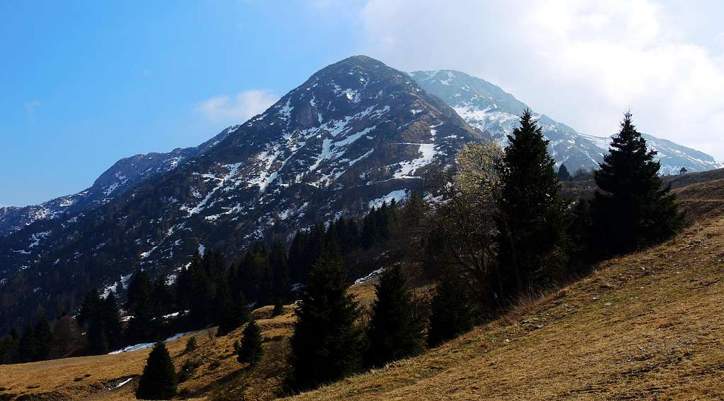
Dosso Alto 2064 m
Dosso Alto 2064 m is the highest and Northernmost mountain in the chain named Piccole Dolomiti Bresciane, located in a large area of the Brescia province and belonging to the Prealpi Bresciane e Gardesane. The Piccole Dolomiti Bresciane lie at the head of Val Trompia, immediately Southeast to the Passo Maniva, a road col between Valle Caffaro and Val Trompia. Their name is due to the limestone outcrops which characterize these mountains, which recalls the type of rock of the Dolomites. Dosso Alto dominates the Giogo del Maniva 1664 m and is a majestic mountain rising on the Northern side with steep rocky walls crossed by gorges, which in wintertime become interesting snow and ice gullies. In summer, the Normal route from Giogo del Maniva is an easy climb on well worn trails, while in wintertime it turns into a beautiful snowy crests often bordered by frames. Dosso Alto offers a broad panorama, one of the most spectacular of Piccole Dolomiti Bresciane: to the North it appears the magnificent view of the Adamello Group, to the West the Orobie Alps, to the South the landscape is dominated by the Corna Blacca and Cima Caldoline, while to the East the mountains surrounding the Garda lake with the long ridge of Monte Baldo.
Getting There
There are some different standard routes to summit Dosso Alto: the shortest one starts from Giogo del Maniva, a road col between Valle Caffaro and Val Trompia, while it exists another route, much longer and with more considerable difference in level, but much more interesting, which starts from the side of Bagolino. The two routes can be combined into a very interesting ring itinerary.
The nearest village to climb the mountain is Bagolino 778 m., a fine tourist center located in Val Sabbia with a pleasant medieval aspect.
Road access to Bagolino
- From the town of Brescia take the Southern ring road south towards Lago di Garda, after about 10 km take the exit towards Salò, continue on the ring road until you enter the direction to Madonna di Campiglio and Trento. Pass the villages of Vobarno, Sabbio, Chiese, Vestone, Idro and Anfo and after about 5 km from Anfo turn left and continue for about 10 km to Bagolino (80 km from Brescia).
Road access from Bagolino to Giogo del Maniva and Pissisidol
Giogo del Maniva - From the village of Bagolino take the road to Giogo del Maniva. The road diverges from of the road to Crocedomini in two different places, South of the town of Bagolino (Ponte Prada, industrial area) or North of Bagolino. The road rises steeply to the Giogo del Maniva Pass (15 km. from Bagolino).
Pissisidol - Once taken the road to Giogo del Maniva in Bagolino, after about 8 km, at the intersection of Pissisidol, turn left and continue until you reach a bridge on the road, the Recicandè Bridge. Here it starts the itinerary to Dosso Alto (pole with signpost, n. 407 Var).
Route: Dosso Alto Normal route via Passo del Dosso Alto
Dosso Alto Normal route via Passo del Dosso Alto (SW ridge)
Summit quote: 2064 m
Difficulty: EE, F in winter
Difference in level: 400 m from Giogo del Maniva
Exposition: South-West
Starting point: Giogo del Maniva 1664 m

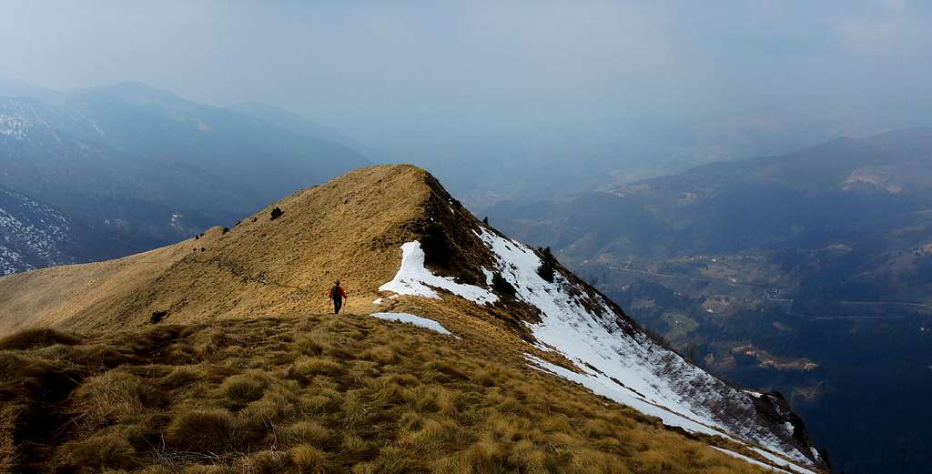
The itinerary starts from Passo del Dosso Alto 1727 m. To reach this pass take the road (SP Giogo Maniva - Baremone - Anfo) starting from Giogo del Maniva and leading to Passo del Dosso Alto 1727 m, a road pass accessible by car exclusively in summer, while in spring and winter the road is covered by the snow - avalanches descending from the slopes. From this col take on the left the SW ridge on a path marked with blue marks (3V or Three Valleys path). The trail goes up the grassy slopes that lead to the SW crest and follows the ridge remaining on the S side of Dosso Alto. After crossing a short slope to the right, continue along the ridge, interrupted towards the end from some WWI rocky holes, getting the summit metal cross (summit book).
Descent: reversing the route
Route: Dosso Alto crossing from Pissisidol
Dosso Alto crossing from Pissisidol
Summit quote: 2064 m
Difficulty: EE
Difference in level: 980 m from Rio Recicandè Bridge
Exposition: North, then East
Starting point: Rio Recicandè Bridge 1086 m


From the Recicandè Bridge take on the right the forest road just near the road bridge (signpost "Dosso Alto", path n. 407/var.). Don't misunderstand and don't take with the nearby forest road that starts a few meters further to the right, this is the path leading to Giogo del Maniva. Going along the forest road, after a few steps, you cross the river and reach a bar closing the forest road. Ignore another forest road on the right and near the bar turn to right on a narrow path rising steeply across the woods. The trail rises and further up returns on the forest road. Take the forest road to the right and continuing you get, shortly before its end, a poorly visible crossroads with a narrow path on the left, marked with a pole. Here you must leave the forest road and turn to left on the narrow track.

|

|

|

|

|

|
The path rises and traverses in the forest for a long time to the left on the W of Roccolo Campadello, then the path goes up a steeper stretch, always within the dense forest, and finally it exits the wood (signposts "Dosso Alto" and "Pissisidol") to a saddle on a ridge which traverses to the right. From here you can just see the top of Dosso Alto. From the saddle follow the well worn path crossing a steep grassy slope in a beautiful landscape, during which the spring is dotted with magnificent flowering of crocuses and heather. Further up the trail makes a sharp right turn and soon head to the left again to enter a valloon just above some pastures abandoned. Continue steeply uphill amongst low vegetation and scree in the direction of the clearly visible East ridge, which is reached in ascent from the valloon. After getting the ridge with beautiful views to the steep northern face of Dosso Alto continue uphill and reach the saddle at the altitude of 1923 (blue signals). From here continue again uphill along the ridge getting quickly the panoramic summit cross.

|

|

|
Descent: take the SW ridge on the opposite side of the climb up and follow it, easily getting Passo del Dosso Alto 1727 m. From here turn to right along the road leading to Giogo del Maniva. Cross the large square behinf the huts an take just only for a few meters the road to Bagolino, in fact you can descend along the slope taking as reference the direction of the double-lift. The slope falls on the asphalt road, cross it and continue along the meadows crossing the asphalt road a few times, reaching the Fabus Hut, from which it starts the mule track n. 407 leading near the bridge Pissisidolo where we started.
Route: Dosso Alto NNW ridge
Dosso Alto NNW ridge
Summit quote: 2064 m
Difficulty: EEA without snow, in winter the route becomes a mixed climb graded AD inf.
Difference in level: 400 m from Giogo del Maniva
Exposition: NNW
Starting point: Giogo del Maniva 1664 m

From the car park at the church of Passo Maniva continue for about 20 meters on the road behind the church, then leave it and take the obvious ridge, at first grassy. The ascent follows the whole ridge, in some points marked with blue stamps. The initial part of the ridge is gentle angled and large, then the slope increases and deflects on the left side. The route follows a steep slope up to reach again the ridge above a wall with pines. Now it follows the ridge, climbs a rocky outcrop of a few meters - it's possible to wander to the left - and continues on the ridge sometimes narrow and sharp. The route gets an easy rocky stretch (I+), if it's snow-covered it's better to fit out a belay on a hole, or put a friend. Exit on the ridge and follow it, sharp again, then wider. After reaching the top of the fore-summit, downclimb to a saddle from which you climb a hill; from the top of the hill the route descends again to another saddle before a big squared rock. From here you have the chance to escape down to the right in the Grand Gully and return to the road below, in case of bad snow conditions. From the saddle up the wide ridge, descend to another saddle and follow the rocky ridge, reaching the summit slope, leading to a signal along the East ridge. Following the East ridge rightward you will briefly reach the summit cross.
Descent: from the summit cross take to the right the SW ridge and follow it, easily getting Passo del Dosso Alto 1727 m. From here turn to right along the road leading to Giogo del Maniva.
Red Tape
There are not special restrictions in climbing, hiking and mountaineering.
")
|
|
")
|
Hiking and scrambling grades of difficulty
T - Turistico (Tourist): Itineraries on wide, clear and well worn paths, sometimes on mule tracks or gravel roads. The routes are never exposed, don't give any orientation problems and don't exceed 2500 meters of altitude. Suitable also for children.
E - Escursionisti (Hikers): Itineraries on marked trails, even narrow and with possible steep and impervious sections. They are never exposed and don't give any orientation problems. They can tread different kinds of ground, such as forests, gravel, meadows, pastures, easy rocks, etc.). They form the majority of the trails that wind up in the mountains and require a certain habit to walk; you need equipment suitable for the altitude and resistant footwear with soles suitable for rough terrain.
EE - Escursionisti Esperti (Experienced Hikers): Itineraries for hikers with experience and good knowledge of the mountain. Some of these paths may have exposed sections, however brief, which require firm foot and no dizziness. They require the ability to adapt to particular terrain, such as steep grassy slopes or stretches of rocks with difficulties that can reach the 1st degree of the UIAA scale. They can also reach high altitudes (3000 m or more). Sometimes they may include unmarked sections, requiring a good sense of orientation. Snow slopes are possible, however which can be overcome without specific mountaineering gear (rope, harness, crampons, ice-axe).
EEA - Escursionisti Esperti con Attrezzatura (Experienced Hikers with equipment - The same as EE, in addition these routes require the use of via ferrata equipment (lanyards, harness, carabiners, heat sink, helmet). This kind of itineraries range from the trails with short easy and not much exposed sections, previously equipped with fixed ropes and iron pegs, to the true and more difficult Via Ferratas climbing on rocky walls or on aerial ridges and ledges, previously equipped with long stretches of iron ropes, iron steps, ladders without which proceeding would constitute a real climbing. It is necessary to know how to use the technical equipment and have a certain habit of exposure and mountaineering terrains.
Nature and history
The Maniva-Crocedomini ridge, during the First World War, formed the third defensive line of the main line known as "barring Giudicarie". In addition to the indisputable beauty of the natural setting is certainly important to mention the great flora richness of this area, having a remarkable amount of rare alpine plants, many of which endemic.
When to Climb
All year round for the itinerary 1 and 3, but in winter you must plan the ascent only after having verifyed the good conditions of the mountain, the presence of stable snow and the absence of danger of avalanches. The itinerary 2 from Pissisidol is advisable only from mid April to mid November.
Accomodation
Different possibilities in Bagolino (hotel, bed and breakfast and camping) and Giogo del Maniva (huts).
Bibliography
"Prealpi Bresciane" by Fausto Camerini - Collana Guide dei Monti d'Italia, CAI-TCI
"Le Tre Valli Bresciane" - KOMPASS N. 103 - 1:50000