
-
 5417 Hits
-
 86.37% Score
-
 22 Votes
|
|
Mountain/Rock |
|---|---|
|
|
45.91840°N / 10.76740°E |
|
|
Trentino Alto-Adige |
|
|
Hiking, Ice Climbing, Scrambling, Skiing |
|
|
Spring, Summer, Fall, Winter |
|
|
6532 ft / 1991 m |
|
|
Overview
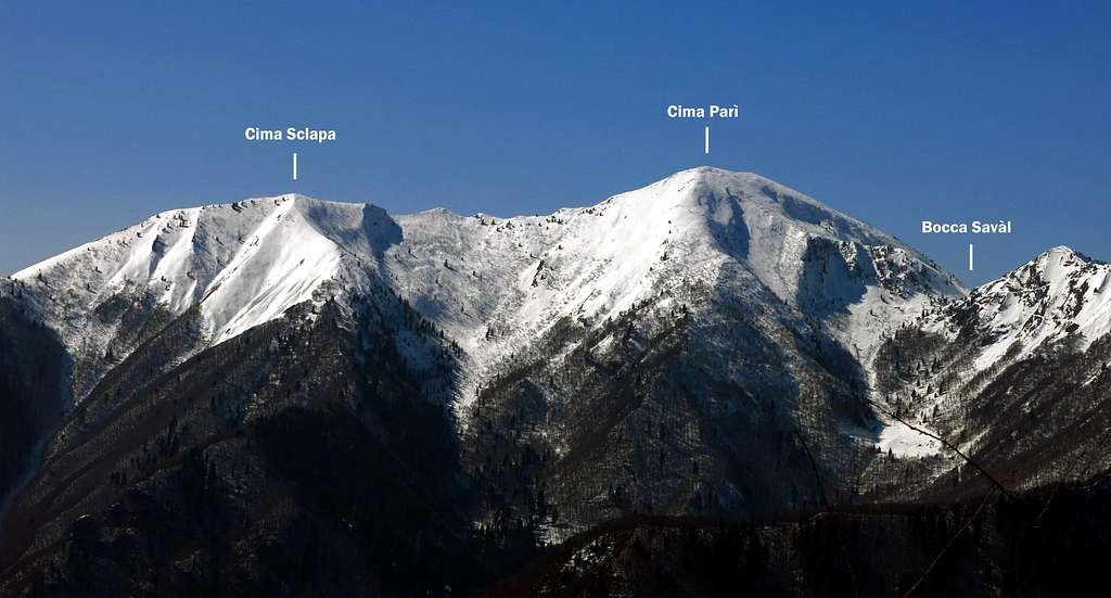
Cima Parì m. 1991
Cima Parì m. 1991 is a montain belonging to the Prealpi Bresciane and Gardesane, Alpi di Ledro Subgroup, the varied pre-Alpine area that acts as a buffer between the Garda territories, which enjoy a semi-Mediterranean climate, and the alpine high mountains of the Adamello group. Cima Parì overlooks the Lago di Ledro in the homonymous valley. It's a little-known mountain, located on the left bank of the Val di Ledro, often climbed in succession with the nearby Cima Sclapa.
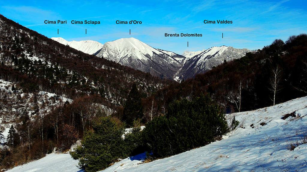
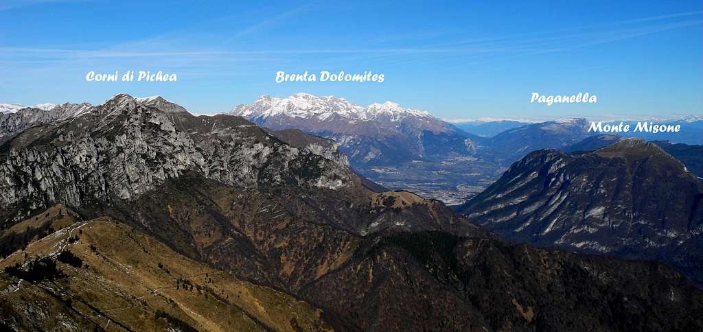
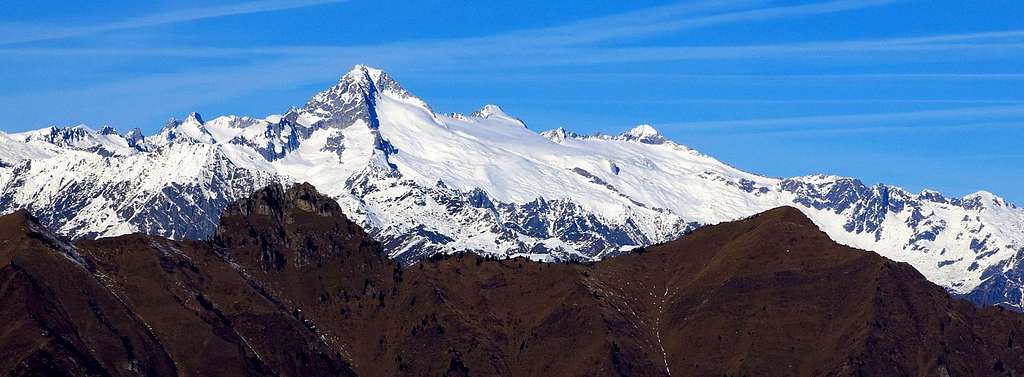
Cima Parì combines the beauty of the route to a vast landscape, that is truly exceptional, in reason of the central position of the mountain. The views are extending themselves from the Verona plain (Po Valley) to the pre-Alpine mountains located around Garda and Ledro lakes, the Sella group, the Brenta Dolomites, and the high peaks of the Adamello and Presanella groups. The panorama over the 360° horizon is really great!
The mountain is located within an area that was the scene of fighting between the Austrians and the Italians during the WWI, because here it ran the border between the Kingdom of Italy and the Austro-Hungarian Empire and here it ran the first line of the two opposing forces.


The itinerary proceeds among the testimonies of WWI, like barracks, fortifications, deposits, trenches. These latter can be observed even along the summit ridge joining Cima Parì and Cima Sclapa, a second summit which can be conveniently linked with the previous one: another reason of interest to climb this summit, together with the really lush alpine wild flowers, that can be found in late spring or early summer.
Getting There
The starting point to climb the mountain is Bocca di Trat, m. 1587.
Access: from the Brennero autoroute exit Rovereto Sud and take the road to Riva del Garda. From here follow the road to Val di Ledro, pass the tunnel, entering the valley and skirting the Lago di Ledro. Reach Pieve di Ledro, located at the end of the lake, where you must leave the main road and turn to right to Val Concei, getting to the small village of Lenzumo. At the end of Lenzumo turn to right again (signposts Rif. Nino Pernici), taking a 7 km. mountain road which rises with several hairpins to Malga Trat m. 1502 (about 50 km from Rovereto). The road is closed in its last 500 meters, so leave your car in an obvious pull-out on the right side of the road.


An alternative way to reach Bocca di Trat is starting from Malga Grassi m. 1056, which can be approached by car from the settlement of Campi, nearby Riva del Garda. This second possibility involves a significant increase in the level difference. Will be described the shorter ascent starting from the Val di Concei side.
Route: Cima Parì - Cima Sclapa traverse
Cima Parì - Cima Sclapa traverse
Difficulty: F (Alpine scale) in winter condition, otherwise EE
Difference in level: 500 m from the road to Malga Trat
From the parking continue on the dirty road reaching the alp called Malga Trat m. 1502 in a few minutes. Take the path 413 rising inside the wood and getting to the large saddle of Bocca di Trat m. 1587. Turn to right to reach soon the Nino Pernici shelter m. 1601 (20 minutes from Malga Trat), lying in a fine location with good views to the rocky summit of Mazza di Pichea and Lago di Garda. Continue beyond the hut, following the level path 413 that traverse the Dorsale di Seaoi along a slope at first wooded, then grassy, to arrive ahead of the barracks of the First World War dominated by the imposing Cima Parì.


From the barracks turn immediately to right, getting to Bocca Savàl m. 1740 in 1 minute (1 hour from the hut Nino Pernici). At the pass, near a tiny pond surrounded by a fence, turn sharply to the left to follow a trail that goes at first directly along the Western slopes of the mountain, then with a long diagonal upward to the right reaches a shoulder - little cairn – at the base of the ridge that rises towards the summit.
We walk along this ridge with superb views over Lago di Ledro just on the right below us, reaching the summit cross.


The view is superb on Ledro Lake, Garda Lake, Monte Stivo, Monte Bondone and Monte Altissimo di Nago to the right, the Sella Group and the Brenta Dolomites to the North, the nearby and wild Monte Cadria and the superb coastline of the Adamello-Presanella range to the West.
Descent - - The descent is done along the same route to Bocca Saval. A second longer but very advisable possibility is to continue to the south east along the summit ridge, with clear remains of the WWI trenches, along a path mainly downhill, with only a last brief ascents to reach the nearby Cima Sclapa m. 1860.


From the summit of Cima Sclapa descend to the North along a steep slope to gain the level path skirting the North sides of the mountains and reach the WWI barracks on Bocca Saval. At this point you can follow an alternative route in order to make a complete ring without ever returning on the upward itinerary. Reach the small pond near Bocca Saval lying below the West side of Cima Parì. Just in front of it take the right path that - after gaining with a short climb a grassy ridge - descends on the wooden opposite side. From here a good trail reachs directly Malga Trat.
Red Tape
No fees no permits required. Cars are not allowed in the last 1 km of the road to Malga Trat.
Hiking and scrambling scale
T - Turistico (Tourist): Itineraries on wide, clear and well worn paths, sometimes on mule tracks or gravel roads. The routes are never exposed, don't give any orientation problems and don't exceed 2500 meters of altitude. Suitable also for children
E - Escursionisti (Hikers): Itineraries on marked trails, even narrow and with possible steep and impervious sections. They are never exposed and don't give any orientation problems. They can tread different kinds of ground, such as forests, gravel, meadows, pastures, easy rocks, etc.). They form the majority of the trails that wind up in the mountains and require a certain habit to walk; you need equipment suitable for the altitude and resistant footwear with soles suitable for rough terrain
EE - Escursionisti Esperti (Experienced Hikers): Itineraries for hikers with experience and good knowledge of the mountain. Some of these paths may have exposed sections, however brief, which require firm foot and no dizziness. They require the ability to adapt to particular terrain, such as steep grassy slopes or stretches of rocks with difficulties that can reach the 1st degree of the UIAA scale. They can also reach high altitudes (3000 m or more). Sometimes they may include unmarked sections, requiring a good sense of orientation. Snow slopes are possible, however which can be overcome without specific mountaineering gear (rope, harness, crampons, ice-axe)
EEA - Escursionisti Esperti con Attrezzatura (Experienced Hikers with equipment - The same as EE, in addition these routes require the use of via ferrata equipment (lanyards, harness, carabiners, heat sink, helmet). This kind of itineraries range from the trails with short easy and not much exposed sections, previously equipped with fixed ropes and iron pegs, to the true and more difficult Via Ferratas climbing on rocky walls or on aerial ridges and ledges, previously equipped with long stretches of iron ropes, iron steps, ladders without which proceeding would constitute a real climbing. It is necessary to know how to use the technical equipment and have a certain habit of exposure and mountaineering terrains.
Essential gear
In wintertime, according with the conditions, crampons and axe are necessary
Accomodation
Different possibilities of accomodation in Val di Ledro


Along the route we find the Rifugio Nino Pernici m. 1601
When to Climb
All year round – In winter conditions the climb requires the use of axe and crampons
Meteo
Guidebooks and maps


- "Prealpi Bresciane" by Fausto Camerini - Collana Guide dei Monti d'Italia, CAI-TCI
- "Guida alle Alpi di Ledro by F. Torchio - E. Gardumi, Panorama, Trento, 1995
- Garda-Trentino map scale 1:30.000
- Alto Garda e Ledro map scale 1:25000, Kompass