
|
|
Mountain/Rock |
|---|---|
|
|
45.88350°N / 10.80805°E |
|
|
Trentino Alto-Adige |
|
|
Hiking, Scrambling |
|
|
Spring, Fall |
|
|
5052 ft / 1540 m |
|
|
Overview
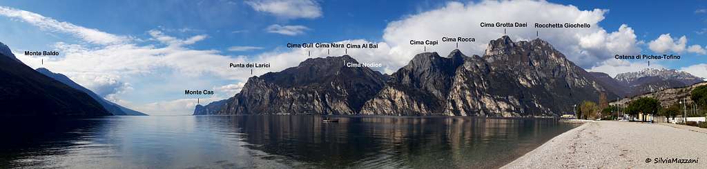
Rocchetta Giochello m. 1540
Rocchetta Giochello 1540 m is a wild and secluded rocky summit belonging to the Prealpi Bresciane e Gardesane, overlooking the village of Biacesa in Val di Ledro and dominating the Garda Lake with exceptional views. More precisely, the peak belongs to the group of Rocchetta, a small area consisting of a group of rugged peaks, incumbent on Garda Lake and Riva del Garda. The East side, the one facing the lake, is the most austere, made up of rocky cliffs furrowed by deep gullies. Rocchetta Giochello is located in the middle of the group and connected to the other summits by a network of paths for experts.
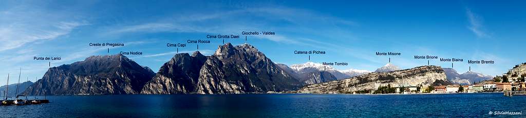
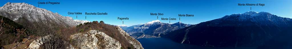
Apart from the breathtaking summit views over the mountains surrounding Garda Lake towards East, Adamello, Presanella and Brenta Dolomites towards West and farther the Northern Dolomites with Sella Group, this mountain is really interesting to discover the important and well preserved remains of the First World War. The mountain was a strategic point on the whole Garda Lake area already during the Serenissima; during the Great War was structurally fortified by the Austro-Hungarians along all the ridges and slopes. On the summit there was the observatory, many gun emplacements, caves, bunkers and shelters, all connected by a network of trenches.

|

|
The guns located on the summit supported the movements on the battlefields of the whole area and struck the Italian military posts on Cima Al Bal, Cima Nodice and Monte Carone. The remains of that parade still surrounds the visitor. The recent opening of the path "Rino Zanotti" which takes place along the summit ridge from Bochet dei Concolì passing through several WWI remains, as caves, artifacts and trenches makes even more spectacular and interesting the itinerary. It's to point out the botanical interest with the presence along the route of many species of flowers, including the rare "Viola Pennata".
Getting There
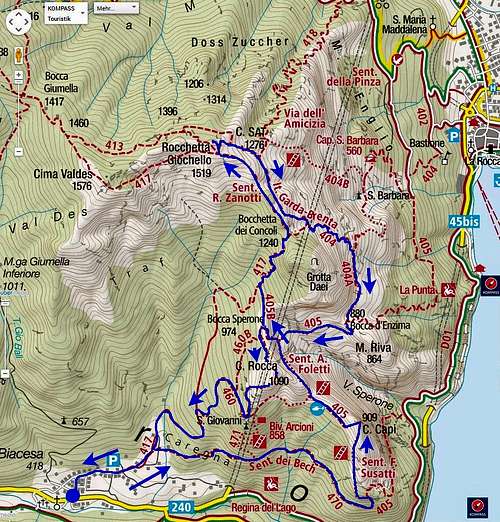
Access: from the Brennero autoroute exit Rovereto Sud and take the road to Riva del Garda. From here follow the road to Val di Ledro, leading through a tunnel to the small village of Biacesa di Ledro m. 418, the starting point of the itinerary.

|

|
Route: Rocchetta Giochello from Biacesa di Ledro
Rocchetta Giochello Normal route from Biacesa di Ledro
Summit quote: 1540 m
Difficulty: EE
Difference in level: 1155 m from Biacesa di Ledro
Exposition: South-East
Time required: 6 hours round trip
Starting point: Biacesa di Ledro m 422
The proposed itinerary has a strong historical character as it links the various forts, caves and buildings dating from the World War I.

|

|

|

|

|

|
Route description
Reached the only traffic lights in the village of Biacesa turn to right and follow the signposts to Cima Capi and Cima Rocca, leaving your car in a large parking. We walk briefly among the houses of the village, reaching a fork near a fountain, where on the right we find again the Club Alpino Italiano red and white signpost. Here we take the right track that goes up through the last houses of the village, reaching a second fork. We leave on the right the path to Cima Capi (Sentiero del Bech, n. 470) and continue straight along the path 417 that enters the woods, following the signpost to the Bochet dei Concolì. We continue to walk in the shady beech forest reaching a third crossroads. To the right it branches off the trail n. 460 that climbs towards the Church of St. John, while our trail 417 turns left, penetrating the shadowy and wild Val Vasotina (signpost Bochet Concolì). At about 1000 meters of altitude we meet a major signposted crossroads: the right branch traverses in the direction of Bocca Pasumer, our itinerary instead continues left always in the direction of Bochet dei Concolì. The path becomes steeper and after a sequence of tight hairpin bends you will gain the large overhanging rock wall at the right side of Cima Grotta Daei, with the impressive all-riddled wall. Later we meet a source q.1115, the only of the entire route. Finally we gain the Bochet dei Concolì 1207 m. well marked by a signpost (1207 m - 2.15 hours from the start), an important saddle from which it starts to the right a path descending to the shores of Garda Lake. We are overwhelmed to the southeast wall of Cima Grotta Daei on which there are numerous artificial caves dating back to the First World War.

|

|
On the left (wooden sign), however, it continues the Path "Rino Zanotti", the most spectacular part of the trail. The ascent becomes spectacular: the route develops in fact in an open and bright setting, between trenches and ridges, with a wide panorama at great distances (from Adamello to the north to the far Apennines Tosco Emiliano to the south). The trail runs alternately on the right (towards Riva del Garda) and on the left along the ridge that descends from the summit of Rocchetta Giochello towards Bochet Concolì. After a short descent the trail skirts some interesting WWI caves and bunkers and reach a signposted saddle at the altitude of 1460 m. From here you can climb the summit either from the left or the right path and descend along the route that you have not chosen uphill, doing a small ring.
Descent: reversing the route
Red Tape
No permits, no fees required
Hiking and scrambling scale
T - Turistico (Tourist): Itineraries on wide, clear and well worn paths, sometimes on mule tracks or gravel roads. The routes are never exposed, don't give any orientation problems and don't exceed 2500 meters of altitude. Suitable also for children.
E - Escursionisti (Hikers): Itineraries on marked trails, even narrow and with possible steep and impervious sections. They are never exposed and don't give any orientation problems. They can tread different kinds of ground, such as forests, gravel, meadows, pastures, easy rocks, etc.). They form the majority of the trails that wind up in the mountains and require a certain habit to walk; you need equipment suitable for the altitude and resistant footwear with soles suitable for rough terrain.
EE - Escursionisti Esperti (Experienced Hikers): Itineraries for hikers with experience and good knowledge of the mountain. Some of these paths may have exposed sections, however brief, which require firm foot and no dizziness. They require the ability to adapt to particular terrain, such as steep grassy slopes or stretches of rocks with difficulties that can reach the 1st degree of the UIAA scale. They can also reach high altitudes (3000 m or more). Sometimes they may include unmarked sections, requiring a good sense of orientation. Snow slopes are possible, however which can be overcome without specific mountaineering gear (rope, harness, crampons, ice-axe).
EEA - Escursionisti Esperti con Attrezzatura (Experienced Hikers with equipment - The same as EE, in addition these routes require the use of via ferrata equipment (lanyards, harness, carabiners, heat sink, helmet). This kind of itineraries range from the trails with short easy and not much exposed sections, previously equipped with fixed ropes and iron pegs, to the true and more difficult Via Ferratas climbing on rocky walls or on aerial ridges and ledges, previously equipped with long stretches of iron ropes, iron steps, ladders without which proceeding would constitute a real climbing. It is necessary to know how to use the technical equipment and have a certain habit of exposure and mountaineering terrains.
When to Climb
The best time to climb are the months of May, June, September, October and November. During the hottest season the route is not advisable, as well as during the winter months in presence of snow due to the characteristics of the path that runs through the end of the ridge with stretches sometimes exposed on the northern side, with possible delicate icy sections.

|

|

|
Accomodation
Several possibilities of accomodation in Val di Ledro and Riva del Garda
Bibliography
Maps:
KOMPASS sheeet 071 – Alpi di Ledro Valli Giudicarie 1:50.000
LAGIRALPINA sheet 016 - Alpi di Ledro - Tremalzo 1:25.000