
|
|
Mountain/Rock |
|---|---|
|
|
45.84300°N / 10.77885°E |
|
|
Trentino/Lombardia |
|
|
Hiking, Scrambling, Via Ferrata |
|
|
Spring, Summer, Fall, Winter |
|
|
5318 ft / 1621 m |
|
|
Overview
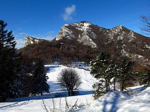
Monte Carone m. 1621
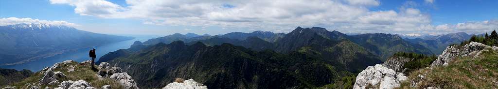
Monte Carone m. 1621 is a massive rocky summit belonging to the Prealpi Bresciane and Gardesane and dominating the Garda Lake with exceptional views. It's the highest summit of the namesake subgroup. This mountain is really interesting for discovering the important and well preserved remains of the First World War, built by the Italian command, placed on the former border between the Kingdom of Italy and the Austro-Hungarian Empire. Another highlight are the breathtaking summit views towards East over the mountains surrounding the Lago di Garda, as Monte Baldo, and towards West over Adamello, Presanella and Brenta Dolomites.
Monte Carone area was transformed into a large military complex: the aim was to block the road to eventual Austrian sorties onto Garda Lake western area. The remnants of this Italian military citadel still rise on the summit.
The wide panorama that you can enjoy from the summit of Monte Carone makes easily understand the importance of the site: the summit of "Carone" was so highly strategic for the control of this area that in the most exposed points there were observing sites, as well as several pitches for anti-aircraft artillery.
There are various Normal routes to the summit, but what makes unique this summit is the opportunity to climb up along the path n. 105 called “Sentiero Agostino Tosi”, through a wide rock chimney-gully about 150 meters high, equipped with stairs carved into the rock by the Alpine troops, that allows to climb along the exposed itinerary without any technical difficulty.
Getting There
As mentioned in the previous chapter, there are several walking approachs to the mountain, the shorter one is from Passo Nota m. 1208 and Bocca dei Fortini, from where you can climb the peak across a round trip.
Road access to Passo Nota
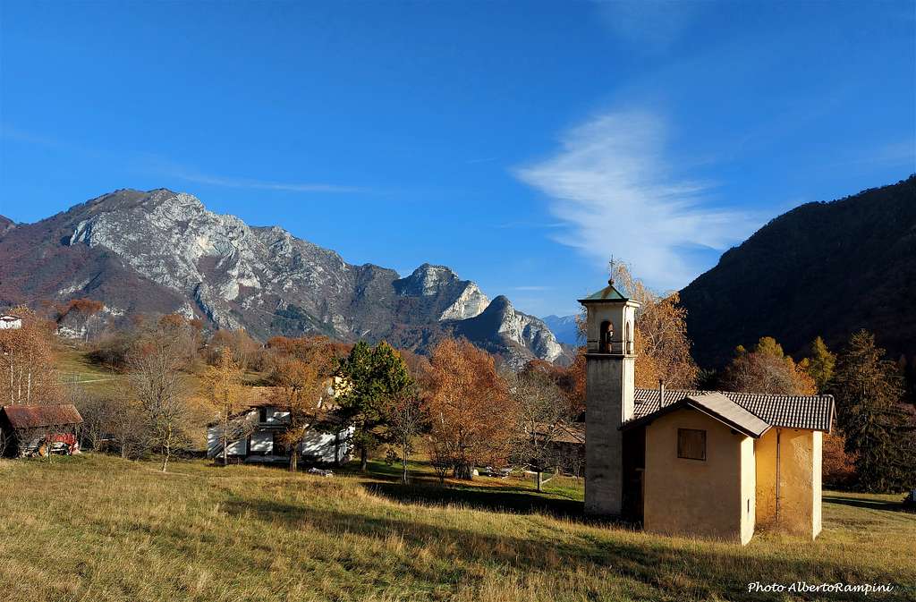
From Riva del Garda take the "Western Gardesana" to Limone sul Garda (10 km), where you turn right to Vesio and Tremosine. The road is very steep and immediately offers breathtaking views of Garda Lake; we are in the province of Brescia. After a few kilometers follow the signposts to Vesio and then take the good military road to "Passo Nota" m. 1200 (Bondo Valley). Parking lot. The pass is located 9 km from the village of Vesio.
Road access to Prè di Ledro
The second route follow a path rising from the village of Prè in Val di Ledro. From Riva del Garda follow the road to Val di Ledro, which is reached through two long tunnels. At the exit of the tunnel, continue along the main road, pass the village of Biacesa and shortly after turn left onto the road to Prè di Ledro 488 m. Park the car in the village.


Road access to Limone
The third route approach described in the following chapters starts directly by foot from Limone m 100 on Garda Lake Western shore, following the path n. 101 and involving a long hiking approach with a difference in level of about 1500 meters.
Route: Sentiero "Agostino Tosi" from Passo Nota
Sentiero "Agostino Tosi" from Passo Nota m. 1208
Summit quote: 1621 m
Difficulty: EE
Difference in level: 413 m from Passo Nota
Exposition: South
Time required: 3,30 hours round trip
Starting point: Passo Nota m 1208

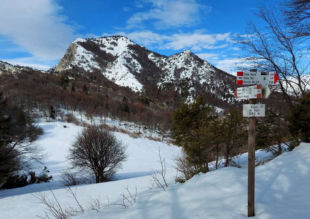
Park the car on Passo Nota m. 1208, just near the refuge "Passo Nota", open daily for most of the year. Paying attention to follow the signs to Baita Segala take the dirt road reaching soon a fork. Take the right branch that after a short ascent allows us to overcome Passo di Bestana. From Passo Bestana the path descends, getting soon a second fork. Turn again to right and follow the track, mainly on level, where it begins to appear in front of you the Southern side of Monte Carone. The track reachs Bocca dei Fortini, with several old military installation. Continue towards Baita Segala and Passo Guil for a few minutes, as far as you reach a panoramic clear with benches.


On the left near a charming cottage you will see the signpost to Cima Carone and "Agostino Tosi" path. Follow the path "Agostino Tosi" (path n. 105), reach a fork and take the right path (the left one climbs up the NW ridge of Carone) that leads, at first gradually rising inside the wood, then traversing on a well worn level track, to the bottom of the wide rocky chimney.


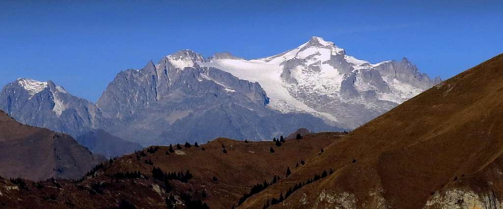
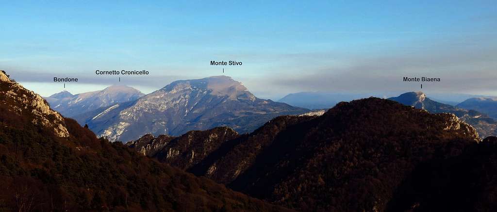
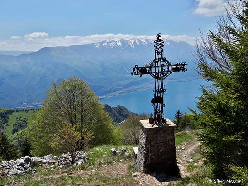
The route always climbs up well worn, following the rocky steps cut by the Alpine troops. Some fixed ropes help in the ascent, anyhow never difficult. Only a few steps are a little exposed, with outstanding views over the Garda Lake, but not difficult. As you are rising the chimney becomes narrower. The environment is really suggestive and fascinating. The route exits on the ending path, which after skirting the latest military fortifications, leads us to the summit, where it appears a beautiful view of Lago di Garda and Monte Baldo. On the opposite side you can enjoy a wide panorama towards Lago di Ledro, Adamello, Presanella and Brenta Groups. On the summit it was placed a big and featured iron cross carrying two WWI original helmets, an Italian one and an Austrian one, in memory of the First World War, fought on this peak.
Descent: you can reverse the route, but it's advisable to make a round trip, descending on the path n. 105 in the SE direction, getting a gravel road joining Passo Guil and Passo Nota. Following the road in the right direction reach the "Baita ANA Bonaventura Segala" and then Bocca dei Fortini and Passo Nota.
Route: Monte Carone from Prè di Ledro
Monte Carone from Prè di Ledro
Summit quote: 1621 m
Difficulty: E
Difference in level: 1130 m
Exposition: South-East
Time required: 5 hours round trip
Starting point: Prè di Ledro m 488
Along the SS 240 state road, between Riva del Garda and Molina di Ledro, it lies the small village of Prè di Ledro. Here it begins the path that crosses the old bridge over the Rio Ponale, starting point of the "Sentér de Malga Vil" (Path to Malga Vil). Parked the car in the small parking lot of the village, cross the bridge over the Ponale stream and take the steep concrete road, marked SAT n. 421, which with a beautiful walk in the wood leads to the locality Leano, a charming group of houses scattered on a wide meadow.
Just before the hamlet of Leano at a fork take the left branch - shorter and more direct - and continue on a mule track in the wood, then pass between two narrow rocky walls (called Bocche di Vil) getting to Malga Vil 1109 m.
Just beyond the shelter there is a second fork, here take the right branch ("Agostino Maroni" plaque). We enter a sparse wood where the path climbs with moderate slope reaching the ruins of a military village built during the First World War. From here we continue and soon we reach the top of Monte Carone.
Descent: you can reverse the route, but it's advisable to make a round trip. From the summit instead of taking the same route we take down the path 105 towards SE keeping the right. You lose altitude until you reach the wide gravel road joining Passo di Nota with Passo Rocchetta (Sentiero Antoniolli) and passing through the Baita ANA "Bonaventura Segalla". Following the road to the right we make a brief level digression to the Baita "Bonaventura Segalla", following it to the left we cross to the Passo di Guil where we leave the gravel track to turn left on the path 421. We pass through the beautiful grassland of Prati di Guil, then we begin to gradually lose altitude in the Valley of S. Antonio, reaching downhill the junction with the "Agostino Maroni" path where the ring is closed.
Route: Monte Carone from Limone del Garda
Monte Carone from Limone del Garda
Summit quote: 1621 m
Difficulty: E
Difference in level: 1500 m from Limone
Exposition: South-East
Time required: 8 hours round trip
Starting point: Limone del Garda m 100


In Limone (about 100 meters above sea level), take the path 101, cross a bridge over the stream S. Giovanni near "La Milanese" and continue on the path 101 on steep trail in the spectacular valley Singol. At a fork, turn to right to Passo Guil, Baita Segala and Cima Mughera (again on path n. 101). At a second fork below Cima Mughera turn to left, getting to Passo Guil 1209 m. Follow to the left the path 421 skirting Punta Mois and reach the start of the path to Monte Carone before getting to Baita Segala. Turn to right following the path rising with some hairpins inside the wood, then on meadows to the summit.
Descent: reversing the same route
Red Tape
No permits, no fees required
Hiking and scrambling scale
T - Turistico (Tourist): Itineraries on wide, clear and well worn paths, sometimes on mule tracks or gravel roads. The routes are never exposed, don't give any orientation problems and don't exceed 2500 meters of altitude. Suitable also for children
E - Escursionisti (Hikers): Itineraries on marked trails, even narrow and with possible steep and impervious sections. They are never exposed and don't give any orientation problems. They can tread different kinds of ground, such as forests, gravel, meadows, pastures, easy rocks, etc.). They form the majority of the trails that wind up in the mountains and require a certain habit to walk; you need equipment suitable for the altitude and resistant footwear with soles suitable for rough terrain
EE - Escursionisti Esperti (Experienced Hikers): Itineraries for hikers with experience and good knowledge of the mountain. Some of these paths may have exposed sections, however brief, which require firm foot and no dizziness. They require the ability to adapt to particular terrain, such as steep grassy slopes or stretches of rocks with difficulties that can reach the 1st degree of the UIAA scale. They can also reach high altitudes (3000 m or more). Sometimes they may include unmarked sections, requiring a good sense of orientation. Snow slopes are possible, however which can be overcome without specific mountaineering gear (rope, harness, crampons, ice-axe)
EEA - Escursionisti Esperti con Attrezzatura (Experienced Hikers with equipment - The same as EE, in addition these routes require the use of via ferrata equipment (lanyards, harness, carabiners, heat sink, helmet). This kind of itineraries range from the trails with short easy and not much exposed sections, previously equipped with fixed ropes and iron pegs, to the true and more difficult Via Ferratas climbing on rocky walls or on aerial ridges and ledges, previously equipped with long stretches of iron ropes, iron steps, ladders without which proceeding would constitute a real climbing. It is necessary to know how to use the technical equipment and have a certain habit of exposure and mountaineering terrains.
When to Climb
All year round. Be aware that in wintertime - in presence of snow and ice - the path "Agostino Tosi" may become more difficult and may require the use of crampons and axe.
Shelters along the route


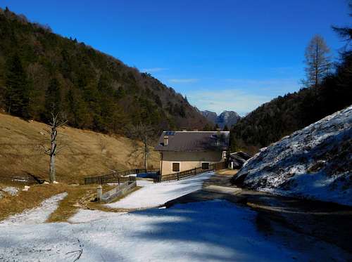
- Rifugio Alpini "Passo Nota" m 1208
- Baita A.N.A. "Bonaventura Segala" m. 1250
Accomodation
Several possibilities of accomodation in Limone del Garda, Tremosine and Riva del Garda.
Bibliography

"Prealpi Bresciane" - Fausto Camerini, Collana Gudie dei Monti d'Italia C.A.I.-T.C.I.
Maps
Kompass sheet 071 – Alpi di Ledro Valli Giudicarie 1:50.000 Lagiralpina sheet 016 - Alpi di Ledro - Tremalzo 1:25.000
Meteo Forecast
- Meteo Arpa Lombardia
- Meteo Alto Garda e Ledro
External Links
Sentiero Nota-Carone Museo della Guerra - Trentino