
-
 6306 Hits
-
 85.36% Score
-
 20 Votes
|
|
Mountain/Rock |
|---|---|
|
|
45.80696°N / 10.62723°E |
|
|
Trentino, Lombardy |
|
|
Hiking, Mountaineering |
|
|
Spring, Summer, Fall, Winter |
|
|
6398 ft / 1950 m |
|
|
Overview
Cima Tombea 1950 m
Cima Tombea is a mountain located on the border between Trentino and the province of Brescia in Lombardy. It's situated within the Parco Regionale dell'Alto Garda Bresciano and belongs to the Prealpi Bresciane and Gardesane. It's a massive mountain overlooking the beautiful Valvestino, situated near Lago d'Idro and Lago di Garda, with a long, undulating ridge running between the Bocca di Cablone and Passo Tombea. Cima Tombea shows a gentle grassy slope towards the South, while to the North it presents a steep and rocky slope with pinnacles, gorges and caves. Cima Tombea - besides being a high value hiking destination - is entered in the annals of world botany because of it constitutes the "classic habitat" of a rare endemic species that took the name of the mountain: the Saxifrage of Tombea. More than enjoying a great variety of flowers and interesting geological formations, from Cima Tombea - meaning "the summit of the graves" - you can enjoy a vast panorama: the view extends all over the Adamello to the Presanella, the Brenta Dolomites, the mountains of Trentino to the Dolomites of Val di Fassa, Garda Lake and the Apennines, as fully shown by the fine panel orientation which sits atop.
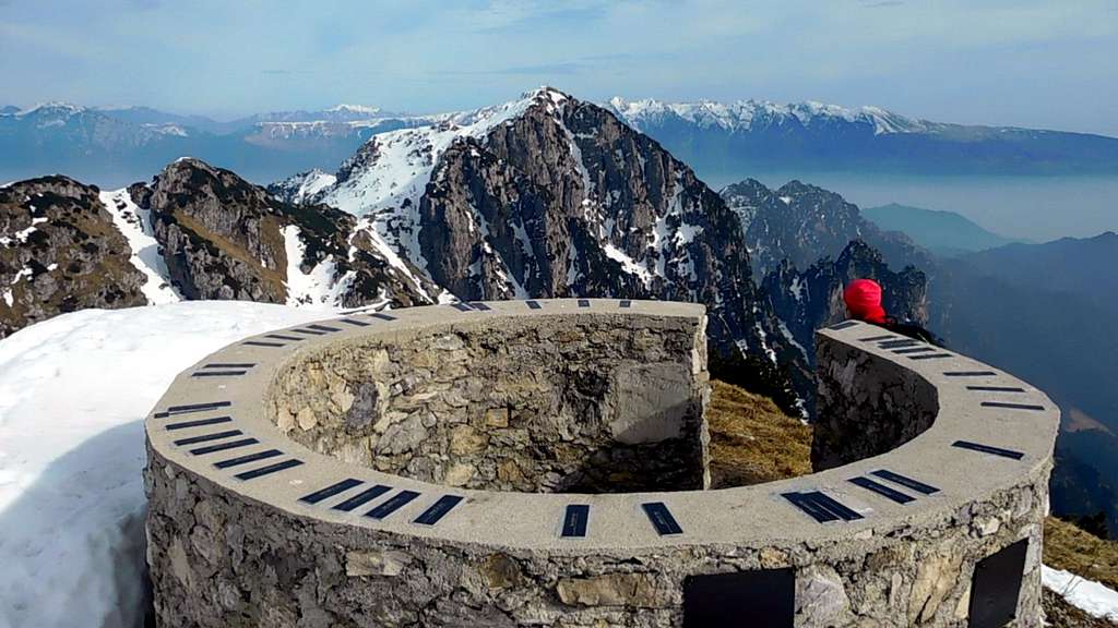
Cima Tombea è una montagna situata al confine tra il Trentino e la provincia di Brescia in Lombardia. Si trova all'interno del Parco Regionale dell'Alto Garda Bresciano e appartiene alle Prealpi Bresciane e Gardesane. È una montagna imponente che si affaccia sulla splendida Valvestino, situata vicino al Lago d'Idro e al Lago di Garda, con un lungo crinale ondulato che corre tra la Bocca di Cablone e il Passo Tombea. Cima Tombea è costituita verso Sud da inclinati pendii erbosi, mentre a nord presenta una ripida parete rocciosa con pinnacoli, gole e grotte. Cima Tombea - oltre ad essere un'interessante destinazione escursionistica - è entrata negli annali della botanica internazionale perché costituisce l'habitat classico di una rara specie endemica che prende il nome della montagna stessa: la sassifraga di Tombea. Oltre a presentare una grande varietà di fiori e interessanti formazioni geologiche, Cima Tombea - che significa "la cima delle tombe" - offre un vasto panorama: la vista spazia sull'Adamello fino alla Presanella, sulle Dolomiti di Brenta, le montagne del Trentino meridionale, le Dolomiti di Fassa, il Lago di Garda e perfino gli Appennini, come illustrato dalla bella tavola di orientamento che si trova in cima.
Getting There
There are two main routes to summit Cima Tombea, one starts from Cima Rest (Valvestino) and the other one starts from Alpo, near Ponte Caffaro, at the northern end of Lake Idro.
Road access to Cima Rest


- From Western Garda shore: from A4 Milano-Venezia Motorway exit Brescia West. Continue eastward along the South Ring Road-SS11 and then on SS45-West Gardesana. Leave to the right the detour to Salo, and continue along the Western shore of Garda Lake, pass Gardone Riviera, Maderno, Toscolano, Bogliaco and Villa. Shortly after Gargnano,leave the Western Gardesana road and take the road to Valvestino (signposts Magasa), rising up and getting a dam after several bends. on the right crossing the detours to Musaga, then the next Sasso, Liano, Formaga, Costa. A latter 'junction turn left, always along the SP9, it exceeds Navazzo and proceed towards the Valvestino. After the dam it runs on the right shore of the long and very narrow artificial lake of Valvestino and always keeping the right at the crossroads to Bollone and Capovalle Turano finally reaching Magasa 970 m. Shortly before entering the village on the right it departs an impressive winding road to reach the small village of Cima Rest 1200 m. Parking lot near the Church of the Alpini.
Road access to Alpo
Follow the SS 237 Caffaro towards Madonna di Campiglio, arrived in Ponte Caffaro, turn right just after the bridge and reach Baitoni. Continue on the road with several bends that rises to Bondone (8 km from Ponte Caffaro), then to the locality Alpo, where we leave the car.
Route: Cima Tombea from Cima Rest
Cima Tombea from Cima Rest
Summit quote: 1950 m
Difficulty: EE, F in wintertime
Difference in level: 750 m from Cima Rest
Exposition: South
Time required: 3 hours round trip
Starting point: Cima Rest 1200 m

The summit views are wide and spectacular. The whole area has a great botanical value due to the presence of rare endemic flora, such as "Saxifraga Tombeanensis". Also visible are the various military structures, built during the First World War, used as machine-gun and artillery pieces.
Route report - From the car park near the Church of the Alpini take to the left a narrow concrete road that rises to a few small groups of dwellings. The steep narrow street quickly rises to a collar with a few houses, where it falls in the midst of huge beech trees, getting Malga Alvezza 1280 m.


After the hut the concrete road restarts to rise, quickly reaching a crossroad. To the right it branchs the road to Val Campei, to the left it branchs the path to Bocca di Cablone; our path is the central one (n. 66, signpost "Caplone" and "Tombea"). The path enters the "Selva dal Ponte", a beautiful sparse forest of beech and fir with spectacular flowering, especially in the months of March and April, due to the presence of numerous examples of the Helleborus Niger and runs within the wood with several turns, amongst broad views of Magasa and the plain of Denai. After passing a little stream, the path reaches the highest and more sparse part of the wood, finally exiting into the open ground and rising up to a grassy shelf from where it appears the majestic and rocky southern slope of Monte Caplone and of the left the smaller Monte Tombea.Soon the path joins the fine and characteristic military track (n. 69) coming from the nearby Malga Tombea and connecting Bocca Cablone to the left and Bocca Campei to the right. Once joining the military trail (signposts) you must turn to left in the direction of Malga Tombea and Bocca Cablone. After 10 minutes you arrive near Malga Tombea, where on the right it starts a short path with several hairpins getting the summit of Cima Tombea.
Route: Cima Tombea from Bivacco Alpo
Summit quote: 1950 m
Difficulty: EE, F in wintertime
Difference in level: 450 m from Bivacco Alpo
Time required: 2,30 hours round trip
Starting point: Bivacco Alpo 1500 m

From the locality Alpo 1500 m follow the paved road that wanders from West the "Dos da fa"; after a signpost with the traffic ban it starts the dirt road (trail N. 444) that climbs up to the pass Bocca di Cablone 1775 m. From here you can turn to left and follow the obvious military road marking the old border during the Austro Hungarian Empire. On the road, in good condition, there are the various military ambushes carved into the rock. Through the war tunnels it reachs Malga Tombea, near which a signpost indicates the left path to reach the summit of Cima Tombea. From here the final part of the route is common with the previous itinerary from Cima Rest.


As an alternative to the military road, from Bocca di Cablone you can climb the ridge named Cresta del Gai and proceed along the ridge between dwarf pines and old paths. Almost from every point of the ridge you can go down the military road.
Red Tape
There are not special restrictions in climbing, hiking and mountaineering. Getting to Cima Rest be aware that cars are not allowed on the concrete road after Chiesetta degli Alpini.
Nature and flora

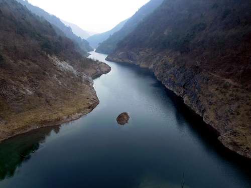
The Valvestino, a silent valley traveled by the picturesque and winding road rising from Gargnano, on Western Garda shore, offers panoramic views where the beauty of nature is absolutely addictive. The artificial Lake Valvestino formed by the a great dam built in 1962 appears like a fjord which is wedged in the mountains. The area is entirely included within the Parco Regionale dell'Alto Garda Bresciano. The vegetation gradually changes from oleander and olives to the oak woods and orniello up to beech, maple trees and pines to finally reach the high pastures. Having a great environmental importance for the presence of endemic flora subject of studies since 1700, Valvestino is also rich in history. Inhabited since prehistoric times, place of transit for the Romans and land border during the rule of the Austro-Hungarians, Valvestino became Italian in 1915. In the area interesting and old military remains can be seen walking on scenic and well-marked trails.


When to Climb
The ascent can be performed all year round. Winter ascents require the proper equipment (crampons and axe), as well as early spring ascents.
Accomodation
Several possibilities of accomodation along Western Gardesana and Lago di Idro.
Meteo
Meteo Arpa Lombardia
Meteo Trentino
Guidebooks and maps

Guidebooks

"Prealpi Bresciane" by Fausto Camerini - Collana Guide dei Monti d'Italia, CAI-TCI
Maps

Lagiralpina sheet 016 - Alpi di Ledro - Tremalzo 1:25.000
Kompass 102 - Lago di Garda e Monte Baldo - 1:50000