
|
|
Mountain/Rock |
|---|---|
|
|
39.45440°N / 106.1975°W |
|
|
13205 ft / 4025 m |
|
|
Attention winter climbers -Update January 25th, 2007
The followng message posted by GahugafugaCopper Mountain is permitted by the forest service to
operate on the entire east and north faces of Jacque Peak, plus the south
face of Tucker Mountain. They do nothing to advertise this fact (trail maps
don't indicate that these are the true boundaries) but they claim to have
the right to regulate how people pass through these areas during the winter
season. They allow the peak to be climbed via Tucker Gulch, Geller Gulch or
through the Janet's Cabin backcountry gate inside the resort, but descent
must occur only through these routes. Their posted boundary ropes are not
to be crossed in any circumstance, even if safe routefinding dictates it.
This is contrary to most ski resorts that enforce rope-ducking into the
backcountry but don't enforce boundaries when returning into the resort.
I'm not a lawyer so I don't know whether this is a proper policy,
considering the whole place is public land. I do know that I was almost
arrested for crossing a boundary and would've had the chance to test it in
the courts had it not been for an understanding ski patrol supervisor.
Jacque Peak Overview

In January of 2004, I participated in the first SP winter gathering at Breckenridge Colorado. A day prior to our planned ascent of Quandary Peak, Nelson and I hiked up a little known sub-summit of Pacific Peak called Mayflower Hill (12,600-ft.) The main objective that day was to admire the excellent easterly view of the Fletcher Massif. On the summit, we admired the dancing skyline of centennial thirteeners showing off a beautiful, and continuous symmetry. In addition to this memorable view to the east, the view west from Mayflower Hill conveyed prominence, in the form of a perfect triangular shaped mountain called Jacque Peak (13,205-ft.)
Located 1.6 miles southwest of Union Mountain in the Southern Gore Range, Jacque Peak provides the impressive backdrop to Copper Mountain Ski Resort. Because of Jacque Peak’s close proximity to the Tenmile Range, it’s an easy debate as to what mountain range Jacque Peak actually resides. Looking at a topo map it becomes clear; there is a Gore Range proper (Powell, Eagles Nest etc.) and there is a much smaller Southern Gore Range (Shrine Mountain, Jacque Peak etc.), which are separated by I-70 and Gore Creek. The swift Tenmile Creek is the obvious divider that separates the immense Tenmile Range (Crystal, Pacific Fletcher, Quandary Peak etc…) from the south Gores.
Jacque Peak’s standard summer routes are easy class 2 hiking. Both the northwest and the northeast ridge will escort you to the summit with minimal effort other than hiking the mileage and 3,000+ vertical feet.
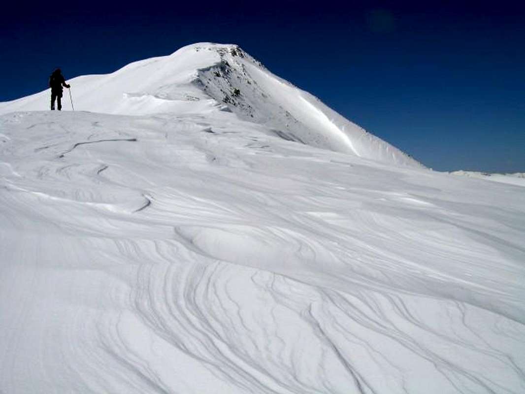
For those that who want more than a hike, Jacque Peak’s redeeming quality would be its safe winter routes and ski touring. During fall and winter when mother nature dumps a deep snow pack on Jacque Peak, both ridges become more inspiring and provide for a worthwhile outing. Thus I recommend this mountain in April or May, with a very early 5:00 or 6:00 a.m. start. The northwest ridge is almost always completely windswept and the northeast ridge holds more snow but is also considered safe. Keep an eye out for a cornice overhang on the northeast ridge. For those that like to backcountry ski, Union Mountain, Tucker Mountain and Jacque Peak have wide-open bowls to the south and the spring skiing must be heavenly as well as safe.
I have to admit that Jacque Peak has very good views as well. How can you go wrong with a complete view of the entire Gore Range, Tenmile Range, Northern Sawatch (Holy Cross Wilderness) and middle Sawatch (Elbert, Massive….) and lastly, the high fourteeners in the Maroon Bells Wilderness.
Accessing Jacque Peak is also easy; paved roads lead to three different starting points, like Copper Gulch, Tucker Gulch (hwy 91) and Geller Gulch (I-70).
 |  |
Getting There
This unsigned trailhead is on Colorado Hwy 91 and is easily approached from I-70 at Copper Mountain Ski Resort.From the junction of Interstate 70 and 91 head south 4.2 miles to a pull-off on the right side of the road right before the highway begins an obvious ascent to Freemont Pass. This pull off is the beginning of a feeder road that allows access to the private property for the huge tailings pond just south. Park at the fence, and begin your hike here.
Red Tape
(per Aaron Johnson)This is an unprotected area. There are no permits required, and no use, summit or parking fees. Colorado Highway 9 is open all year round. If you still have questions, contact the Clear Creek Ranger District of Arapaho National Forest:
Clear Creek Ranger District
101 Chicago Creek
P.O. Box 3307
Idaho Springs, CO 80452
(970) 567-2901
Mountain Conditions/Regional Weather
Click image to enlarge
Click here to view a 7-day forecast for Copper Mountain, Colorado
