
|
|
Mountain/Rock |
|---|---|
|
|
39.61650°N / 112.2196°W |
|
|
Juab |
|
|
Hiking |
|
|
Spring, Summer, Fall, Winter |
|
|
7504 ft / 2287 m |
|
|
 Fool Creek Peak in the distance
Overview
This peak is generally not noticed by most folks as they speed down US6 towards Delta or highway 122 towards Nephi and I-15. It is however, another interesting little peak that is worth a bit of a detour to visit as it is the highpoint of the Gilson Mountain range and a Utah prominence peak, coming in at a rather lowly #67 with 2254 feet of prominence. If you are not familiar with prominence, I'll explain this concept in a later section.
This is desert country and the flora on the mountain bears witness to this
fact. It is also BLM country, managed by that giant federal agency that manages a lot of the land in the state of utah. Cattle range on the lower
northern part of the range and deer and proghorn antelope manage to eek out a living as well. A few springs dot the range but overall, not one person I have asked since I've been in utah has ever heard of Champlin Peak or the Gilson mountain range. Many have heard of its nearest neighbor, Fool Creek Peak that is just east of Oak City, but again, none had heard of this one. Not even members of the hiking / climbing community. I hope this page will change that just a bit and for you prominence peak chasers, this is one that you can combine with a trip to Fool Creek Peak.
In the register atop the peak, I did find four people who are into chasing prominence peaks:
John Vitz from Manhattan Beach California
Gordon MacLeod from Simi Valley California
Barbara Lilley from Simi Valley California
Greg from Summitpost
The remainder of signees of the register were mainly hunters and BLM people with a few locals for good measure.
Getting There
 Area map - click twice
 Mt. Nebo in the distance
The easiest way is to come from I-15 via Nephi Utah. Nephi is a bit over an hour drive from Salt Lake City (I said a bit over) and less than an hour from Provo Utah. Turn off into Nephi and go through town on highway 132 which heads for Delta. At the 14 mile mark, as you drop over Furner Pass, watch for a paved road (road 148) that is signed for Little Sahara. Go three miles to a ranch road that leaves the pavement and heads southwest. In about a mile, you will come to a gate, opening and closing it after you. Another mile and a third brings you to a second gate and as before, be sure to open and close it after you. Continue on to a junction (1.1 miles) and turn south onto the road that heads up toward Champlin Peak. It was about 4 miles up the road to where I parked but if you don't have high clearance, you may need to park about the three to three and a half mile mark. There are two gates on the last bit of road and both may need to be open and closed, depending on how you find them. It was 7.45 miles from the highway (148) to where I parked.
Route
From where I parked, it was less than a mile to the summit with 1100 feet of elevation gain. Two ridges vie for your attention, one on the left side (east) and one on the right (west). I suggest the ridge to the west, I found it a good way to go and provided a straight forward but upward stroll to the summit. The route is so obvious that it does not need a detailed discussion here.Round trip: 2 miles
Elevation gain: 1100 feet.
This may vary depending on where you have to park your vehicle but even if you have to park a mile down the road, it is still an easy hike and perhaps
even more worthy of being listed here as a hike. This should be open for hiking most of the year, just remember to close those gates. We need to keep our ranching friends happy.
 Route map
Ken Jones posted his GPS track on peakbagger after his 2013 visit. See it HERE.
Peakbagger also indicates that 15 (as of Sept 2015) have been to the top of this one and another good resource is lists of john register that shows 19 ascents as of Sept 2015.
Red Tape
 the flora
Fillmore Field Office
35 E. 500 N.
Fillmore, UT 84631
Telephone: 435-743-3100
Fax: 435-743-3135
Camping
 The top
The BLM allows camping on their land (generally) although it is important that you practice the "leave no trace" type of camping. Clean up after yourself and leave no garbage. There is no firewood on this mountain so camp stoves are the way to go. Bring your own water, there is none available.
Prominence
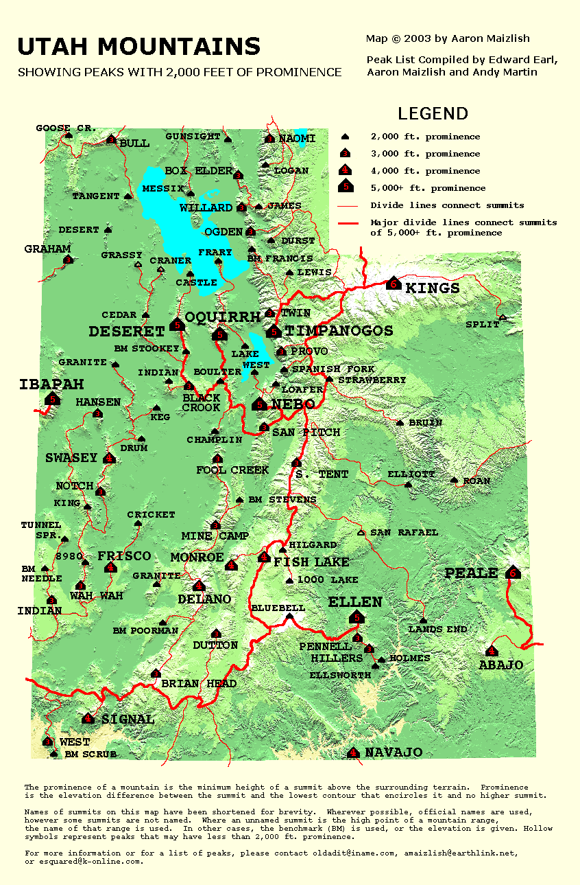
Utah has 84 prominence peaks with 2000 feet of prominence (or close to 2000 ft). Of course, many of them are in the western desert and provide a challenge of just getting to them.For a good explanation of prominence, check HERE. at peaklist.org.
Here's a great map you can see by clicking on this LINK.
Weather
Oak City Utah is the closest town of any consequence so Oak City weather would give a good idea of what the mountain would be experiencing
Links and the end
 close them puppies
Nearby attractions:
Little Sahara
List of John page: Link