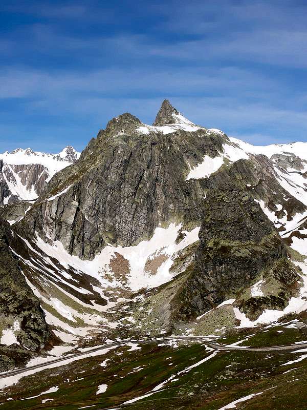
Fine mountain looking like a big pyramid, placed on the big ridge East-southeast of Mont Fourchon (2.902m), well visible driving to the Col of Gran San Bernardo. It deals with a secondary appendix that detaches him from the crest of border between Italy and Switzerland and that it divides the Italian "Vallone" of Fenetre above the Mountain Baou or Baous Pasture (2.356m) to North from the Basin above the Alp of Praz de Farcoz or of Prà di Farco (2.223m) to Midday; going down from the Fourchon the crest watershed exposed around one first wide Saddle 2.850 meters about and a smaller second and hold 2.800/10 meters around, at the base of the Crest/Edge West-northwest of the Pain de Sucre. From this he takes to go down with "hectic pace" forming the Great Shoulder 2.737 meters, a following quota 2.606 meters and a grassy-rocky tower and of forms mostly rounded off, called Comba (2.661m); over the crest it mostly turns him to South, "cut" around to quota about 2.290 meters from the path of connection not numbered among the Alpage Praz de Farcoz and the Alp Fonteinte/La Cantine of Aoste (2.203m; +) on the National Road n° 26 for the Pass of the near Great Saint Bernard (2.469m). Just from this point, highly panoramic, they macaws gotten burdens exceptional glimpses on the small pyramid, here slender to form of little horn and hand to be resembled, with the two respect as well as the proportions, to the Horn of Zinal or Zinalrothorn (but 4.221 meters!); instead from South, on the same road and beginning from the Commune of Saint Rhémy en Bosses (1.621m), it appears what square dolomitic tower with his surly South Wall, in foreground. Its etymology is to mean "Bread of Sugar" and is verifiable for other peaks of the Alps; instead its quota or altitude must be corrects from 2.919 meters, after 2.912 meters to 2.900 meters, as in the most recent effected surveys from the Papers R.A.V.A. (Regional Paper of the Autonomous Region of the Valley of Aosta) and in The publishing Excursionist "Gran St. Bernard Ollomont" Map of the paths n° 5. Already from an empirical analysis to naked eye, in manifold ascensions, he was noticed that from the Peak of the Mont Fourchon the Pain de Sucre appeared lower, even if of few, for thys thing the Cartography "it makes justice" to the first one that owes the most elevated Peak of this small Subgroup to be considered; to “partial revenge", the Pain de Sucre surely introduces more slender, elegant and thrilling lines the imagination of the mountain climber. From its summit a wide panorama on Mont Blanc, Switzerland Alps and Monte Rosa and in detail towards all the Alps Pennine, that are unfolded on the axle of frontier Ovest/Est putting from this point particularly in light the two near glacial masses of the Velan and the Combins. To South instead the sight spaces far on the whole Graian Alps of the Southeast to the border with the Piedmont (Apostles with Gran San Pietro, Gran Paradiso and satellites) and Southwest with the Valley of the Isère, in France (Great Sassière and Rutor Groups).
Bella montagna a forma di grande piramide situata sul crestone ad Est-sudest del Mont Fourchon (2.902 m), ben visibile salendo al Colle del Gran San Bernardo. Trattasi d'un'appendice secondaria distaccantesi dalla cresta di confine tra Italia e Svizzera e divisoria il Vallone italiano di Fenetre sopra la Montagna Baou oppure Baous (2.356 m) a Settentrione dalla Conca sopra l'Alpeggio di Praz de Farcoz o di Prà di Farco (2.223 m) in Mezzogiorno; scendendo dal Fourchon la cresta spartiacque forma una prima larga Sella 2.850 metri circa ed una seconda più piccola nonché ristretta 2.800/10 metri circa, alla base della Cresta/Spigolo Ovest-nordovest del Pain de Sucre. Da questo prende a discendere vertiginosamente formando lo Spallone 2.737 metri, una successiva quota 2.606 metri ed un torrione erboso-roccioso e di forme maggiormente arrotondate, chiamato Comba (2.661 m); oltre la cresta si rivolge maggiormente a Meridione, "tagliata" a quota 2290 metri circa dal sentiero di collegamento non numerato tra l'Alpeggio Praz de Farcoz e l'Alpe Fonteinte/La Cantine d'Aoste (2.203 m; +) sulla Strada Statale n° 26 per il Colle del vicinio Gran San Bernardo (2.469 m). Proprio da questo punto, altamente panoramico, si ottengon dei colpi d'occhio eccezionali sulla piramidina, qui slanciata a forma di piccolo corno e tale da rassomigliare, con il dovuto rispetto nonché le proporzioni, al Corno di Zinal o Zinalrothorn; invece dal Sud, sulla medesima strada ed a partire dal Comune di Saint Rhémy en Bosses (1.621 m), appare qual squadrata torre dolomitica con la sua arcigna Parete Sud, frontalmente in vista. La sua etimologia sta a significare Pan di Zucchero ed é riscontrabile per altre vette delle Alpi; la sua quota invece deve essere rettificata da 2.919, poi 2.912 metri a 2.900 metri, come nelle più recenti rilevazioni effettute dalla Carte R.A.V.A. (Carta Regionale della Regione Autonoma della Valle d'Aosta) e in L'escursionista editore "Gran San Bernardo Ollomont" Carta dei sentieri n° 5. Sin già da un'analisi empirica ad occhio nudo, in molteplici ascensioni, s'era notato che dalla Vetta del Mont Fourchon il Pain de Sucre apparisse più basso, anche se di poco, per la qual cosa la Cartografia "rende giustizia" al primo che deve essere considerata la Vetta più elevata di questo piccolo Sottogruppo; a "parziale rivincita", il Pain de Sucre presenta sicuramente linee più slanciate, eleganti ed esaltanti la fantasia dell'alpinista. Dalla sua cima si gode un panorama grandioso che spazia tra il Monte Rosa il Monte Bianco e le Alpi Svizzere ed in dettaglio su tutte le Alpi Pennine, da questo punto dispiegantesi sull'asse di frontiera Ovest/Est mettendo particolarmente in luce le due vicine masse glaciali del Velan e dei Combins. A Meridione invece la vista spazia lontano sull'intere Alpi Graie del Sudest al confine con il Piemonte (Catena degli Apostoli con il Gran San Pietro, Gran Paradiso e satelliti) ed a Sudovest con la Valle dell'Isère in Francia (Gruppi della Grande Sassière e del Rutor).
E-SE Ridge and E-ES Edge (Integral): Ruggero Busa, Ilario Antonio Garzotto and Renato Quendoz, (Jun 18th, 1967).
S Arête: Osvaldo Cardellina, (Oct 01th, 1990).
S-SW Wall: Osvaldo Cardellina, Valentina Bal, Federica Cargnino, Laura and Luca Pasteur, (Jun 18th, 1996).
N-NW Edge: Osvaldo Cardellina, Gianfranco Vicentini, Antonio and Francesco Fioretti, (Aug 27th, 1998).
Little North Wall: Emilio Bertona and Osvaldo Cardellina, (Jun 01th, 2000), in ascent.
W-NW Edge (Integral from Saddle 2.800/10 around): Osvaldo Cardellina, lone (Oct 01th, 2000), in descent.
S Wall (Rocky Gully and Great Dihedral): Osvaldo Cardellina, lone (Nov 25th, 2007), in ascent.
Note: In the T.C.I.-C.A.I, Guidebook Alpi Pennine vol. I of Buscaini the first ascent of the East-southeast ridge, is given to Giovanni e Luciana Rossi July 18th, 1970 with a question mark : the first rope team on the route were Busa, Garzotto, Quendoz in June 1967.
Nota: La salita della Cresta-Spigolo E-SE nella Guida Alpi Pennine vol. I° viene data come prima ascensione integrale (?) sino alla vetta alla cordata Giovanni e Luciana Rossi il 18 luglio 1970. Il ? dell'autore, Gino Buscaini è opportuno, poichè la medesima era stata già salita tre anni prima dalla cordata Busa, Garzotto, Quendoz, nel Giugno del 1967.
Getting There
BY CAR:
From Torino, Milano, etc: Motorway A5. Exit Aosta Est.
From Switzerland: through the Grand St. Bernard Tunnel or the homonym pass.
From France: through Mont Blanc Tunnel or Petit St. Bernard Pass. It isn't necessary to enter in Motorway A5, you can drive through SS.26 Aosta direction.
BY PLANE:
Aeroporto "Corrado Gex" Saint Christophe (Aosta).
Road Itinerary & Approaches
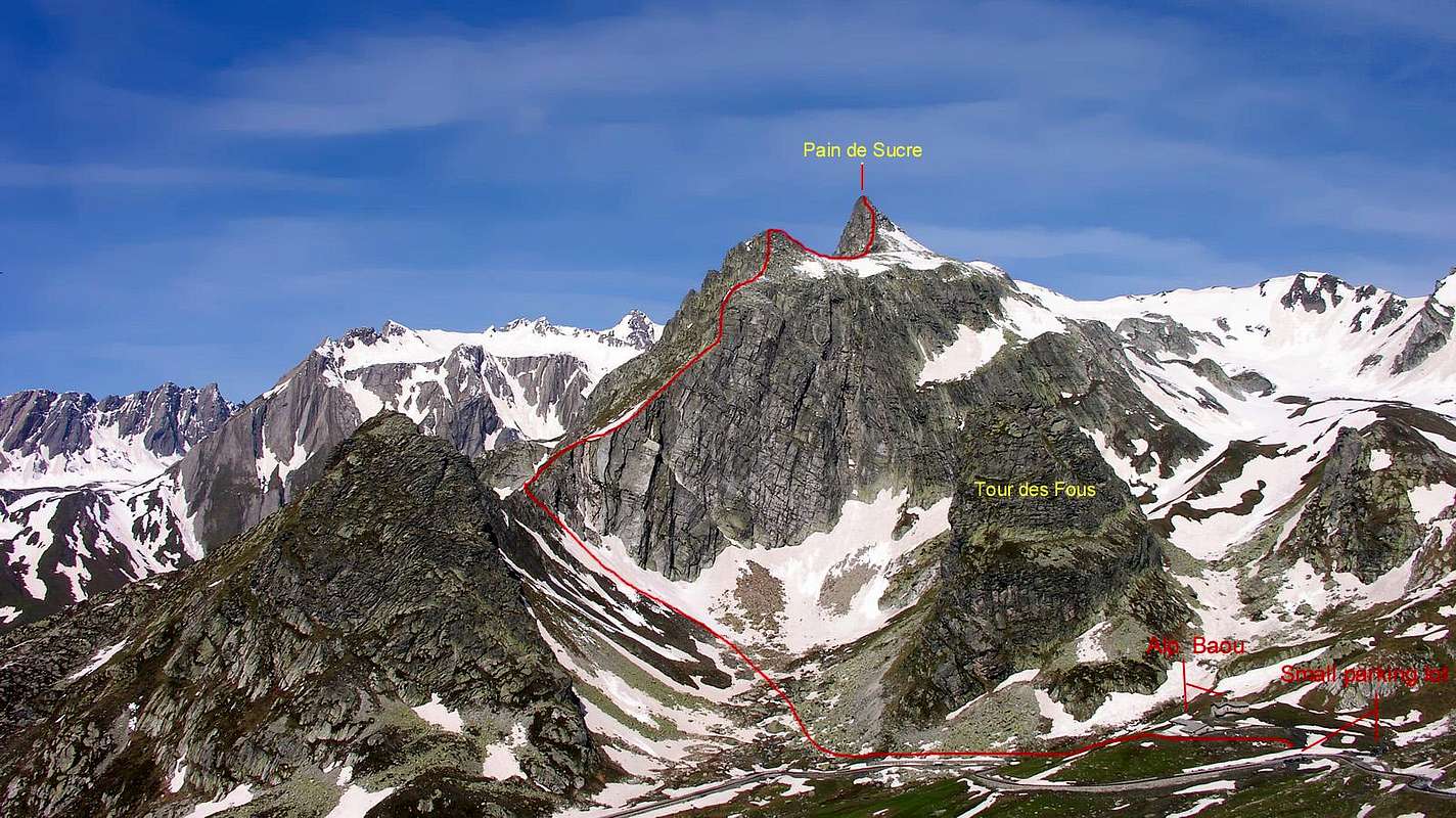
From Aosta drive along the Gran San Bernardo Road (SS.27) and, after Gignod, Etroubles and Saint Oyen you must leave to your left the road to the Tunnel driving toward Saint Rhémy en Bosses along the valley endin to the pass. After many hairpins and passing Pra di Arc Pastures (1.992m), and the Cantina Reggia Dogana (2.203m) you get a small car parking near the Alpe Baou (2.356m) wherefrom starts the route to Pain de Sucre. Instead for the run of the great Crest East-southeast not to reach the point first examined, on the contrary to stay himself first to the slopes of the Tour des Fous(2.579m), here spectacularly leaning; to begin from to lower houses parking lot in side earth of the road near to small stream that goes down in it "Combetta" (tiny basin) confined between the Tour and the Great Shoulder 2.737m of the Pain de Sucre. Through this mini walloon of great "clapeys" (= great blocks) square and small whitish rocks, alternate to meadow lines in steep progression, to address him to the overhanging Saddle 2.480 meters around from which he takes beginning the ascension of the real crest.
Dalla Città di Aosta (583 m) salire lungo la SS.27 del Gran San Bernardo e, dopo aver superato i Paesi di Gignod (988 m), Etroubles (1.264 m), e Saint Oyen (1.373 m), lasciare sulla sinistra la strada che porta al Tunnel del Gran San Bernardo. Salire verso Saint Rhémy en Bosses (1.632 m) continuando lungo il vallone che porta al Colle, dopo numerosi tornanti si supera l'Alpeggio di Pra di Arc (1.992 m), la Cantina Reggia Dogana (2.203 m), e, raggiunto un piccolo parcheggio nei pressi dell'Alpe Baou (2.356 m), si inizia la salita al Pain de Sucre per la Via Normale che si snoda attraverso il lungo e vasto Vallone di Fenetre. Invece per il percorso del Crestone Est-sudest non raggiungere il punto anzi esaminato, bensì fermarsi prima alle pendici della Tour des Fous(2.579 m), qui spettacolarmente pendente; iniziare da un minuscolo parcheggio in terra a lato della strada nei pressi di un torrentello che scende nella "Combetta" rinchiusa tra la Tour e lo Spallone 2.737 metri del Pain de Sucre. Tramite questo valloncello di grandi "clapeys" squadrati e piccole rocce biancastre, alternati a tratti prativi in ripida progressione, indirizzarsi alla soprastante Sella 2.480 m~, dalla quale prende inizio l'ascensione della cresta vera e propria.
The Normal Route
A) - Through the Fenetre Valley, Northern Slope and terminal part of West Edge: from the small dirt parking on SS.27 (Km 31,200 from Aosta Town) of Great Saint Bernard, winding road 2.356m, near Montagna Baou or Baous (2.356m, before and briefly by West direction, path n° 13A, to Fenetre's Torrent, in quota 2.390 meters around; after by Northwest way to cross, by typical white "escalier" (= stoneflight of steps). Go up on a small grassy valley to crossroads 2.515 meters about, near the same torrent and below the quota 2.557 meters. From this point, abandoning the "mother path" on the right that, again crossing the stream, it is addressed with direction North-northwest to the Hill Fenetre de Ferret (2.698m), to continue toward West and with a good small path not numbered but with various signalings, above the long grassy promontory that dominates of few the fund or floor of the walloon; it is reached so a vast and ample plateau, at times with rests of snowcapped, center of an ancient extracts of slate. To continue with the same direction on the fund of the "vallone" with the path, that becomes less beautiful but also always evident, up to reach, with a curve to arc and to quota 2.750 meters around, a splitting of the same one always addressed to the Mont Fourchon (2.902m); here the direction changes in South-southwest and is worthwhile to take the ramification of left climbing (East). Through soil, debris deposits and stony ground he reaches the wide Saddle 2.850 meters around as soon as to East of the aforesaid point, on the crest watershed with the "Vallon" of Praz de Farcoz; leaving on the right (West) the route for this mountain, to change completely direction and to easily cross the wide ridge in direction of the Pain de Sucre. This finishes in a small rocky prominence above a small and tightened saddle to quota 2.800/10 meters around; on a trace through the steep, but easy, rocks and with a North diagonal South to look for the best "via" to go down to this last (good point adapts for" salle à manger", above all to the return from the Peak). To climb the Western-northwestern Slope, below the Crest/Edge West-northwest, through obvious traces in North side by some greats rocks (I°/I°+). More in details, at first to double on the right with similar traces an emergent rocky islet from the whitish stony ground, broken appendix of the basal part of the small Edge North-northwest. Then to cross a band of minced routs of reddish color entering to a following with the same characteristics but of brownish color, at the end of which a brief crossing to the left conducts to a series of stacked blocks divided by small rocky channels with soil; to go up again among the same ones, looking for the most convenient passages (especially in presence of snow), going out on a little balcony on the Edge West-northwest, with to the right and in low a beautiful gendarme. To continue on the thread, with amusing gymnastics, on great blocks passing over a "gun" leaning followed from a small quadrated tower, leaving to the right the first one and the second in opposite sense; climbing a lower case "mauvais pas", always of a little to the right under the crest, shortly to achieve to aerial summit (2.900m; wooden cross; 1h'30/2h'00).
NOTE: through a small divergence toward West from the wide Saddle 2.850 meters around, it is possible shortly time to also climb the Mont Fourchon (2.902m) along the crest watershed and with a small deviation to the right (North) on the Slope East-southeast, easily in terminal part through white and rotten rocks with debris (0h'30/0h'45 round trip; EE/A; F); from these effecting in descent the inverse run he returns to the saddle completing then the crossing to the Pain de Sucre, in a beautiful classical traverse with good photographic possibilities.
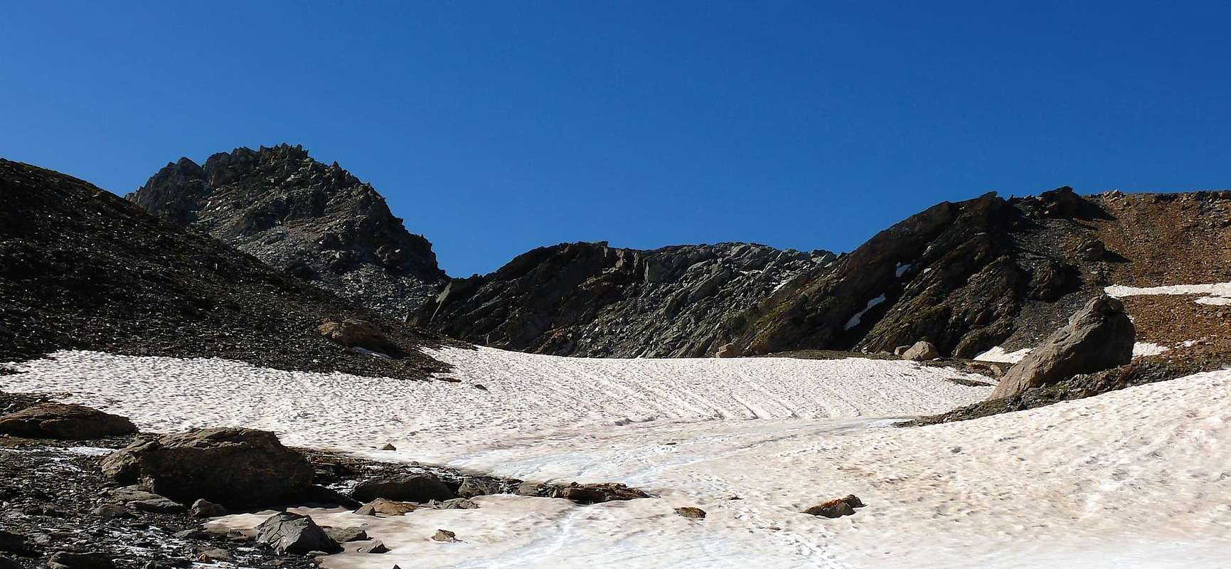
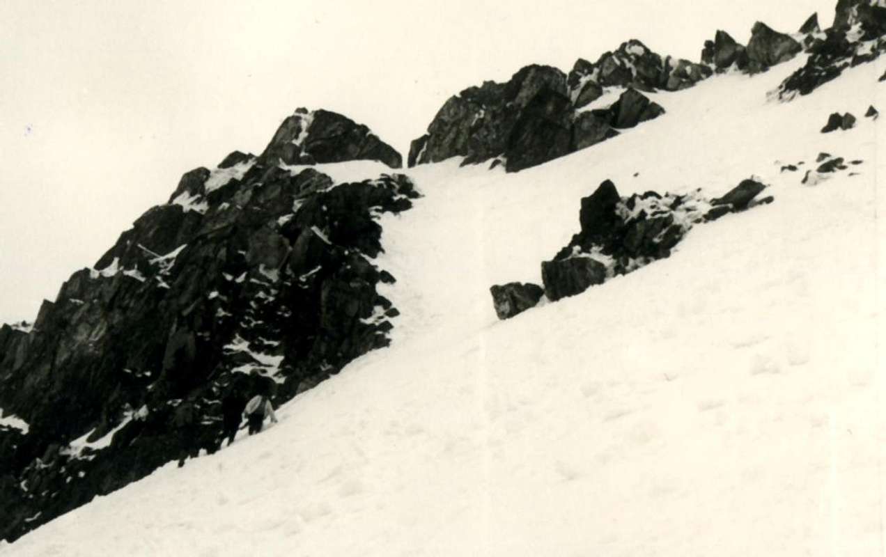
VARIANT: from the floor valley, as soon as after having over past a minuscule lake to quota 2.582 meters and just before to cross to quota 2.615/20 meters about a secondary deviation toward Northeast addressed Fenetre to the Pass de Ferret, to abandon the path for the Mont Fourchon and with South direction to go himself instead i pour a gully-throat, that begins to quota 2.675 meters around and that salt forming a mountain range-gorge among two benchs-slabs of broken rocks. To go up again it on soil and minced rocks and decayed by the waters of fusion (generally to beginning of season they are found snowcapped that, if they were in hard snow and frost, they ask for a certain attention and even also the use of the crampons). Alternatively, without forced run, it is possible to lean on himself on the left however (East) going up again oblique an ramp of broken rocks and great gravels under to tilted rocky "banconata"; to the top of the same one to reenter then on the right bringing himself in the superior slant (generally snowy; see under the second picture) and with these to basic the North-northwest of the Pain de Sucre. The slope don't continue toward South to reach the small Saddle 2.800/10 meters around, on the contrary to begin the slope toward left on great rocky and sharp blocks, called in the Valley of Aosta "clapeys" and of grey-reddish color, rejoining shortly himself to the traces of the preceding route near a half dozen of great boardings of rock a lot of white (generally snowcapped residue also in late summer). This results to be in reality the Normal Route for the mountain, even if we recommend the precedent itinerary, surely more panoramic and less fatiguing (to calculate 0h'15 in less).
In DESCENT: by same route, also from 2.800/10m~ Saddle to descent by debris couloir through the VARIANT to floor valley in altitude 2.600 meters around and by path to East to joint the Mountain Baùs (2.356m).
A) - Lungo il Vallone di Fenetre, il Versante Nord e poi Nord-Nordovest e la parte terminale dello Spigolo Nordovest: dal piccolo parcheggio in terra battuta sulla Strada Statale n°27 del Grande (al Km 31,200 metri circa da Aosta) al tornante 2.356 m, appena al di sopra della Montagna Baou oppure Baous (2.356 m, dapprima e brevemente con direzione Ovest e tramite il sentiero n°13A, portarsi verso il Torrent Fenetre, a quota 2.390 m~; dopodiche, salendo più a Nordovest, risalire lungo un tipico e biancastro "escalier" (= scalinata semi-rocciosa). Risalire il soprastante valloncello erboso insino all'incrocio dei sentieri a quota 2.515 metri all'incirca, nei pressi del torrente medesimo e sottostantemente alla quota 2.557 metri. Da questo punto, abbandonando il "sentiero madre" sulla destra che, riattraversando nuovamente il torrente, si indirizza con direzione Nord-nordovest al Col Fenetre de Ferret (2.698 m), proseguire verso Occidente e con un buon sentierino non numerato ma con segnalazioni varie, sopra il lungo promontorio erboso dominante di poco il fondo del vallone; si raggiunge così un vasto ed ampio plateau, a volte con resti di nevati, sede di un'antica cava di ardesia. Proseguire, stessa direzione, sul fondo del vallone con il sentiero, che diventa meno bello ma pur sempre evidente, sino a raggiungere, con una curva ad arco ed a quota 2.750 metri circa, uno sdoppiamento del medesimo sempre indirizzato al Mont Fourchon (2.902 m); qui la direzione cambia in Sud-sudovest e conviene prendere la diramazione di sinistra salendo (Est). Tramite terriccio, depositi detritici e pietraie si arriva alla larga Sella 2.850 metri circa appena ad Oriente della predetta punta, sulla cresta spartiacque con il Vallone di Praz de Farcoz; scartando sulla destra la via per questa montagna, cambiare completamente direzione e percorrere facilmente il largo crinale in direzione del Pain de Sucre. Questo termina in un piccolo risalto roccioso sopra una stretta selletta a quota 2.800/10 m~; su d'una traccia attraverso le ripide, ma facili, rocce e con un diagonale da Sud a Nord cercare la via migliore per scendere a quest'ultima (ottimo punto adatto a "salle à manger", soprattutto al ritorno dalla Vetta). Risalire lungo il Versante Nord-nordovest sottostantemente la Cresta/Spigolo Ovest-nordovest su evidenti tracce a Nord e alcuni roccioni (I°/I°+). Più dettagliatamente, dapprima doppiare sulla destra con tracce similari un isolotto roccioso emergente dalla pietraia biancastra, appendice spezzata della parte basale dello Spigoletto Nord-nordovest. Indi attraversare una fascia di rotte trite di colore rossiccio accedendo ad una successiva con le stesse caratteristiche ma di colore brunastro, al termine della quale una breve traversata a sinistra conduce ad una serie di blocchi accatastati divisi da canalette con terriccio; risalire tra i medesimi, cercando i passaggi più convenienti (soprattutto in presenza di neve), uscendo su di un terrazzino dello Spigolo Ovest-nordovest, con a destra ed in basso un bel gendarme. Proseguire sul filo con divertente ginnastica su grandi blocchi, passando oltre un "cannone" pendente seguito da una piccola torre squadrata e scartando il primo a destra e la seconda in senso opposto; scalando un minuscolo "mauvais pas", sempre di poco a destra sottocresta, in breve raggiungerne l'aerea vetta (2.900 m; croce di legno; 1h'30/2h'00).
NOTA: tramite una piccola divergenza verso Occidente dalla larga Sella 2.850 m~, é possibile in breve tempo salire anche il Mont Fourchon (2.902 m) lungo la cresta spartiacque e con una piccola deviazione a destra (Nord) sul Versante Est-sudest, nel tratto finale attraverso rocce rotte e biancastre ricoperte da detrito nonché di facile percorrenza (0h'30/0h'45 in andata e ritorno; EE/A; F); da questi effettuando in discesa il percorso inverso si ritorna alla sella compiendo poi la salita al Pain de Sucre, in una bella traversata classica con ottime possibilità fotografiche.
VARIANTE: dal fondovalle, appena dopo aver oltrepassato un minuscolo laghetto a quota 2.582 metri e poco prima di incrociare a quota 2.615/20 m~ una deviazione secondaria verso Nordest indirizzata al Colle Fenetre de Ferret, abbandonare il sentiero per il Mont Fourchon e con direzione Sud portarsi invece verso un canalone-gola, iniziante a quota 2.675 m~ e che sale formando una giogaia tra due banconate di rocce rotte. Risalirlo su terriccio e rocce trite e marcite dalle acque di fusione (in genere ad inizio di stagione si riscontrano nevati che, qualora fossero in neve dura e gelata, richiedono una certa attenzione e magari anche l'utilizzo dei ramponi). Alternativamente, senza percorso obbligato, é comunque possibile appoggiarsi sulla sinistra (Est) risalendo una rampa obliqua di rocce spezzate e ghiaioni sotto una banconata rocciosa inclinata; al sommo della medesima rientrare poi sulla destra riportandosi nei pendii superiori (generalmente innevati; vedi sopra la seconda foto) e con questi alla base Nord-nordovest del Pain de Sucre. Non continuare la salita verso Sud per raggiungere la piccola Sella 2.800/10 m~, bensì iniziare la salita verso sinistra su grandi blocchi rocciosi e taglienti, detti in Valle d'Aosta "clapeys" e di colore grigio-rossastro, ricongiungendosi in breve alle tracce della via precedente nei pressi di una mezza dozzina di grandi tavolati di bianchissima roccia (in genere nevato residuo anche in tarda estate). Questa risulta essere in realtà la Via Normale per la montagna, anche se noi consigliamo il precedente itinerario, sicuramente più panoramico e meno faticoso (calcolare 0h'15 in meno).
In DISCESA: ripercorrere lo stesso itinerario, oppure dalla Sella 2800/10 metri circa scendere per un canalone detritico con la VARIANTE nel fondo del vallone fino a quota 2.600 metri circa e su sentiero verso Oriente raggiungere il parcheggio della Montagna Baùs (2.356 m).
E-SE Ridge the Smart & Finest Route
C) - From the car parking of Alpe Baou, after a short descent, climb to the left to a notch (2.480m), along big stones; follow the edge of the ridge (the rocks becomes better). After a Shoulder (2.737m)a short descent leads to the last steep summital tower: along the sharp edge to the summit (4h'00/4h'30).
C) - Dalla Strada Statale n°27 a quota 2.320 m sotto La Tour des Fous (oppure dal parcheggio nei pressi dell'Alpe Baou 2.356 m, dopo una breve discesa), innalzarsi sulla sinistra sino al Colletto (2.480 m), su blocchi; tenere il filo di cresta con la roccia che migliora salendo. Dopo lo Spallone (2.737 m) una breve discesa porta all'ultimo ripido torrione sommitale, che diventa uno spigolo alquanto affilato (4h'00/4h'30).
From the "Diario Alpinistico 1964-1969" (unpublished) of Ilario Antonio Garzotto (dead on Aiguille Croux - + 29/09/1969). "... we start at the foot of Tour des Fous (2.576m) at 7.30', there's still a lot of snow. The ridge is easy if you don't look for difficulties, we look at them. A Dülfer, a big slab with small grips, more Dülfer and more slabs and we are on the shoulder. After a short descent and a flat stretch we attach the last ramp. An iced chimney (it's june 18, 1967), a very steep slab and a very sharp and amusing edge are the last obstacles ..."
Dal "Diario Alpinistico 1964-1969" (inedito) di Ilario Antonio Garzotto († 29-09-1969 parete S-E Aiguille J.J.Croux, via Ottoz). "Partiamo ai piedi della Tour des Fous (2576 m.) alle ore 7.30' c'è ancora moltissima neve. La cresta è facile se non si cercano difficoltà: noi le cerchiamo. Una Dülfer, una grande placca dai piccoli appigli, altre Dülfer e altre placche e siamo sulla spalla della cresta. Dopo una breve discesa e un tratto piano attacchiamo l'ultima rampa. Un camino ghiacciato (è il 18 giugno 1967), una placca ripidissima e una crestina molto affilata che è divertentissimo superare sono gli ultimi ostacoli."
Difficulties
DESCRIBED ROUTES
A) - For the Standard Route or North-northwest Slope: easy or for EE/A; from F to F+; for the Variant: EE/A; F+ with brief passages of I°/I°+.
A) - Per la Normale o Versante Nord-nordovest: facile ovvero per EE/A; dal F al F+; per la Variante: EE/A; F+ con brevi passaggi di I°/I°+.
B) - For the East-southeast Ridge: not easy for AExpert (= Expert Mountaineers) AD+; passages up to the III+ (UIAA), with some exposure.
B) - Per il Crestone Est-sudest: non facile e consigliata ad Esperti; AD+, con passaggi dal II° al III+ (tratti esposti).
ALL OTHER ROUTES in EXISTENCE in clockwise order
C) - Directly through the small North Face: A; from PD to PD+; II°/II°+ and a small and short passage of III°-.
C) - Direttamente per la piccola Parete Nord: A; da PD a PD+; II°/II°+ ed un passaggino di III°-.
D) - For the South Wall: AExpert; from AD+ to D-, with passages of III°/III°+ and one pitch of IV°-; five pitons.
D) - Per la Parete Sud: AExpert; da AD+ a D-, con passaggi di III°/III°+ ed un tiro di corda di IV°-; cinque chiodi.
E) - For the Southern Ridge: A; AD-, with short passages of II°+/III°/III°-; on the thread one small part of III°+; two pitons.
E) - Per il Crestone Sud: A; AD-, con brevi passaggi di II°+/III°/III°-; sul filo un tratto di III°+; due chiodi.
F) - For the South-southwest Face: EE/A; II°/II°+ and a brief passage of III°-.
F) - Per la Faccia Sud-sudovest: EE/A; II°/II°+ ed un breve passaggio di III°-.
G) - For the Integral West Edge from the little Saddle 2.800/10 metri circa: EE/A; II°/II°+ and one brief passage of III°-.
G) - Per lo Spigolo Ovest Integrale dalla Selletta 2.800/10 metri circa: EE/A; II°/II°+ ed un breve passaggio di III°-.
H) - For the little North-northwest Edge: EE/A; PD-; I°/I°+/II° with a short stretch of II°+; one piton.
H) - Per lo Spigoletto Nord-nordovest: EE/A; PD-; I°/I°+/II° con un breve tratto di II°+; un chiodo.
Climbing Shots
Campings
Remember that free camping is forbidden (except for emergency reasons, over 2.500m, from darkness until dawn).
Gear
Mountaineering equipment: rope, pitons, carabiniers, helmet and some binds.
Corda, chiodi da roccia, moschettoni, casco e qualche fettuccia.
Mountain Conditions
You can get meteo information at the official site of the Regione Valle d'Aosta:
FONDAZIONE MONTAGNA SICURA Villa Cameron, località Villard de la Palud n° 1 Courmayeur (AO) Tel: 39 0165 897602 - Fax: 39 0165 897647.
SOCIETA' DELLE GUIDE DELLA VALPELLINE Etroubles-Strada Nazionale, n° 13 - Tel +39 0165 78559 - Valpelline-Loc Capoluogo, n° 1 - Tel +39 0165 713502 (AO) Italia.
A.I.NE.VA. (Associazione Interregionale Neve e Valanghe).
Useful numbers
Protezione Civile Valdostana località Aeroporto n° 7/A Saint Christophe (Ao) Tel. 0165-238222.
Bollettino Meteo (weather info) Tel. 0165-44113.
Unità Operativa di Soccorso Sanitario Tel. 118.
Acknowledgements
I am greatly indebted to my friend "Osva" for the detailed description of the routes and texts. In addition I want to thank Gabriele Roth & Osvaldo for the translation of the text from italian.
Parents refers to a larger category under which an object falls. For example, theAconcagua mountain page has the 'Aconcagua Group' and the 'Seven Summits' asparents and is a parent itself to many routes, photos, and Trip Reports.

 15226 Hits
 93.58% Score
 43 Votes