
|
|
Mountain/Rock |
|---|---|
|
|
39.42400°N / 119.6636°W |
|
|
Washoe |
|
|
Hiking, Scrambling |
|
|
Spring, Fall |
|
|
6305 ft / 1922 m |
|
|
Overview
Situated just east of Reno in the Virginia Range is Peak 6305. Locals call it Camel Back Peak based on its twin summits appearing similar to camel's humps. Camel Back Peak is made up of two rocky-topped buttes with spectacular features. The highlight of the hike is a steep-walled canyon at the beginning of the primary route. This is referred to by locals as Eagle Canyon. Camel Back Peak is located only one mile north of the loftier Louse Benchmark 6862'. Camel Back Peak is visible from the east in parts of the Reno skyline. It stands out in particular because it has two rocky bumps rising over 200 feet from their base. Camel Back Peak is the higher of the two buttes - located southeast of the lower butte which is about 6297'. Hiking Peak Camel Back Peak takes about 2 to 3 hours, particularly due to the long time it takes to get through the canyon. The canyon involves some easy class 3 climbing, and a lot of scrambling. There is only minor scrambling to the top of Camel Back Peak. The best time to hike Camel Back Peak is late fall and early spring. During summer months, rattlesnakes like to make a home in the canyon and elsewhere on the mountain. Winter creates ice in the canyon. It is recommended to hike here in the early afternoon because the sun shines brightly on the rocky features of the canyon and the peak during these hours, making views far more interesting.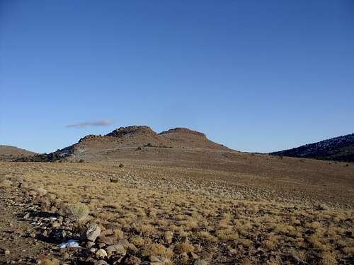 Looking back at Camel Back Peak
Getting There
Getting to Camel Back Peak hasbeen a challenge in recent years due to construction near the base of EagleCanyon. However, a new bypass trail was created to access theroute. Take 395 from Reno to exit 59 – Damonte Ranch Parkway. Once off thehighway, head east towards the mountains and turn left on Steamboat Parkway. Atthe end of Steamboat Parkway, take a right on Rio Wrangler Drive. The canyoncomes into view to the east. Take Yee Haw Way towards and continue onTrailrider Drive. Head up towards Tobiano Drive. Across from Tobiano Drive on Trailrider is apaved path. Take this paved path and cross over rocks to a trail on theother side. Alternatively, you can get to the trail without crossing therocks. Just take a right off Trailriderat Gold Mine. Take your first left onCavalry Circle and head up about 800 feet to the paved path.
Route Information
The canyon route is the most straight-forward way up, but not necessarily the quickest. There is a road that approaches from the north that is an easy walk. If taking the canyonroute, take the hikers path as it crosses the construction site, and continue untilit dies out and stay in an open area until you reach the foot of thecanyon. That is reached less than a mile. The canyon starts at about 4900 feet and climbs up to 5570 feet in about ¾ of a mile. However, this will take most hikers at least 40-45 minutes due to the difficult terrain. There is no trail, and there is lots of rock scrambling, including a few class 3 moves. Watch for falling rock, and ice during winter.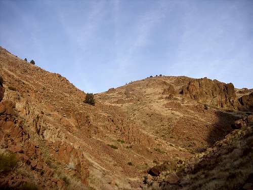 Entering the canyon
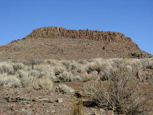 Heading to the final summit block
Red Tape
If parking near the paved path,there is no trailhead. It is in aneighborhood. Just be respectful andpark on the street. There are no issues or permits needed to hike up the canyonitself.
Once at the top of the canyon, it is not clear what is public land and what is private. There is a house located to the south of Louse Benchmark and there is a “No Trespassing” sign along the road between Louse Benchmark and Camel Back Peak to the south, but no fence to designate private land. Just be careful and watch for any signs that you might be on private land since it is not clearly marked.