
|
|
Mountain/Rock |
|---|---|
|
|
39.48493°N / 119.69106°W |
|
|
Storey |
|
|
Hiking |
|
|
Winter |
|
|
5768 ft / 1758 m |
|
|
Overview
Quite often illuminated as the sun sets in Reno, Nevada, the Virginia Range provides a quiet spot for hiking in the hills. Situated in Hidden Valley in the northern part of the Virginia Range, a series of "colored hills" rise above a public park. These hills reach an elevation of 5,768'. While not high by Nevada standards, they do rise over 1300' above the city. Point 5,768 itself only has a prominence of 140' from neighboring Road to Nowhere Mountain 6,075'. But these two summits are about 1.2 miles apart and there are a few ups and downs in between. Point 5,768 is a worthy destination on its own.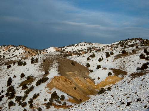
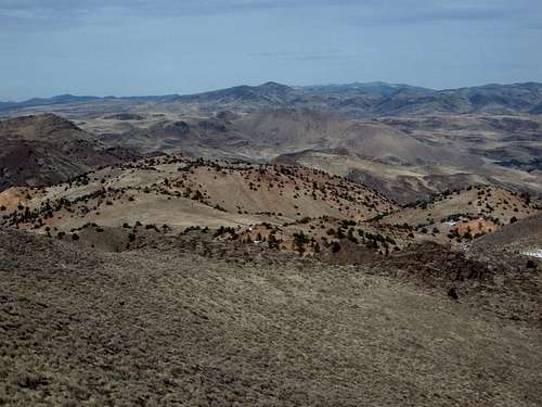
Zoom shot of the Colored Hills and 5768 from the trail up Peak 6075
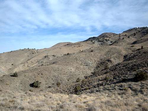
Access to the trails up to Point 5768 start in Hidden Valley County Park, just east of the city. Only 10-15 minutes drive from downtown Reno, Hidden Valley County Park offers good opportunities for running and trail hiking. Shadowed by higher summits to the north and south, these colored hills rise directly above the park. Point 5768 is the highest point in these hills. The 2nd highest is Point 5765 which appears to be the highest point when looking at the mountains from the city.
View along the trail up to Point 5768
Point 5768 sits across from Peak 5987 to the north and Peak 6075 to the south.
There are a few things to be aware of before hiking here.
1) The route to the summit is very steep. You hike over 1,000 feet in about 3/4 of a mile. In fact, it is so steep that at points on the trail, sheer gravity makes your pants start to fall down. No joke!
2) This mountain is best hiked starting in November and through February. During other parts of the year heat, snakes, and mud make hiking here unpleasant. Do not hike here after a rain storm.
3) This mountain is apparently the community bathroom for wild animals living in Greater Reno, particularly wild horses. All sorts of dung can be found along the trail, so watch where you step!
These "Colored Hills" are tinted with red and orange, making them unique in the desert landscape of the Virginia Range
Getting There
From McCarren Blvd, turn east on Pembroke Lane, heading towards the mountain. Take Pembroke for 1.8 miles until you see Parkway Drive. Take a right on Parkway Drive which enters Hidden Valley County Park in less than half a mile. You can park in the main parking lot (paved), or go left and find a parking spot up closer to the start of the trail.While there are lots of trails that appear to head towards the top of these hills, there is only one that is straightforward.
This trail starts just south of the water tank. From the dirt road in front of the water tank you will run into a trail. You have to walk through a fence to get to the trail, but once on the trail it is obvious you are heading the right way. The trail is quite wide, but also very steep. Follow the trail up until you reach a steep slope up the hill in your immediate view which represents the first lower summit, which tops out at 5,604 feet. Just before the wide trail heads up this steep stretch, take a left on a slight use trail which winds around up to the top of the steep slope.
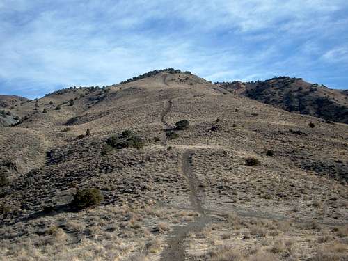
The main trail and the first lower summit (Point 5604)
Once at the top of first lower summit, continue following the wide trail as it fades in and out up and over several hills. Keep the true summit in your sites. Eventually you will head right, away from the true summit, up and over another hill. From there a jeep road will take you to the true summit.
Total elevation gain for this hike is about 1250 feet and depending where you park, it is anywhere from 2.5 miles to 3 miles round trip.