
|
|
Mountain/Rock |
|---|---|
|
|
39.37114°N / 119.53488°W |
|
|
Storey |
|
|
Hiking, Scrambling |
|
|
Spring, Fall, Winter |
|
|
7277 ft / 2218 m |
|
|
Overview
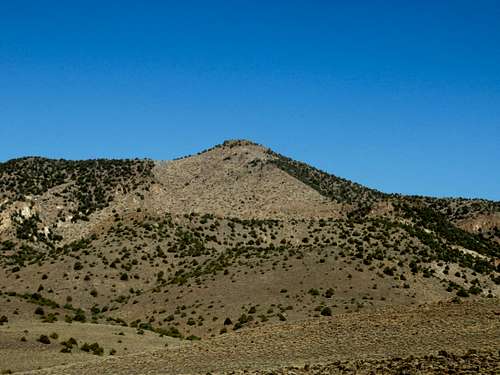
Tibbie Peak 7,277’ is a summit in the Flowery Range of Northwestern Nevada. It has two summits which look like a camel's back, making the mountain quite distinctive from a variety of vantage points. Only one of the summits, the east peak, is visible from the south approach off of US 50. The east peak is 40' higher than the west peak. The west peak is reached via a 25' Class 3 rock scramble that can be enjoyed during a visit to Tibbie Peak. Tibbie Peak has a little over 400’ of prominence, and it's clearly its own peak because most of that 400' goes straight up from the ridge below.
Tibbie Peak isn’t a popular mountain for hikers in the area. Although it really isn't that hard to reach it, very few ever do. This is probably because the more popular summits in the Flowery Range are closer to Virginia City.
Hiking Tibbie Peak can be done all year, but is recommended between October and April. Late spring and summer months are far too hot.
 Zoom shot of Tibbie Peak south face from the south
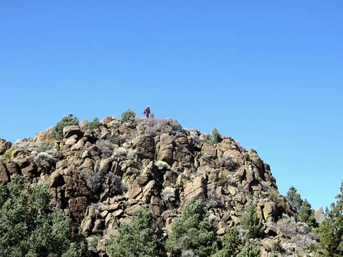 Looking up at the camel hump
Getting There
There are essentially three approaches to Tibbie Peak. One from the southwest, one from the northwest, and one from the south.
Southwestern route
The southwestern route is longer, but easier to get to from Reno and Carson City. The western route starts on a BLM access road hosting power lines, off of Six Mile Canyon Road. This road is accessed approximately mid-way between Virginia City and US 50. 3 ½ miles from either location. The road is at 39.315071, -119.58248.
From Reno, drive to Virginia City over the Geiger Grade (or US 50 from Carson City), and head east on Six Mile Canyon Road which heads downhill from Virginia City on the left. Drive past the Sugarloaf Rock Formation for 1 ½ miles. There are a couple roads near mining operations. One has a No Trespassing Sign. The one just past it has no such sign. There are large power lines at the base of the road. The road starts at only about 4770’.
From Carson City, take US 50 east towards Dayton. Six Mile Canyon is on the east side of Dayton, about 15 miles east of Carson City. Take a left on Six Mile Canyon and head up about 3 ½ miles. Park at the base of the road, or on the road.
Northwestern route
The northwest approach starts off Long Valley Road. This is accessed off of Geiger Grade, just north of Virginia City. From Reno, head towards Virginia City. Two miles north of town is a private road called Lousetown Road. Probably a few hundred people live on this road, so although it is private that does not mean it is off limits. The problem would be parking near the residential area. However, for Tibbie Peak, you take the main road, Lousetown Road, and after a little over a mile, take a right on Long Valley Road. Take this dirt road about 2 miles where it turns into Barrel Springs Road. You can take a 4WD far up the road and easily get to within three miles of the summit. But for those not wanting to rough it, they can park at the same access point for Rocky Peak and Horse Benchmark. To do this, continue straight for another 1/3 mile and park at 39.363, -119.5895 at about 6,030'. Note that there are a few homes and some nasty signs. But this area is visited by 4WD vehicles and you should be fine if you stay off private property.
Southern route
The southern route is accessed from US 50 up Neigh Road. Neigh Road is unmarked. There is a left turn lane if coming from the west onto Neigh Road. Neigh Road is a half mile past Chaves road when coming from the west. A 2WD can make it 1.5 miles up Neigh Road, and you can park here for a 7 ½ mile round trip hike if going the most direct route, or 9 1/2 miles round trip via a loop. If you want a shorter hike with less approach and even to do a double hike with the Flowery Range Highpoint 7,337’, it is advised you drive further. 4WD can comfortably make it another 1.5 to where my group parked at 39.3568, -119.5073 at 5,250’.
 4WD Trailhead
Route
Western routes
From the southwest, follow the power line road for about 2 miles at which point there is a turn heading right up towards the ridge towards Rocky Peak. The road zig zags up the ridge. After about a mile you hit a road on the ridge below Rocky Peak. Follow this road for another 1.5 miles until the road heads north down into the valley. A smaller road continues up and after a mile peters out. You are now one mile from the summit of Tibbie Peak, but you have to descend about 250’ before climbing back up to Tibbie Peak. All told this route is about 13 miles round trip gaining almost 2,900’ on the way to Tibbie Peak. The hike can include Rocky Peak and Horse BM and be around 14 miles round trip if you bag them on the way. Although this adds another 1,150' or so.
If taking the northwest approach, start at the aforementioned parking area. Head up to the ridge and you will reach a road just below. This road is on the ridge below Rocky Peak mentioned above. From here follow directions above to Tibbie Peak. A round trip hike up Tibbie Peak from here can be done in under 8 miles, with an elevation gain of about 1,600'. You can add Rocky Peak and Horse BM with another mile.
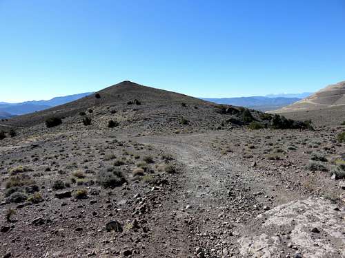
 View east to Tibbie Peak 7,277' from Horse Benchmark
Southern route
From the south, there are two options. One is to hike up to the ridge and approach from the east, and another is to head straight up the south face. The ridge hike is longer, but more scenic and offers an opportunity to include the Flowery Range Highpoint 7,337'. This can also be done as a loop. I have done it as a loop including the Flowery Range Highpoint, then taking the ridge to Tibbie Peak, and descending the South Face. I found it reasonably challenging, straightforward, and enjoyable.
If heading up the south face cut off the road after 2/3rds of a mile. There is a small road heading left. Take the road, which soon peters out, and head left towards the south face. You reach a ridge top after a little over ¾ miles. Then head up and over a hill and descend about 50’. You now have 920’ to hike up in ½ mile. This is better as an ascent route than a descent route. You will reach the summit in a little over 2 miles with an elevation gain of about 2,100’. Google Earth™ image of South Face route
If heading up to the ridge and approaching from the northeast, hike up the road for about 1.5 miles from the parking area noted above. The road heads generally northeast. A lesser road heads up the slope of the mountain range. It is hard to spot the turnoff, but an easy tell is that the main road descends at the turn off. So when the main road descends, take a left. You will see the lesser road heading up the slope. After about 1 ¼ miles the road ends at about 6,600’. Head up steeply to the ridge at about 7,000’ in less than ½ mile. Once on the ridge, there is a road. Take a right and continue for about ½ mile. Then there is ¾ miles to go to the summit.
For this route, which is longer, but much easier, the total distance one way is 4 ¼ miles with an elevation gain of 2,400.
If doing this as a loop, the total distance is about 6 ½ miles round trip.
Red Tape
Be cautious off Long Valley Road. There are many signs indicating people should not be there, but it could be interpreted that people must avoid crossing private property near any of the remote houses. Be respectful of private land and stay away from homes and steer clear of signs that prohibit access.