
|
|
Mountain/Rock |
|---|---|
|
|
39.35518°N / 119.55468°W |
|
|
Storey |
|
|
Hiking |
|
|
Spring, Fall, Winter |
|
|
7163 ft / 2183 m |
|
|
Overview
Horse Benchmark 7,163’ is a notable summit located east of Virginia City in the Flowery Range, an offshoot of the Virginia Range. It is among a series of rocky-topped peaks in the immediate vicinity, including Peak 7036, Rocky Peak 7,082’, and Tibbie Peak 7,277’Horse Benchmark is not frequently accessed, mostly due to its location hidden behind major view points from most of the Northwest Nevada population centers. It is in a unique spot, seemingly far from civilization, but in actuality, quite close to civilization by Nevada standards.
Located a few miles east of Virginia City, Nevada, a BLM access road leads to a ridge behind Horse Benchmark less than 5 miles from paved roads. A northern route accesses the peak in just over 3 miles.
Horse Benchmark is most easily and best hiked along with nearby Rocky Peak, as the two share a ridge that minimizes descent en route from Rocky Peak to Horse Benchmark.
Much of the surrounding area is on private lands, with "No Trespassing" signs near some old mining sites (some of which are occasionally active). This is often a deterrent to visitors who believe the entire area is off-limits. However, the route described below provides public access without trespassing on any of these lands.
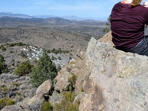
View North-Northwest from the summit
The best time to hike up Horse Benchmark and the Flowery Range in general is probably late fall (November, December) and late winter/early spring (February, March, April). During summer, temperatures are far too high. The area can get pretty snowy during the heart of winter, although Horse Benchmark typically sees less snow than the peaks further west.
Getting There
There are two direct routes to Horse Benchmark. The southern route starts on a BLM access road hosting power lines, off of Six Mile Canyon Road. This road is accessed approximately mid-way between Virginia City and US 50. 3 ½ miles from either location. The road is at 39.315071, -119.58248.From Reno, drive to Virginia City over the Geiger Grade (or US 50 from Carson City), and head east on Six Mile Canyon Road which heads downhill from Virginia City on the left. Drive past the Sugarloaf Rock Formation for 1 ½ miles. There are a couple roads near mining operations. One has a No Trespassing Sign. The one just past it has no such sign. There are large power lines at the base of the road. The road starts at only about 4770’.
From Carson City, take US 50 east towards Dayton. Six Mile Canyon is on the east side of Dayton, about 15 miles east of Carson City. Take a left on Six Mile Canyon and head up about 3 ½ miles. Park at the base of the road, or on the road.
The north approach starts off Long Valley Road. This is accessed off of Geiger Grade, just north of Virginia City. From Reno, head towards Virginia City. Two miles north of town is a private road called Lousetown Road. Probably a few hundred people live on this road, so although it is private that does not mean it is off limits. The problem would be parking near the residential area. However, for Horse Benchmark, you take the main road, Lousetown Road, and after a little over a mile, take a right on Long Valley Road. Take this dirt road about 2 miles where it turns into Barrel Springs Road. Continue straight for another third of a mile and park at 39.363, -119.5895 at about 6,030'. Note that there are a few homes and some nasty signs. But this area is visited by 4WD vehicles and you should be fine if you stay off private property.
Route
For the southern route, follow the power line road for about 2 miles at which point there is a turn heading right up towards the ridge towards Rocky Peak, which is visible the entire route. The road zig zags up the ridge. Views to Horse Benchmark are sometimes blocked by Rocky Peak.Either you can go around Rocky Peak, or cut through the lower parts of it and head over to Horse Benchmark, or you can simply do both peaks, which adds only about ½ mile total because they share a saddle. Horse BM adds about 600’ of gain from the saddle.
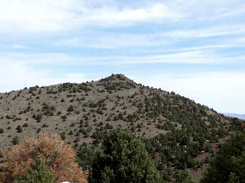
Approaching Horse Benchmark from the west
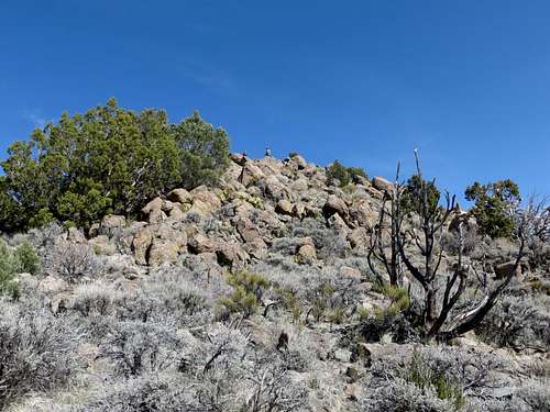
Just below the summit
If hiking both, the total round trip hiking distance is a little under 10 miles give or take, with an elevation gain of nearly 3,000’. Hiking just Horse Benchmark makes it about 9 1/2 miles round trip with an elevation gain of approximately 2,700’. This of course depends on the actual route taken, but this is a ballpark estimate.
For the north route, start at the aforementioned parking area. Head up to the ridge and there is a road below. There is a road going up towards Rocky Peak, reaching the summit in 2/3rds of a mile. From here you can add Horse Benchmark which is less than a mile away, and do both summits in about 6 miles total. Or you can stay on the main road, and not hike Rocky Peak. Take the road for a mile and head towards Horse Benchmark, which is a mile away. This way is about the same distance; 6 miles round trip, but is more straightforward. The elevation gain is half what it is from the Six Mile Canyon route.