
-
 18906 Hits
-
 88.08% Score
-
 26 Votes
|
|
Mountain/Rock |
|---|---|
|
|
43.16455°N / 109.60948°W |
|
|
Hiking, Scrambling |
|
|
Summer |
|
|
13540 ft / 4127 m |
|
|
Overview
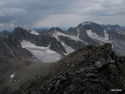
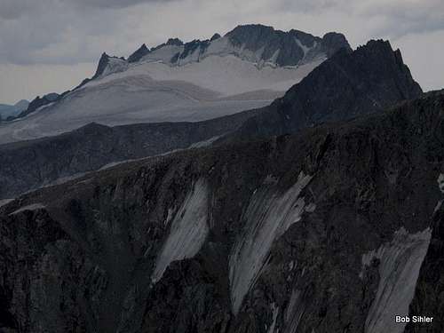
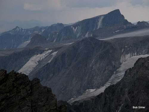
Situated on both the Continental Divide and the crest of the Wind River Range, Wyoming's most alpine range and home to the largest glaciers in the American Rockies, Dinwoody Peak itself is not that spectacular when seen from Titcomb Basin but has some of the most spectacular views imaginable, as the summit reveals a vast scene of ice, snow, and raw rock. It feels like a setting in another, wilder world; civilization feels far, far away. The view of Mount Woodrow Wilson and Gannett Peak with the expanse of the sprawling Dinwoody Glacier below is unforgettable. So is the view of Fremont Peak and the Upper Fremont Glacier.
"Dinwoody" is a name all over the place out here. In addition to the peak, there is a glacier, creek, ridge, and a group of lakes named for Dinwoody. There may be other features so named. So who was Dinwoody? He was Lt. William A. Dinwoodie of the U.S. Cavalry and once was stationed at Fort Washakie, which is in the Wind River Valley on the east side of the range. (Source: Guide to the Wyoming Mountains and Wilderness Areas, Orrin Bonney)
Looking for something nice to do on a day between harder climbs? Looking for something as an alternate because weather is making your longer, more committing route not look so good? Looking for a top-of-the-Winds feel but not looking for the exposure and the scrambling and/or technical climbing that often go with that?
Dinwoody Peak is waiting.
Of the 13ers in the Winds, it is likely that only Wind River Peak is easier than this one. If there is an easier 13er in Titcomb Basin than this one, I haven't heard of it; every other 13er there involves at least some Class 3 terrain. Dinwoody, despite Bonney's claim of Class 3, is only Class 2 by its easiest route. The summit block itself might be Class 3.
Bonney also suggests making Dinwoody part of the Triple Traverse, which also includes Doublet Peak and Mt. Warren. He calls this a Class 4 and 5 route with substantial amounts of ice and snow.
Getting There
Near the south end of Pinedale, turn east onto a signed road for Fremont Lake. Drive 14-15 miles to reach the Elkhart Park Trailhead.
For specific details, please see Bill Reed's page for Elkhart Park.
Route
This is the route Bonney covers in his book and which he calls Class 3. However, there are some important things for anyone using that book to know:
- He uses Wilson Meadows, not Titcomb Basin, as the approach. This makes the TH-TH RT distance closer to 50 miles than the 36 from Elkhart Park.
- Although he calls it an 8-hour RT hike from Wilson Meadows, a look at maps suggests that glacier travel is involved in order to reach Bonney Pass.
I am covering the route from Elkhart Park instead.
Start from Elkhart Park, about 9400', and hike 10.5 mi to Island Lake, about 10,400'. While this sounds like one of the world's easiest backpacking approaches, it is more strenuous than it sounds, for the route does not ascend a drainage or other naturally ascending line but rather has several dips and re-climbs that make the total elevation gain closer to 2000' (still not that bad but frustrating nevertheless). And the first 5 miles are almost exclusively extremely dull hiking through lodgepole pine forest with no views of anything except more lodgepole pines.
Although there are several trail junctions along the way, with a good map and decent reading comprehension, you will not have trouble following the correct route.
Where you camp is up to you based on your itinerary. Island Lake makes a good base camp because routes to Titcomb Basin, Indian Basin, and other areas nearby all branch out from it. If you don't camp at Island Lake and if Titcomb Basin is your primary destination, then consider the extra hike into the basin to set up camp. However, be aware that finding good legal campsites in lower Titcomb Basin is tricky because you are required to camp at least 200' from lakes. Also, there is very little shelter in Titcomb Basin, and wood fires are not allowed.
This route description starts from Island Lake where the trail drops down and reaches the shore there. RT distance from this point is about 15 miles with approximately 3200' of elevation gain. Almost all of the day will be above timberline, so keep that in mind as you watch the weather.
From Island Lake, hike another mile to a signed junction. In August 2012, the sign indicated Indian Pass was 6 miles along the right fork (seems a bit too long, though). You want to go left, immediately crossing the stream draining Indian Basin and shortly thereafter entering famous and spectacular Titcomb Basin.
 |  |
A good trail leads about three miles along the eastern sides of the three main lakes of Titcomb Basin, gaining little elevation as it does so. Beyond the last lake, the trail starts to fade. Although it reappears at times and there are sometimes cairns marking the way, neither the trail nor the cairns are really necessary; Bonney Pass, your next destination, is obvious. Whenever possible, though, use existing trails or go over bare rock to minimize impact on the fragile tundra ecosystem out here.
It is 3-3.5 mi from the head of the upper lake to Bonney Pass. Elevation gain is 2200', a moderate grade overall, but be aware that the last mile gains about 1400'. Even though it is just a hike up talus, it is very steep, and when you consider that climbing Gannett Peak from Titcomb Basin typically means a summit day including this pass and a descent of over 1000' from it and then dealing with it all over again on the return, you understand why many climbers choose to approach via the Glacier Trail even though that way is longer. Anyway, as you get closer to the pass, a more defined use trail does develop, but I am not so sure it is worth using; the footing is really loose much of the way, and larger rocks and slabs nearby offer better purchase. The use trails do speed things up on the way down, though.
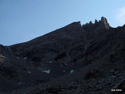
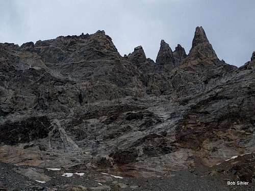
After you gape at the views from Bonney Pass (you actually have to wander a short distance north and down to appreciate the best of them), head directly up Dinwoody's west ridge, which eventually bends southeast, to the small summit block, which is in a location that is surprisingly narrow and exposed (but not frighteningly so, in my opinion). Check out the dilapidated register.
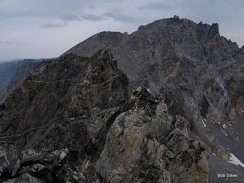
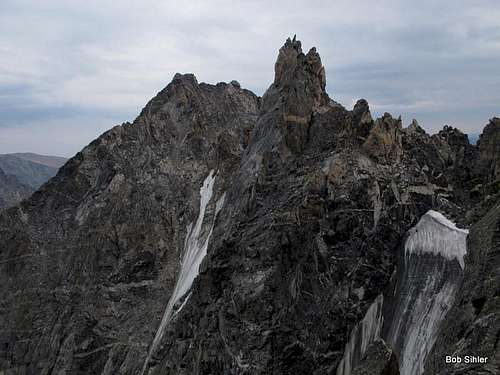
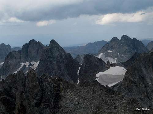
It's pretty hard to beat the views without climbing something much harder. In addition to the aforementioned standout views of Woodrow Wilson, Gannett, Fremont, and their surrounding glaciers, there are also incredible views of Titcomb Basin and many of its peaks. Doublet Peak is very close and very imposing and very alluring, but the way there also looks quite exposed, challenging, and rotten.
 |  |  |
 |  |  |
Bonney also mentions an East Face route that goes at 5.2. It ascends from the col between Dinwoody Peak and Doublet Peak. The approach would require glacier travel.
Red Tape
Just read posted wilderness regulations, especially regarding campsites and fires.Technically, this part of the Winds is grizzly country again, but I'm not sure if any have been seen in this area. If any have been, it has been exceedingly rarely.