
-
 4242 Hits
-
 78.27% Score
-
 9 Votes
|
|
Mountain/Rock |
|---|---|
|
|
43.15801°N / 109.63°W |
|
|
Hiking, Mountaineering, Trad Climbing, Scrambling |
|
|
Spring, Summer |
|
|
13220 ft / 4029 m |
|
|
Overview
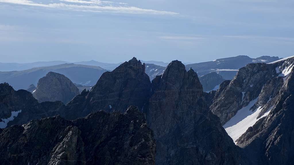
Spearhead Pinnacle is another one of the Wyoming 13ers (see the list here) that barely has 300 feet of prominence to be included in the list, but it's a good thing it is. This tower is an exceptionally fun one, offering a low 5th class route to the top (which makes the WY 13ers list even more difficult). Some people have up-climbed this peak solo without the use of a rope, but made short rappels coming down, while most will opt to at least simul-climb. Described below is what I believed to be the best gear selection taking into consideration the remote nature of this peak (meaning you want to carry as little as possible). Immediately to the south of Spearhead is a slightly shorter tower called Forked Tounge that has virtually no information about it anywhere apart from a sentence or two in the Kelsey Guide. First ascent potential is found on these spires, which have impressive east faces. The easiest route for either of them is by their cooresponding north ridges. Reaching the base of the north ridge of Spearhead is much easier though, and is described in the route description below.
Getting There
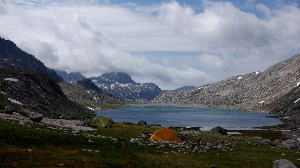
Use the Elkhart Park Trailhead accessed from Pinedale on the west side of the range and hike the Pole Creek Trail to Island Lake, passing by Photographers Point and Seneca Lake along the way. Just after passing over a small divide at 10,660 feet Island Lake will come into view. Descend to it and continue to the junction with the Titcomb and Indian Basin trails. Take the Titcomb Basin Trail heading north/leftward and hike past Lower and Upper Titcomb Lakes as the trail follows along their east shores. Base camp can be set up about 0.5 mile past the upper lake where many rock shelters have been built by Gannett Peak climbers and other backpackers.
Route - North Ridge Class 5.3
There is really only one feasible route up Spearhead, with its only weakness being the north ridge. All other sides are likely inaccessible to most people except the strongest of rock climbers and alpanists. Approach from Titcomb Basin and continue north up the valley as if you were heading to Bonney Pass. You will pass below and around the very steep west face of the towers of Mount Helen, then pass below the base of the prominent NE couloir that shoots straight up to the upper north face of Helen. Shortly after passing the base of this inspiring couloir, you will see another couloir/gully that heads up to the low 12580 foot saddle bwtween Helen and Forked Tounge. This is the next gully north of the steeper NE couloir. Ascend this, which starts as a gentle open slope, but narrows into a 35-40 degree couloir (which will be snow covered on the lower 2/3 most of the summer) until you reach the saddle. The views to the east are particulairly nice at sunrise.
At the saddle, drop 100 feet or so to the east side and cut north, traversing the snow around the east side of the towers, eventually curving back west to make the 400 foot ascent back up to the saddle at the base of Spearhead's north ridge which has an elevation of 12,920 feet. Use caution when climbing up the last bit of this slope to the saddle as the rock is very loose.
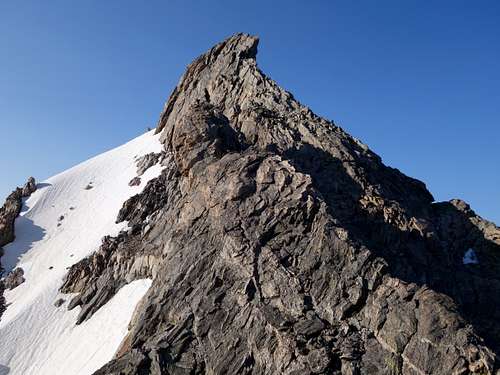
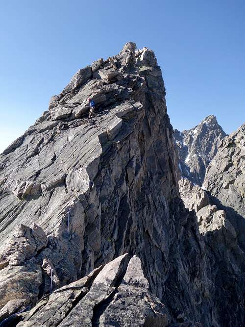
Turn back to the south and begin scrambling the crest of the north ridge, popping over a small bulge initially (requiring a 20 foot class 3 descent on the other side). The ridge steepens up considerable about 120 feet above the saddle, where you can find a nice ledge at the base of the initial rise to rack up if using gear. The rest of the route begins as a 5.0 climb on the exposed crest up a series of cracks, then eases back to 4th class when it traverses onto a ledge system on the left (east) side of the crest. At the end of this ledge system, after perhaps 50 horizontal feet or so, is the crux class 5.3 step. A near vertical 25 foot rise up a large flake takes you to much lower angle, walkable slabs above, where a large boulder with rappel cord slung around can be found. There are plenty of holds to climb this section, but the feet are a little tricky during the first couple moves up the step. Just beyond the boulder anchor, the ridge narrows into a true knife edge and requires you to grab the sharp crest with your hands and smear your feet on the 45 degree angle rock slabs on the east side, and shimmy over a horizontal distance of about 50 feet. After that it's an easy class 2-3 walk to the final summit pinnacle. Options for small cams can be found along the knife edge if protecting it is desired, as a fall would definitely be deadly. My partner and I did one long simulclimb pitch from the first ledge mentioned above where the ridge initially steepens, to another nearly flat section a few meters from the summit pinnacle.
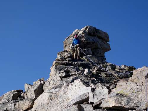
Topping out on the summit pinnacle is a simple 4th class move or two, but it's very exposed on nearly all sides. I was comfortable soloing it up and down though, as no anchor exists on the summit. From the top (which is only really large enough for one person to sit comfortably), you can clearly see Forked Tounge is the lower of the two towers, and a tiny glass jar summit register is found, placed by none other than Sarah and Teresa many years prior. No one signed it since there visit until the year 2020.
Descending Spearhead involves retracing the route back across the knife edge ridge. If rappelling the crux step is desired, a single 30 meter rope will get you down it, and just barely reaches the ledge system on the east side that you can then simul-downclimb the initial 4th and 5.0 rise. Or if you have a 60 meter rope (or two 30s,) you can make it all the way down to the ledge at the start of the technical climbing on one rappel from the boulder anchor. During our visit in July 2020 we improved this anchor.
A single rack of cams up to 2" and a few nuts more than sufficed. Small cams were generally more useful, as the knife edge section only had pro options for stuff under 0.4".
Red Tape/Camping
No red tape. Great Camping can be had 0.5 mile above upper Titcomb Lake, or near the junction of the Indian/Titcomb Basin Trails.
When to Climb
Best time for summer conditions will be July - Early September. Ski touring would be advisable before June. The initial hike towards Seneca Lakes dries out a little earlier, but tons of snow typically persists in Titcomb Basin past July 4th, but will normally dry out reasonably well shortly after mid July.
Map
This map shows the route up Spearhead Pinnacle with a blue line from a typical camp in Titcomb Basin. Combining with Mount Warren via the Class 3 south chute route is also displayed.
External Links
My Trip Report of Spearhead Pinnacle, and all the other 13ers in the Wind Rivers