
|
|
Mountain/Rock |
|---|---|
|
|
34.80190°N / 111.3901°W |
|
|
Coconino |
|
|
Hiking |
|
|
Spring, Summer, Fall, Winter |
|
|
8532 ft / 2601 m |
|
|
Overview
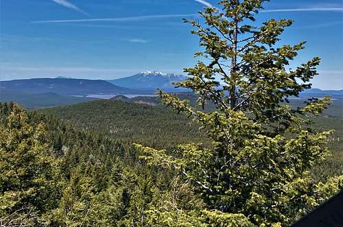
Hutch Mountain is the highest summit of the Mormon Plateau within the large tract of Coconino National Forest land located southeast of Flagstaff and east of the Interstate-17 corridor. This is the southern extent of the San Francisco Volcanic Fields, and the topography here is testament to the volcanism that created it - rolling terrain and rounded summits of cinder and pumice. The same volcanic activity that created the peaks also created natural depressions - creating two of Arizona's very few natural lakes. Mormon Lake is close by and is Arizona's largest natural inland body of water, although it is usually a big mudfield, while Stoneman Lake is smaller and located in a natural crater/depression, covering maybe 20 acres. Migratory birds use these lakes as waypoints on their various bird journeys.
This section of the Coconino National Forest is well off the usual beaten paths, and even on hot summer weekend days, you'll feel like you have plenty of elbow room. There will be people - it's not that anonymous - but it is rarely overcrowded and certainly less so than some areas closer to Flagstaff. The land here generally ranges in elevation between 6,000 feet to as high as 8,532 feet - Hutch Mountain's summit. In summer when the deserts are baking, the weather up here is pleasant and maybe warm, but never overly hot. In winter, snow covers the ground but snowstorms are often spaced out over many weeks. Unless it has just snowed, access should not be a problem. The forest is predominantly mature ponderosa pine, with pleasurable meadows spaced throughout of low grass.
Thank you to Scott Surgent for this overview and the remaining details.
Getting There
A good forest road leads almost all the way to the summit of Hutch Mountain and a decommissioned lookout tower. It can be (mostly) driven but there are good options to make a nice half-day hike of the peak. To get there:
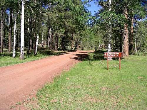
From the north via Flagstaff: Take Lake Mary Road southeast and stay on it as it becomes Coconino National Forest Road 3, which is paved for its entire 50+ mile length until it meets state highway AZ-87 to the south. Drive approximately 37 miles (going by the signs) to the Hutch Mountain Lookout Road (FR-135) on the east side of the road. Drive the road for about 2.5 miles up into the forest to another signed junction, where the sign says "Hutch L. O. - 2". There is a pull-out for parking here.
From the South via Phoenix and Interstate-17: Drive north on I-17 to the Stoneman Lake exit. Drive east on Stoneman Lake Road to a T-junction at about 7 miles (the pavement end just before the T-junction). Bear left, now on FR-213. Stay on FR-213 until it meets FR-3. Go left (north) one mile to the Hutch Road on your right. FR-213 is unpaved but passable by all vehicles when dry. Stoneman Lake itself is just off the road via some spur roads.
From the south via Payson: Drive the "beeline" highway, AZ-87, north through Payson and continue north through Strawberry, Pine and Clints Well to the junction of FR-3 on the left. Drive north on FR-3 about 21 miles to the Hutch Mountain Road. The Happy Jack Ranger Station is at about mile 18.
 You are getting warmer...
Red Tape
There are no fees to camp or hike. Be mindful of fire restrictions in the summer.
You'll come for the peak, stay for the camping!
This is a car-camper's heaven! There are hundreds of great sites located off the innumerable forest roads in the region. Most roads are in decent condition. Some roads are rougher and you can make yourself more hidden by going down one of these roads where the bigger camper vehicles can't. In any case, it's unlikely you'll feel crowded, and if you do ... go somewhere else!
There is some camping right at the FR 3/135 (Hutch Mtn Road) junction, ideal for big trailers. Higher up, the road is a tad rough (but still 2wd passable). There are excellent sites everywhere. We found a wonderful site on the south slopes of the peak and camped there for the night.
The "climb"
This is an easy peak to attain. If you park near the base of the peak, it's an easy 1.5 mile one-way walk up the road to the summit area. The gradient is very moderate. Forest cover is heavy but views are nice in the breaks.
The summit is saddle-shaped: the west point is 8,518 feet and the east point is the summit, 8,532 feet. At the saddle, the road to the summit and lookout may be gated shut, but it's an easy quarter-mile walk to the top. The lookout itself seems not to be in use and is borderline in quality - the steps are wood planks and not necessarily fastened solidly to the metal structure. As of May 7, 2023, the lookout tower was closed at the top; although one could walk all the way up to just below the top of the tower, with much better views than at the bottom of the tower.
I also walked to the western summit bump. The views here are mostly blocked by trees and a small building.
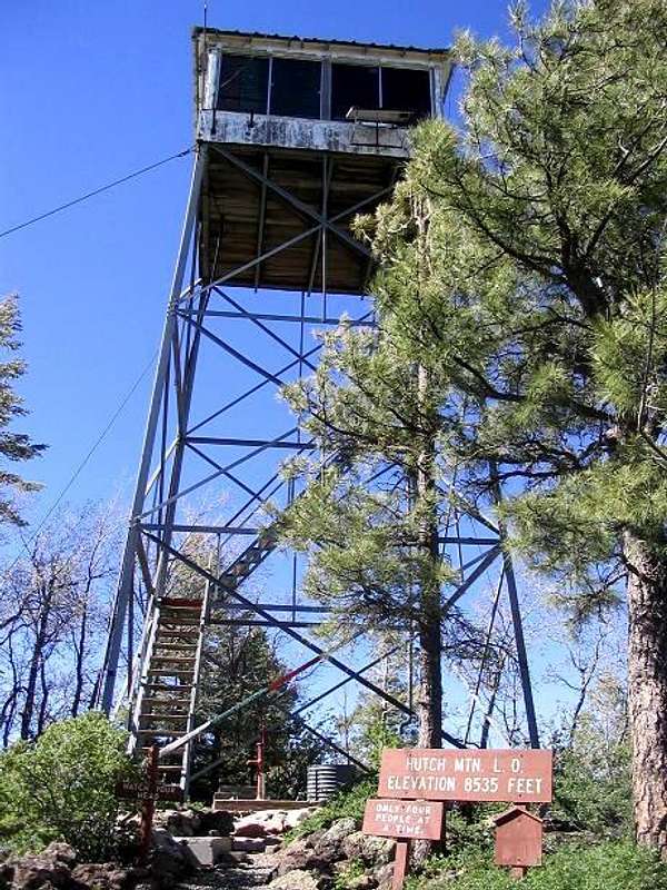 The lookout tower atop Hutch.
Summer thunderstorms are common in July-September, so use common sense during this time. Mornings are usually best as the storms brew in the afternoons.
Winter snow could make for an interesting hike or possibly a cross-country ski approach.
External Links
Hutch Mountain Trip Report (www.surgent.net)