
-
 17955 Hits
-
 83.1% Score
-
 16 Votes
|
|
Mountain/Rock |
|---|---|
|
|
45.92060°N / 7.55859°E |
|
|
Italy-Swiss |
|
|
11782 ft / 3591 m |
|
|
Overview
What's new:
- Jul 13th, 2017 Inherited the page from Andrea.it.
- Aug 11th, 2017 Started to modify the page and the other sections.
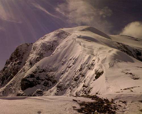
Massive and rocky mountain. The origin of the name "Brulè'", or better Braoulé, is unknown, but it should be linked to the name "Breuil", which means "marécageux", Swampy if not quite marshy, in the local old lenguage or "patois". In fact, the Southeastern flank dominates above the marsh at the and of the lake Places Moulin, even Places des Moulins. It's composed by three flanks. The Eastern that rising above the Comba Tza de Tzan(which is the head of Val Pelline or Valpelline), the Northern Wall covered of ice and descending towards Arolla along the Haute Arolla Glacier; and the Southwestern icy Face where the Brule' Glacier is placed between this mountain and the Becca Vannetta. It is not a very important summit, but could be interesting for the view to the majour mountain around there, like Dent d'Herens and Grandes Murailles.
Montagna massiccia e rocciosa. L'origine del nome "Brulè" o, e meglio, Braoulé è sconosciuta, ma dovrebbe essere legata al nome "Breuil", il che significa "marécageux", ovvero piuttosto acquitrinoso se non proprio paludoso, nel vecchio lenguage locale o "patois". Infatti, il fianco Sudorientale domina sopra la palude ad Oriente del Lago di Place Moulin od anche di Places des Moulins Places Moulin. È composto da tre versanti. L'Orientale che sorge sopra la Comba Tza de Tzan (che è alla testata della Valpelline o Val Pelline), il fianco Settentrionale coperto di ghiaccio e discendente verso Arolla lungo il Ghiacciaio Haute Arolla; infine il Sudovest, dove si trova il Ghiacciaio di Brulé o Braoulé, tra questa montagna e la Becca Vannetta. Non è una sommità importantissima, ma potrebbe essere interessante per la vista verso le montagne circostanti, come la Dent d'Herens e le Grandes Murailles.
First Ascents
- West-northwest Ridge (Standard Via): Unknown, in descent Alphonse Chambrelent, André and Edouard Michelin, Pierre Puiseux, Bernard and Marc Wolff without mountain guides, Aug 06th, 1892.
- North Wall (Right Route): Jacques and Olivier Barbey with Constantin Topali, Jul 23th, 1923.
- North Wall (Direct Route): M. Brandt, J. Braun, A. Meyer, R. Theytaz and M. Zuchschwerdt, Jun 27 th, 1965.
- Northeast Crest (First Via): Arthur Cust with a mountain guide unknown, Aug 07th, 1876.
- Eastern Wall (Tsa de Tsan Route): Scipione Borghese with the mountain guides Alexis Brocherel and Adolphe Chenoz, 1912, in ascent, not repeated route.
- Southern Ridge (from Mont Braoulé Glacier): Julien Gallet with the mountain guides Antoine Bovier dad and son, Jul 15 th, 1896.
- Western Face (Direct Via from Braoulé Glacier): Osvaldo Cardellina, Sandrino Casalegno, Maurizio Castellan, Marco Cossard and Giuseppe Lamazzi, Jul 15th, 1984, in ascent with Direct Variant in the last 220 metres.
- Northeast Crest and Western Face (to Braoulé Glacier): Gino and Silvia Buscaini, Jul 23th, 1969, in descent.
Getting there
Area reachable from Italy and Swizzerland.
Route from ITALY: Via Valpelline-Comba d'Oren-rif Nacamuli.From Turin, Milan. Leave motorway A5 in Aosta Est, then follow Grand Sant Bernard tunnel direction. Once passed Valpelline village, take the direction to lake of Place Moulin.
Route from SWIZZERLAND: Via Arolla.From Geneva, Sion. Arolla is the topmost village of the uppermost valley of the Val d'Hérens. In former times, you could reach it only on foot. Now, there exists a road. You reach Arolla by car from Sion via Evolène and Les Haudères.
Standard & others Routes
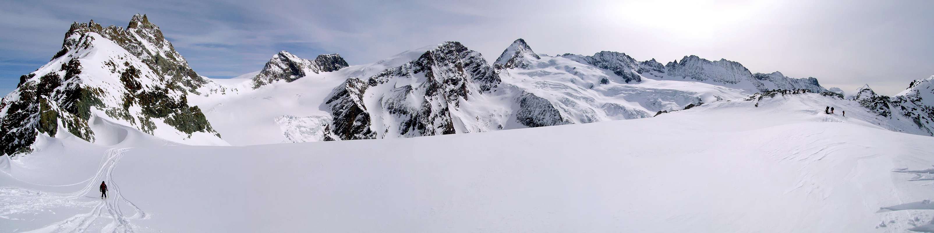
Very good place fo ski-mauntaineering. The very famous "hauteroute" Chamonix-Zermatt, passes through this region with many variants.
Ottimo posto per lo sci-alpinismo. Il famoso percorso "hauteroute" Chamonix-Zermatt, passa attraverso questa regione con molte varianti.
- West-northwest Ridge (Normal Route): from Nacamuli Refuge towards the Col Collon (2.818m) and across Punta Kurz (3.496m) by the border crest with caution to the snowy corniches, before to the right (until Punta Kurz), after left from the large saddle between the two Summits. 2h'00/3h'00. Difficulty F+/BSA.
- North mixed Wall: Both dangerous routes. Done very rarely. Not easy to find the way through crevasses and serracs. Long 450m and 54° of maximum inclination. Some passages of III°/IV°. Difficulty D/TD.
- Northeast Crest: Wild environment, not the best cause the bad quality of rocks.
- Eastern rocky Wall: Dangerous route, for rocks falls. Not repeated via.
- Southern Ridge: Very long and not very recommended.
- Western icy Face: Route not very interesting and usually done descending from the top with ski. Long around 300 metres with 33°/35°/40° slope in descent; difficulty in descent BSA or F+ and PD-/AD-. The direct route, long about 500 metres, is more interesting with slope in ascent of 42°/38°/36°; OSA or AD/PD+/PD.
Gear
For Mountaineering with rope, ice-axe and crampons.
Da Alpinismo con corda, piccozza e ramponi.
Camping
Remember that free camping is forbidden (except for emergency reasons, over 2.500m, from darkness until dawn).
Refuges and Huts
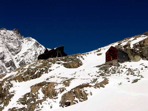 |
Italian side REF. NACAMULI-COL COLLON 60 places, (2.818m) at the head of Comba d'Oren, 3h'00/4h'00 from the dike of Place Moulin. Open summer and spring for ski-mauntaineering. Difficulty EE.
Swiss side REF. DES BOUQUETINES 25 places, (2.980m) at the head of Glacier d'Arolla. 3h'00/4h'00 from Arolla. Open summer. Tel. 0041218456321. Difficulty F. CABANE DES VIGNETTES 125 places (3.160m), situated near the "Col des Vignettes". 3h'00/4h'00 from Arolla. Tel. 0041272831322. Open summer and spring. Difficulty F.
Mountain Conditions
- You can get meteo information at the official site of the Regione Valle d'Aosta:
- Valle d'Aosta Meteo
Webcam
- WEBCAM on Aosta Valley:
- Webcam
Books and Maps
BOOKS:
- "Guida delle Alpi Occidentali", di Giovanni Bobba e Luigi Vaccarone C.A.I. Sezione di Torino Volume II (parte II), 25 Maggio 1896.
- "Guida dei Monti d'Italia-Alpi Pennine" (Vol. I°) di Gino Buscaini-Club Alpino Italiano/Turing Club Italiano, Luglio 1971 (in Italian).
- "Diari Alpinistici" di Osvaldo Cardellina e Indice Generale accompagnato da Schedario Relazioni Ascensioni 1964-2019 (unpublished).
- "Guida della Valpelline" de l'Abbè Joseph-Marie Henry - Societè Editrice Valdotaine 1925 II Edition e Collana Reprint Musumeci (1986).
- "Rifugi e bivacchi in Valle d'Aosta" di Cosimo Zappelli aggiornata da Pietro Giglio. Musumeci Editore, Luglio 2002 (in Italian).
 |
 |
 |
MAPS:
- Kompas "Breuil Cervinia Zermatt" Sentieri e Rifugi Carta turistica 1:50.000.
- L'Escursionista "Valpelline, Saint Barthélemy" (carta n° 6) 1:25.000.
- I.G.C. Istituto Geografico Centrale "La Valpelline, Ollomont, Saint Barthélemy", (carta n° 115) Map1:30.000.
- Carta Nazionale Svizzera "Foglio Valpelline" 1:50.000.
Important Information
- REGIONE AUTONOMA VALLE D'AOSTA the official site.
- FONDAZIONE MONTAGNA SICURA Villa Cameron, località Villard de la Palud n° 1 Courmayeur (AO) Tel: 39 0165 897602 - Fax: 39 0165 897647.
- SOCIETA' DELLE GUIDE DELLA VALPELLINE Etroubles-Strada Nazionale, n° 13 - Tel +39 0165 78559 - Valpelline-Loc Capoluogo, n° 1 - Tel +39 0165 713502 (AO) Italia.
- A.I.NE.VA. (Associazione Interregionale Neve e Valanghe).
Useful numbers
- Protezione Civile Valdostana località Aeroporto n° 7/A Saint Christophe (Ao) Tel. 0165-238222.
- Bollettino Meteo (weather info) Tel. 0165-44113.
- Unità Operativa di Soccorso Sanitario Tel. 118.