
-
 8122 Hits
-
 87.31% Score
-
 24 Votes
|
|
Mountain/Rock |
|---|---|
|
|
45.91060°N / 7.33097°E |
|
|
Mountaineering |
|
|
10869 ft / 3313 m |
|
|
Overview
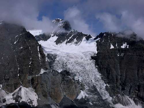
Rocky top is not very busy border post on the ridge that rises between the Grande Tête de By and Mont Avril. Excellent vantage point below the Grand Combin and Mont Durand Glacier and excellent views to Southeast on Mount Gelé/Mount Morion Mountain Chain and to soaring Fiorio Point.

Cima rocciosa molto raramente frequentata, posta sulla cresta di confine che si eleva tra la Grande Tête de By e il Mont Avril. Ottimo punto panoramico sul Grand Combin e sul sottostante Glacier du Mont Durand, nonché verso SE sulla Catena Mont Gelé/Mont Morion e sull'ardita Punta Fiorio.
First Ascents
- First on the summit (Frontier W Crest): Abbots Joseph Henry and V. Anselmet, (Aug 03th, 1911).
- In winter: Unknown.
- N Side: Umberto Balestrieri Piantanida and Ugo di Vallepiana, (Aug 16th, 1924).
- E-NE Arête (to and from Mont Avril Pass): Abbot Joseph Henry and Abbot V. Anselmet, (Aug 03th, 1911), in descent and in ascent.
- SW Side: Abbots Joseph Henry, V. Anselmet, (Aug 03th, 1911), in descent.
- S-SE Edge of Antesummit East (3.295/3.000m~) and E Ridge: Osvaldo Cardellina, lone, (August 13th, 2003), in ascent.
- SE Wall (from and to "hanging plateau"): Osvaldo Cardellina, Emilio Bertona and Gianfranco Vicentini (these two partially, in initial of ascent two/third part), (August 13th, 2003), in descent.
- * Integral crossing (from Mont Avril to Filon's Head): Osvaldo Cardellina, (Oct 23th, 1983).
Getting There
BY CAR:- From Torino, Milano, etc: Motorway A5. Exit at Aosta Est.
- From Switzerland: through the Grand Saint Bernard Tunnel or the namesake pass.
- From France: through the Mont Blanc Tunnel or Petit Saint Bernard Pass. It is not necessary to take Motorway A5: you can drive on SS.26, in the direction of Aosta.
BY PLANE:
- Aeroporto Internazionale "Corrado Gex" Saint Christophe (Aosta).
 |
Itinerary
From Aosta East exit of the motorway, follow along the SS.27 for the Gran San Bernardo Tunnel After about ten KM turn to the right toward Valpelline (964m), creoss it and turn to the left to get Ollomont (1.335m) and the small built area of Glacier (1.549m), where you must start walking.
Dall'uscita del Casello Autostradale di Aosta Est, proseguire sulla SS.27 in direzione del tunnel del Gran San Bernardo; dopo circa un decina di chilometri svoltare sulla destra verso il Paese di Valpelline (964 m). Dopo averlo superato svoltare sulla sinistra e raggiungere il Paese di Ollomont (1.335 m); proseguire sino alla Frazione di Glacier (1.549 m), dove inizia l'itinerario a piedi.
Approach
From Glacier also Glassier (1.549m) take the mule track to By before the bridge and follow up to Farinet House, where you must turn right branch toward Fenêtre Durand. Follow the dirt road up to the Alpe Balme de Bal (2.128m); along the mule track n° 5, or along the dirt road, to the Alpe Lombardin (2.309m) and, about 200m before, arriving there go to the left up to the Filon Baite (= Alp) (2.476m).
Da Glacier o Glassier (come nel cartello del villaggio) (1.549 m) prendere la mulattiera prima del ponte, che sale a By, seguendola sino alla Casa Farinet, ove si prende il ramo di destra per la Fenêtre Durand. Portarsi sulla poderale e seguirla sino all'Alpe Balme de Bal (2.128 m); dall'alpeggio per la mulattiera n° 5, o per la strada poderale, dirigersi verso l'Alpe Lombardin (2.309 m) e, 200 metri prima dell'alpeggio, risalire sulla sinistra sino alle Baite du Filon (2.476 m).
Routes
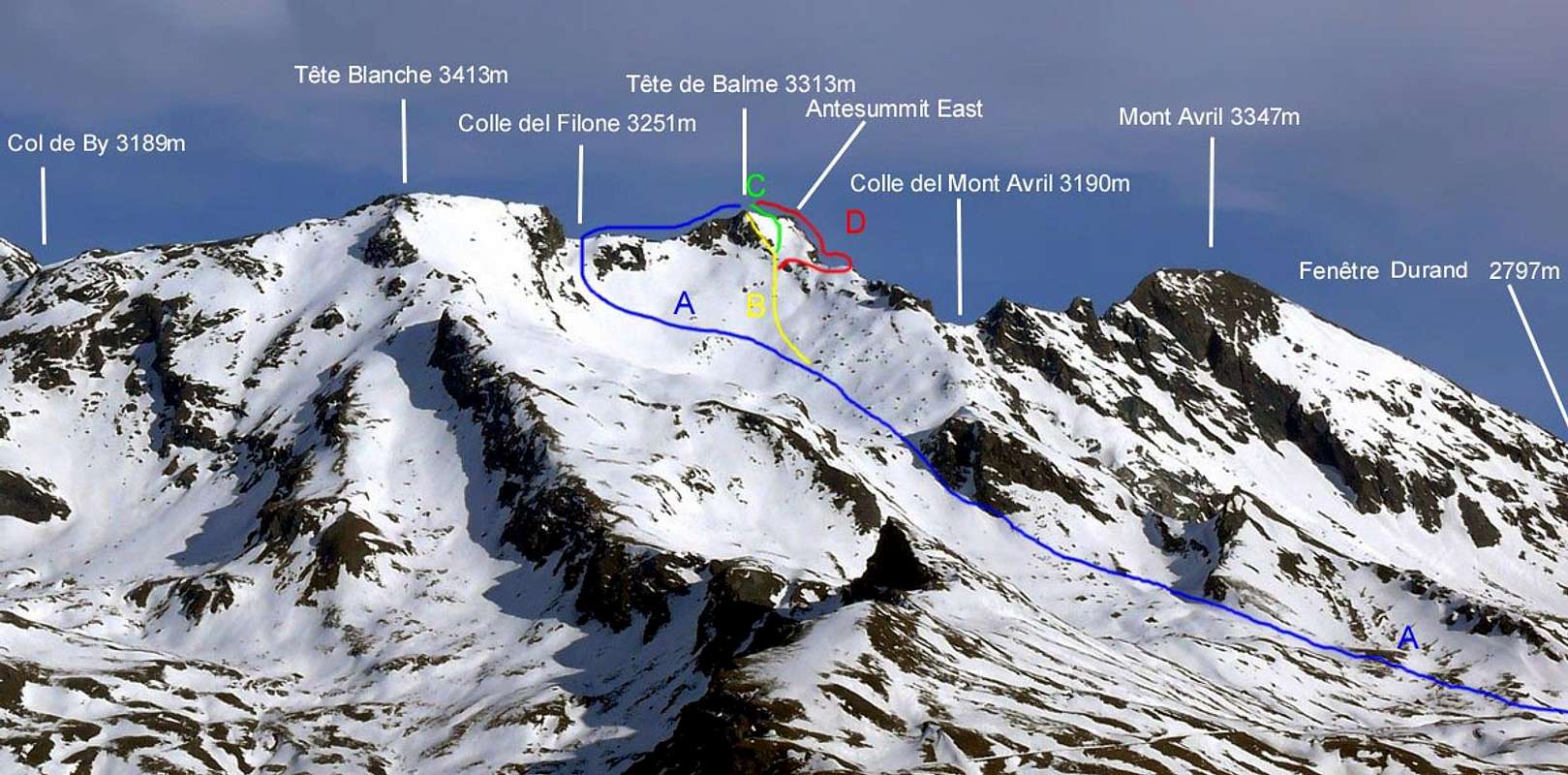
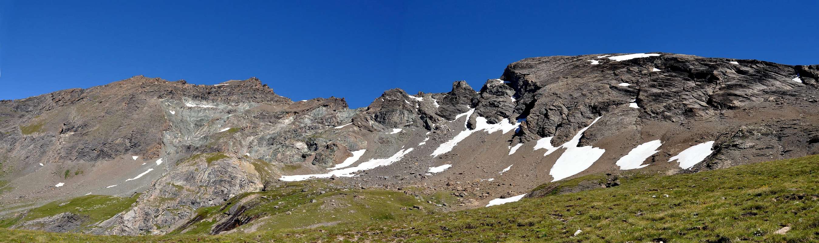
Route A) - From Filon Pasture (2.478m), by tracks of grazing and North-northwest direction go up to Filon Plan (= Filon Tableland) and along the small torrent reach a narrow rocky strip, in quota 2.825m; easily to get over left and to go in a little valley by rubbles, debris and a typical snowfield with a great blocks series, usable for "salle à manger". Leaving in left the route to Bonne Mort Crest (= Good Death Crest, name consequent the ancient battles between of Aosta Valley and Valais, property pastures motive), go up directly to Filon Pass (3.251m). From pass and, by brief but narrow West Ridge. easily to Summit (F+/PD-; I°+/II°-; 2h'15; 0h'15 from pass; more and more rarely popular route, maybe even by hunters, but logic)
Via A) - Dall'Alpeggio del Filone (2.478 m), inoltrarsi a Nord-nordovest su tracce da pascolo sempre più ripide portandosi, a sinistra del torrente, in un ripiano con detriti, frantumi, blocchi ed un caratteristico nevaio dal quale "emergono" grandi blocchi, molto atti a salle à manger. Lasciando a sinistra la via per la Cresta della Bonne Mort (teatro di battaglie nel passato per la proprietà dei pascoli tra le popolazioni valdostane e del confinante Vallese), salire direttamente e con le stesse peculiarità al Colle del Filone (3.251 m), non prima di aver aggirato una piccola fascia rocciosa a sinistra contro l'omonima punta a quota 2.825 m~. Da questo brevemente ed abbastanza facilmente alla Vetta, tramite la Cresta Ovest (F+/PD-; I°+/II°-; 2h'15; 0h'15 dal colle; via veramente molto raramente frequentata, forse neppure dai cacciatori, ma logica).
Route B) - By previous route and same peculiarity continue up to 3.100m~ and, through a right diagonal and by a scree and rocky slope, reach a very small fork or saddle; by a brief, but unsafe and vertical falls ((II°+/III°-), climb up the short ridge that leads quickly to the top (PD/PD-; 2h'30/3h'00).
Via B) - Con la via precedente continuare sino alla quota 3.100 m~ e, con diagonale sulla destra e per pendii detritici e rocce poco sicure, salire sulla breve ma ripida Cresta Sud presso una caratteristica forcella; da questa, superando due brevi ma verticali tratti (II°+/III°-) nonché rocce più facili nell'ultima parte, raggiungere la Vetta (PD/PD-; 2h'30/3h'00).
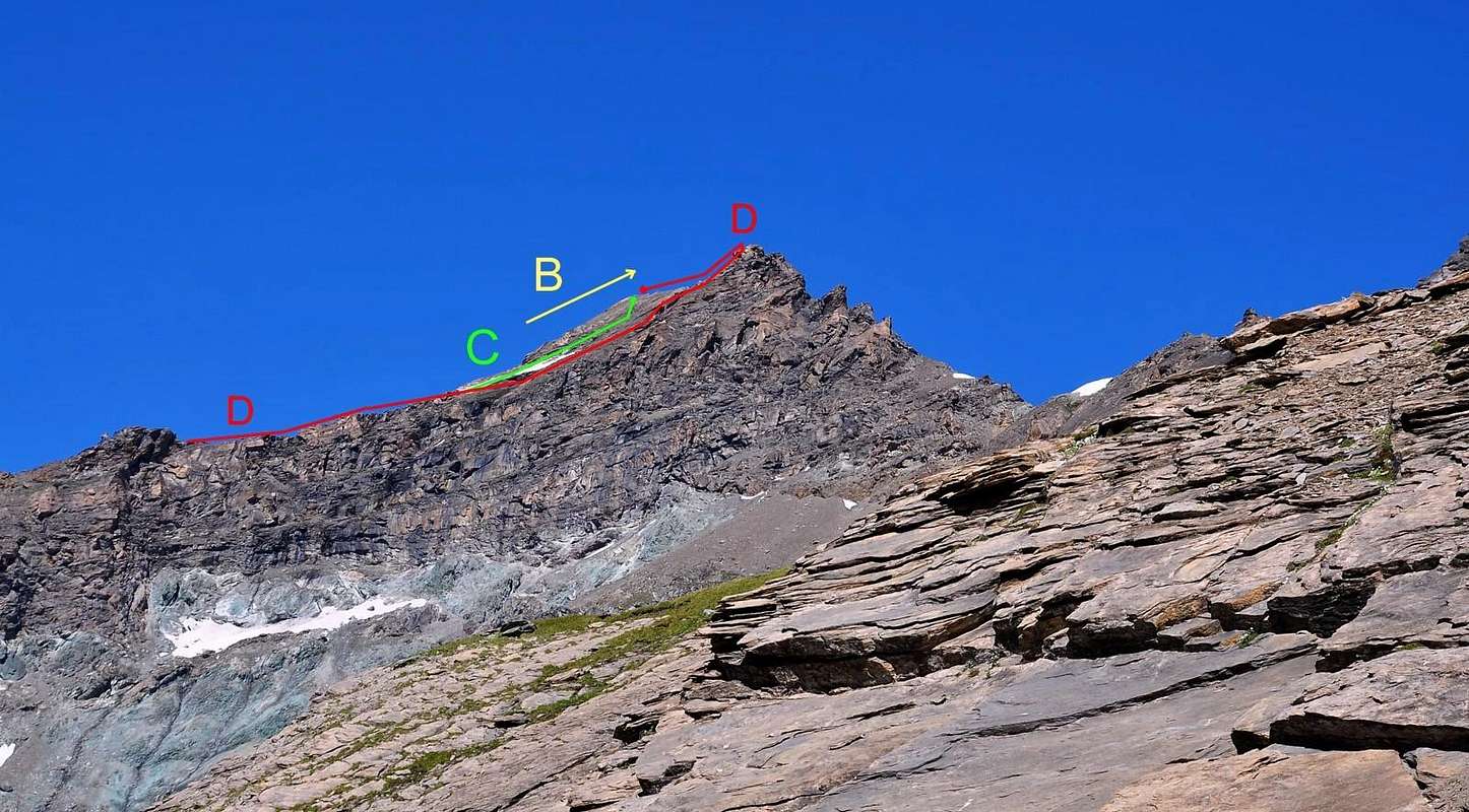
Route C) - Advised route for ascent with start from Filon Alp. From small fork 3.140/5m~ cross more in right (Eastnortheast) to a little debris and steep "hanging tableland" at base of an evident and long snowfield (wreckages of a Swiss Piper, white/blue navy coloured); directly also in right go up, by fragments and rocks, contra of SE Wall terminal part. To face up to deal with "delicacy" and, by progressive right/left ascent, through small rocks much friable and into earth fitted; taking advantage of a little ledge in the shape of letterbox briefly reach, by diagonal right/left, the Summit, hardly in right (PD-; I°/I°+, but very delicate and to Southeast exposed; 2h'30/3h'00 from pasture; same route advised as well in descent).
Via C) - Percorso consigliato per la salita partendo dall'Alpe del Filone. Dalla "forcella" 3.140/5 m~ portarsi più a destra (E-NE) in un piccolo plateau "sospeso", detritico e ripido alla base del caratteristico lungo nevaio (resti di un Piper svizzero di colore bianco/blu); risalirlo direttamente oppure sulla sua sinistra per blocchi e frantumi sin contro la parte terminale della Parete SE. Affrontarla con delicatezza e progressivamente da destra verso sinistra su roccette molto friabili ed incastrate nel terriccio; sfruttando una piccola cengia, a forma di buca da lettere, in breve raggiungere la Vetta appena sulla sua destra (PD-; I°/I°+, ma molto delicato ed esposto a SE; 2h'30/3h'00 dall'alpeggio; percorso consigliato anche in discesa).
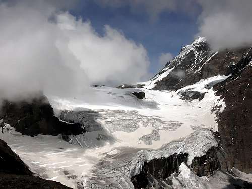
Route D) - From debris "hanging plateau" cross in right (East-northeast) at of small and long-narrow snowfield base moving to right (East) of steep slope border, where this fall through a vertical wall 560m high up Fenêtre Valley (see various pictures and in particular in Overview and above), just in right of a rocky head. Follow the S-SE Edge, in the shape of rocky scimitar, directly to East Ante-summit (3.295/3.000m~). Before by broken and rotten rocks, after with better quality, but more steep and round (II°/II°+, wanting and most in right even III°/III°+), climb in vertical line in case "leaning" in left and to reach; from this briefly and easily go down along SW tiny edge to large saddle 3.280/5m~, between East Ante-summit and Summit and always on frontier crest, aerial but easy, to reach (PD+/AD-; 2h'30/3h'00 from alp).
Via D) - Dal plateau detritico e "sospeso" attraversare verso E-NE alla base del piccolo e allungato nevaio portandosi all'estremità destra (E) del ripido pendio, ove questo cade a SE con una precipite parete di 560 metri sul Vallone di Fenêtre (vedi varie foto ed in particolare in quella d'"ouverture" e sopra), subito a N di una testa rocciosa. Seguire lo Spigolo S-SE che, in forma di scimitarra rocciosa, sale direttamente all'Anticima Est (3.295/3.000 m~). Dapprima su rocce rotte, poi con miglior qualità, ma più ripide ed arrotondate (II°/II°+, volendo e più a destra anche III°/III°+), arrampicare direttamente appoggiandosi eventualmente a sinistra raggiungendola; da questa scendere brevemente e facilmente lungo la crestina SW alla larga sella 3.285 m~, tra Anticima Est e la Vetta e sempre sulla cresta di frontiera, aerea ma facile, raggiungere la Vetta (PD+/AD-; 2h'30/3h'00 dall'alpeggio).
DESCENT: the frontier SW Ridge to Filon Pass (3.251m) advised or Route A.
DISCESA: si consiglia la cresta di frontiera SW verso il Colle del Filone (3.251 m) o Via A.
Difficulty
EE/A; F+/PD- or A; PD+/AD-, routes relatively (see in of various routes details).
EE/A; F+/PD- or A; PD+/AD-, relativamente alla via percorsa (vedi nel dettaglio analitico delle varie vie).
Gear
Hiking gear or for mountaineering by rope, same above remarks.
Da escursionismo o da alpinismo con corda con le stesse considerazioni di sopra.
Campings
Remember that free camping is forbidden (except for emergency reasons, over 2.500m, from darkness until dawn).
 |
 |
Mountain Conditions
- You can get meteo information at the official site of the Regione Valle d'Aosta:
- Valle d'Aosta Meteo
Webcam
- WEBCAM on Aosta Valley:
- Webcam
Books and Maps
BOOKS:
- "Guida dei Monti d'Italia-Alpi Pennine" (Vol. I°) di Gino Buscaini-Club Alpino Italiano/Turing Club Italiano, Luglio 1971 (in Italian).
- "Diari Alpinistici" di Osvaldo Cardellina e Indice Generale accompagnato da Schedario Relazioni Ascensioni 1964-2019 (inediti).
- "Guida della Valpelline" de l'Abbè Joseph-Marie Henry - Societè Editrice Valdotaine 1925 II Edition e Collana Reprint Musumeci (1986).
 |
 |
MAPS:
- Kompass "Massiccio del Monte Bianco Valle d'Aosta" Carta escursioni, bike e sci alpinismo 1:50.000.
- L'Escursionista "Valpelline, Saint Barthélemy" (carta n° 6) 1:25.000.
- C.N.S. "Mont Vèlan", foglio 1366, 1:25.000.
- Kompass "Breuil/Cervinia-Zermatt" Carta escursioni, bike e sci alpinismo 1:50.000.
- I.G.C. Istituto Geografico Centrale "La Valpelline, Ollomont, Saint Barthélemy", (carta n° 115) Map1:30.000.
 |
 |
 |
Important Information
- REGIONE AUTONOMA VALLE D'AOSTA the official site.
- FONDAZIONE MONTAGNA SICURA Villa Cameron, località Villard de la Palud n° 1 Courmayeur (AO) Tel: 39 0165 897602 - Fax: 39 0165 897647.
- SOCIETA' DELLE GUIDE DELLA VALPELLINE Etroubles-Strada Nazionale, n° 13 - Tel +39 0165 78559 - Valpelline-Loc Capoluogo, n° 1 - Tel +39 0165 713502 (AO) Italia.
- A.I.NE.VA. (Associazione Interregionale Neve e Valanghe).
Useful Numbers
- Protezione Civile Valdostana località Aeroporto n° 7/A Saint Christophe (Ao) Tel. 0165-238222.
- Bollettino Meteo (weather info) Tel. 0165-44113.
- Unità Operativa di Soccorso Sanitario Tel. 118.