
-
 12373 Hits
-
 80.49% Score
-
 12 Votes
|
|
Mountain/Rock |
|---|---|
|
|
45.94570°N / 7.47186°E |
|
|
Italy-Swiss border |
|
|
12185 ft / 3714 m |
|
|
Overview
Placed on the border between Swiss and Italy and rising above the glacier d'Otemma and the comba d'Oren. It's the higest and most important subgroup along the chain enclosed by Dent d'Herens and Grand Combin.
All the massif is mostly composed by gneiss rocks, not very good in the southern part. The ridge culminates with four peaks; the southern is considered as outstanding mountain and called Gran Becca di Blanchen. It's quite isolated and rarely clinbed for the pourpose of the singular peaks.
The massif from the refuge Nacamuli
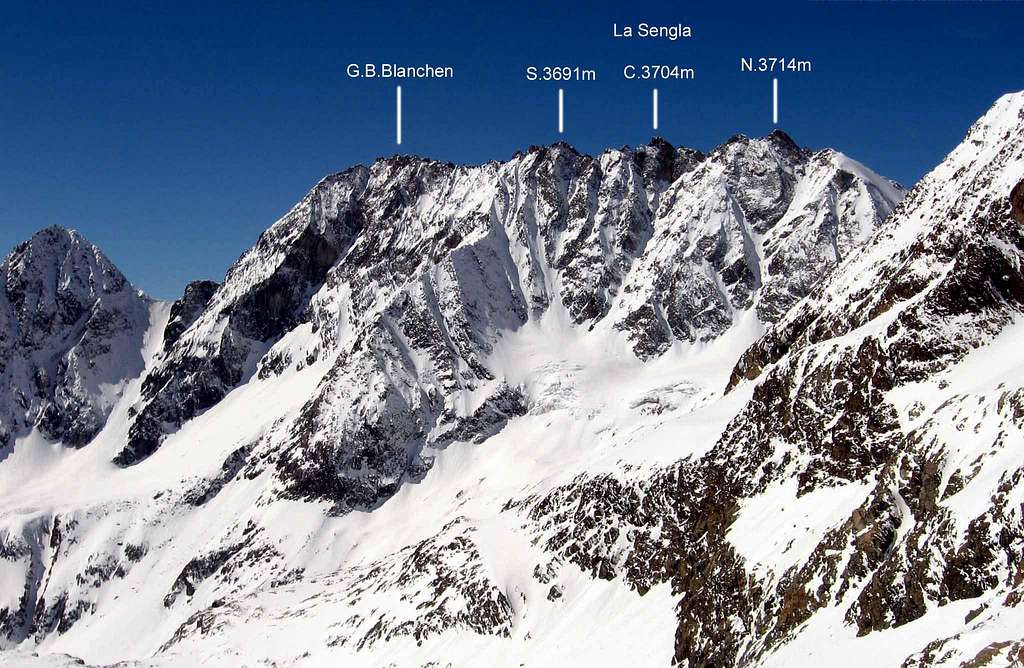
La Sengla (3.714m)
"La Sengla" is a name may be derived from latin or the local patois lenguage. The sense could be "La Sega" (the saw) or "La Cengia" (the ledge). It's an enormous rocky ridge long more or less 1 Km with a north-south direction. It's composed by 3 main peaks and many more pinnacles, that give it the shape of a saw (that gives the sense of the name). The massif start from Col d'Oren (3.262m), and it's delimitated by the huge Otemma glacier (Swiss side) on north, and the Blanchen glacier on west. The east side has a shape of a big rocky wall that rise above the Comba d'Oren. The most and typical route is the traverse of the 3 peaks for the entire length of the ridge. On the west side, a cozy shelter permits a shorten approach from swiss side. It's called "bivouac de la Sengla".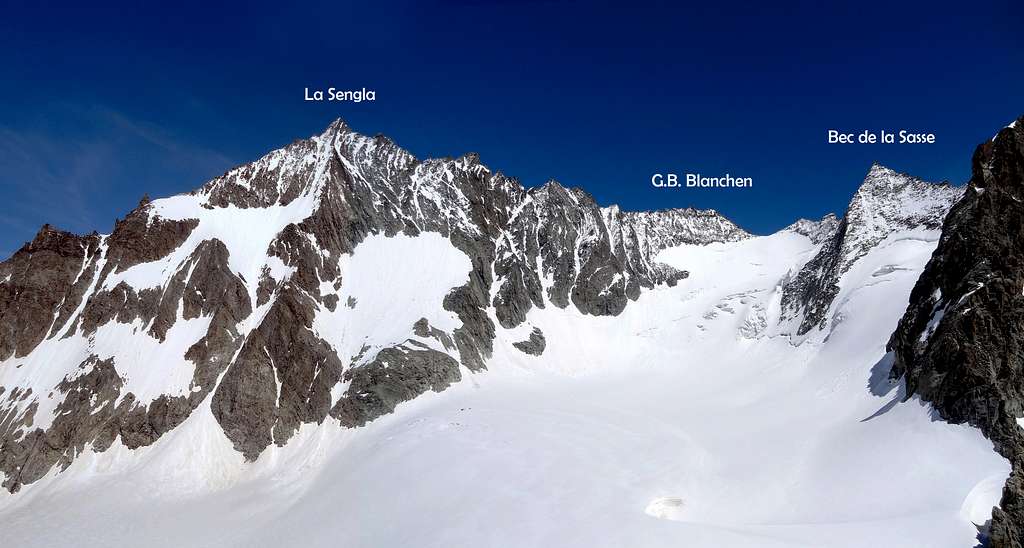
La Sengla from bivouac de la Sengla
Gran Becca Blanchen (3.680m)
"Gran Becca di Blanchen" is the fourth summit situated on the southern part of the massif. It's not the highest, but topografically very important; and signed on the maps as indipendent mountain. The name "Blanchen", derived from the local patois lenguage and it means "white firm ground". It's divides the major structure (La Sengla), in two ridges. One on the border extended to south-west with the groups "Tseuque-Rayette-Chardonney", and the other that separates Comba d'Oren from Comba de la Sasse. The summit is easily climbed from the Bivouac de la Sasse. Also for skimountaineering.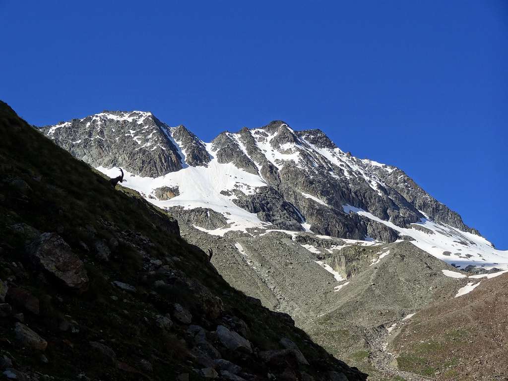
Gran Becca di Blanchen and locals ibex
Getting there
From Italy: Location Alta Valpelline. From Milan motorway A4 and from Turin motorway A5 to Aosta. Take the direction to Pass. Gran S.Bernardo, and turn right at the village of Valpelline direction Diga Place Moulin.From Swiss: Along the route from Martigny reach Sembrancher where a route follows the Val de Bagnes till Mauvoisin (1.840m) near a big dike. By a white narrow route (some danger, not always open) you can reach the Cabane Chanrion (2.460m) and Bivouac de la Sengla near the end of Otemma glacier.
Routes and history
LA SENGLA South summit (3.690m) - East spur - Ettore Canzio, Felice Mondini 18/08/1898 - South ridge - Alexander Jenkins 30/07/1913 - West flank - Alessio Alvazzi, Umberto Balestrieri 16/08/1919.Central summit (3.704m) - East flank - Maurice Gilbert 28/09/1924.
North summit (3.714m) - West flank - Carl Shroeder, Seraphine Bessard 22/07/1867 - North ridge - Alexander Jenkins 27/06/1911 - normal route for the main summit - East spur - Gino Costa, Bruno Martinazzi, Leopoldo Saletti 22/07/1922.
Traverse - Total length 2.000m from Col d'Oren and Col Blanchen. 30 pinnacles. Difficulties IV°/V° max. From 8 to 12 hours. Very long travesre and not often climbed GRAN BECCA BLANCHEN - Southwest ridge - Normal route. Nice and funny climb (PD/PD+) 2/3 hours from Biv. de la Sasse - North ridge - Stuart Jenkins, Jean Gaudin 30/07/1913 - Southeast ridge - Mario Santi, Pompeo Viglino 06/08/1917.
Refuges and Huts
Italian side: Ref. NACAMULI al COL COLLON (2.828m) 60 places. At the head of Comba d'Oren, 3-4 hours from the dike of Place Moulin. Open summer and spring for ski-mauntaineering. Difficulty E.Bivouac DE LA SASSE (2.973m) 12 places. At the head of Comba de la Sasse. 3 hours from Chamen. Open any time. Difficulty E.
Swiss side: Bivouac De LA SENGLA (3.199m) 12 places. Placed on the eagle nest called "l'Aiguillette" above the glacer Otemma. 2 hours from Cabane de Vignettes (F). 3 hours from Cabane du Charrion (F). 3 hours from Chamen across del Col d'Otemma (PD).
Mountain Conditions
- You can get meteo information at the official site of the Regione Valle d'Aosta:
- Valle d'Aosta Meteo
Webcam
- WEBCAM on Aosta Valley:
- Webcam
Books and Maps
BOOKS:
- "Guida delle Alpi Occidentali", di Giovanni Bobba e Luigi Vaccarone C.A.I. Sezione di Torino Volume II (parte II), 25 Maggio 1896.
- "Guida dei Monti d'Italia-Alpi Pennine" (Vol. I°) di Gino Buscaini-Club Alpino Italiano/Turing Club Italiano, Luglio 1971 (in Italian).
- "Diari Alpinistici" di Osvaldo Cardellina e Indice Generale accompagnato da Schedario Relazioni Ascensioni 1964-2019 (unpublished).
- "Guida della Valpelline" de l'Abbè Joseph-Marie Henry - Societè Editrice Valdotaine 1925 II Edition e Collana Reprint Musumeci (1986).
- "Rifugi e bivacchi in Valle d'Aosta" di Cosimo Zappelli aggiornata da Pietro Giglio. Musumeci Editore, Luglio 2002 (in Italian).
 |
 |
 |
MAPS:
- Kompas "Breuil Cervinia Zermatt" Sentieri e Rifugi Carta turistica 1:50.000.
- L'Escursionista "Valpelline, Saint Barthélemy" (carta n° 6) 1:25.000.
- I.G.C. Istituto Geografico Centrale "La Valpelline, Ollomont, Saint Barthélemy", (carta n° 115) Map1:30.000.
- Carta Nazionale Svizzera "Foglio Valpelline" 1:50.000.
Important Information
- REGIONE AUTONOMA VALLE D'AOSTA the official site.
- FONDAZIONE MONTAGNA SICURA Villa Cameron, località Villard de la Palud n° 1 Courmayeur (AO) Tel: 39 0165 897602 - Fax: 39 0165 897647.
- SOCIETA' DELLE GUIDE DELLA VALPELLINE Etroubles-Strada Nazionale, n° 13 - Tel +39 0165 78559 - Valpelline-Loc Capoluogo, n° 1 - Tel +39 0165 713502 (AO) Italia.
- A.I.NE.VA. (Associazione Interregionale Neve e Valanghe).
Useful numbers
- Protezione Civile Valdostana località Aeroporto n° 7/A Saint Christophe (Ao) Tel. 0165-238222.
- Bollettino Meteo (weather info) Tel. 0165-44113.
- Unità Operativa di Soccorso Sanitario Tel. 118.