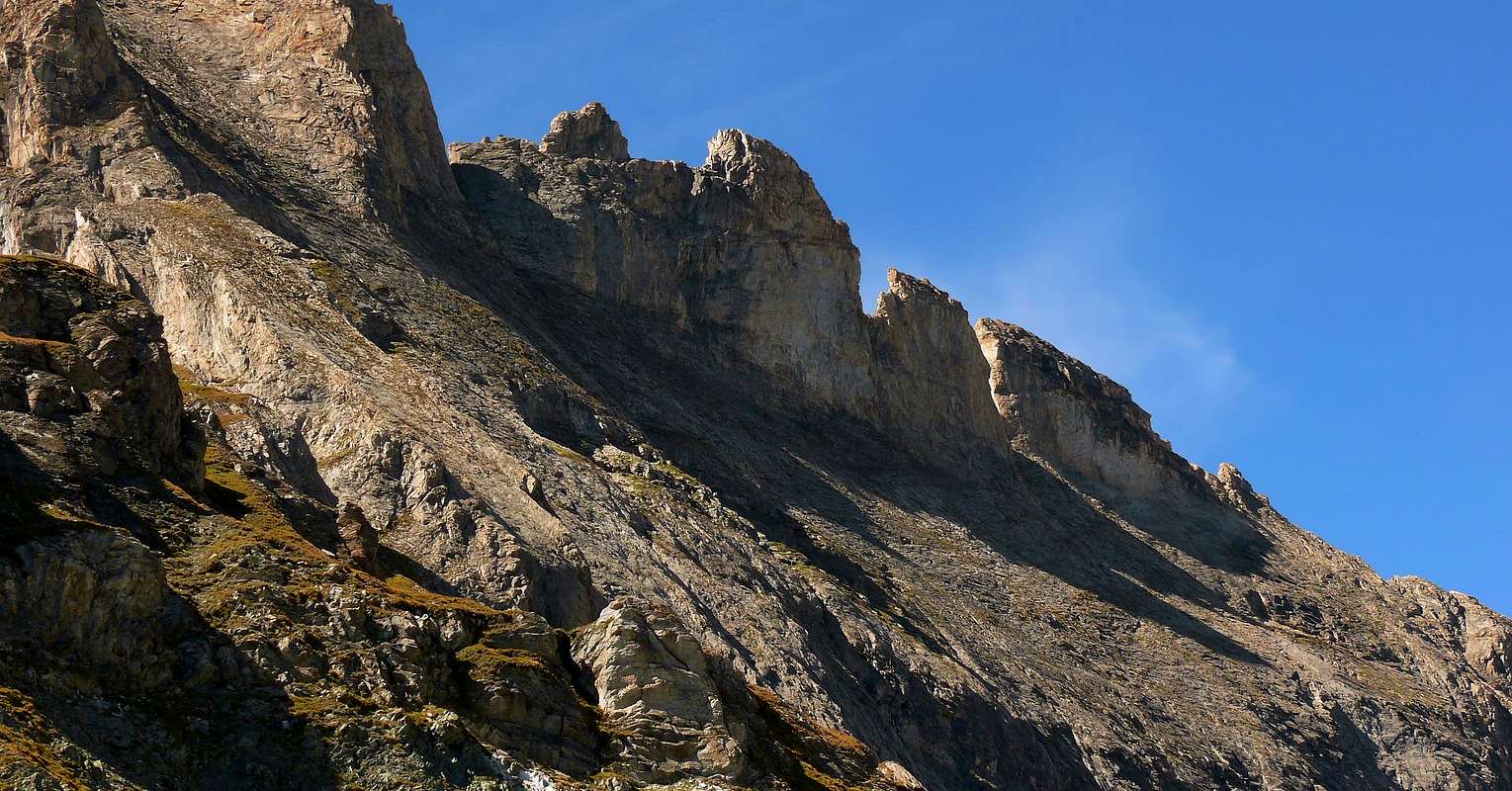
By Three Brothers Valsorey the ridge of the border between Italy/Switzerland becomes somewhat jagged going to form the top five in succession, called molars Valsorey. The first four, or more Westerners, have a complex and difficult climb in search of the street, while the last one shows easily accessible along its crest Eastern, after the ascent on South Slope to a easily carving. We therefore propose the ascent of the same, known as the fifth Molar Valsorey, recalling that the departure from the bivouac should perform it Rosazza-Savoie, although it is possible to reach the base directly from the South, starting from the most Eastern By Basin of the private dirt farms road through the Alps By Seitives and Vescovi 2.065-94m, 2.038m). The ascent is not difficult, but very exposed to the North, as incidentally for all five Molars. Great views of the nearby giants of the Grand Combin and Mont Velan which rise respectively to the west and the front; beautiful shots of an eye the entire Basin By.
Dai Tre Fratelli di Valsorey la cresta di confine Italo/Svizzera diventa alquanto frastagliata andando a formare in successione cinque sommità, chiamate Molari di Valsorey. Le prime quattro, o più Occidentali, presentano una salita difficile e complessa nella ricerca della via, mentre l'ultima si presenta facilmente accessibile percorrendo la sua Cresta Orientale, dopo aver raggiunto da Sud una facile breccia. Proponiamo quindi la salita della medesima, conosciuta come V° Molare di Valsorey, ricordando che la partenza conviene effettuarla dal Bivacco Rosazza-Savoie, anche se é possibile raggiungerne la base direttamente da Sud partendo più ad Oriente dalla strada poderale della Conca di By attraverso le Alpi Seitives ed i Vescovi 2.065-94 m, 2.038 m). Ascensione non difficile, ma molto esposta a Settentrione, come daltronde per tutti e cinque i Molari. Grandi vedute sui vicini colossi del Mont Velan e del Grand Combin che si elevano rispettivamente ad Ovest e frontalmente; splendide viste sull'intera Conca di By.
First Ascents
First on the summit: Paolo Ferrario and Carlo Semenza, Summer 1913.
In winter: Unknown.
N-NE Crest: Paolo Ferrario and Carlo Semenza, Summer 1913, in ascent.
E Face: Paolo Ferrario and Carlo Semenza, Summer 1913, in descent.
Entire Traverse on Five Molars from East to West: Ettore Castiglioni and Degli Uomini, Aug 31th, 1943. Second Crossing: Matteo Armani and companions, after few days in the same summer.
Getting There
BY CAR:
From Torino, Milano, etc: Motorway A5. Exit at Aosta Est.
From Switzerland: through the Grand Saint Bernard Tunnel or the namesake pass.
From France: through the Mont Blanc Tunnel or Petit Saint Bernard Pass. It is not necessary to take Motorway A5: you can drive on SS.26, in the direction of Aosta.
BY PLANE:
Aeroporto "Corrado Gex" Saint Christophe (Aosta).
Itinerary
From Aosta East exit of the motorway, follow along the SS.27 for the Gran San Bernardo Tunnel After about ten Km turn to the right toward Valpelline (964m), cross it and turn to the left to get Ollomont (1.335m) and the small built area of Glacier (1.549m), where you must start walking.
Dall'uscita del Casello Autostradale di Aosta Est, proseguire sulla SS.27 in direzione del tunnel del Gran San Bernardo; dopo circa un decina di chilometri svoltare sulla destra verso il Paese di Valpelline (964 m). Dopo averlo superato svoltare sulla sinistra e raggiungere il Paese di Ollomont (1.335 m); proseguire sino alla Frazione di Glacier (1.549 m), dove inizia l'itinerario a piedi.
Approach
From as soon as before the Village of Glacier (1.549m) to take the path n° 3/4/5 that verse is addressed reaching the Alpe Of it Pont (1.690m), it overcomes the Stream of By and it reaches the following of Crottes Pastures (1.733m); progressively becoming steep reaches the Alp Cheval Blanc (1.962m) and the neighbor "Lake Farinet's" (1.987m). From this point, left on the right the paths n° 4/5, to continue by direction West-southwest crossing the emissary of the small lake and reaching the earth road "poderale" to the tornante (= hairpin bend; 2.025m); leaving on the right the continuation in direction of the Les Eveques Alp (2.038m) shortly and along to reach that some Alp Porchère (2.094m) and, through direction North, that that is than above or Tsa de Porchère (Tsa = Higher Pasture, generally the last; 2.290m; spring water). From this, proceeding through a long diagonal to North-northwest, to reach an alternative to quota 2.400m around, from where two possibilities of continuation of the route they are verified:
a) - to directly continue on the path of right (East) reaching the thread of crest of the Dos de Boégno Bà (= Rise of the Down Ear)and to actually follow it to the Quota 2.507m, old which folding up to the left slightly and with a steep final line to reach the Bivouac out Rosazza to the Savoie (2.651m; 3h'00).
b) - from the alternative 2.400 meters around to take the ramification of left (West) that it is addressed toward the Alpe Plan Bagò (2.436m) but not to reach her; to a further intersection in quota as the precedent to climb by a parallel path always initialed n° 3 and coming from the Alp Chesal (2.039m); to go up again at first it toward North, after through a short diagonal to NW to reach the Torrent of Plan Bagò, near a characteristic great boulder. To get further on the right and, by a last upsurge, to reach from left toward right the Bivouac out Rosazza at the Savoie (2.651m; 3h'00).
Da appena prima del Villaggio di Glacier (1.549 m) prendere il sentiero n° 3/4/5, che si indirizza verso NE raggiungendo l'Alpe Pont (1.690 m), supera il Torrente di By e raggiunge i successivi Alpeggi di Crottes (1.733 m); diventando progressivamente più ripido raggiunge l'Alpe Cheval Blanc (1.962 m) ed il vicino "Lago Farinet" (1.987 m). Da questo punto, lasciati sulla destra i sentieri n° 4/5, continuare con direzione W-SW attraversando l'emissario del piccolo lago e raggiungendo la strada poderale al tornante 2.025 m; lasciando sulla destra la continuazione in direzione dell'Alpe Les Eveques (2.038 m), brevemente e lungo la medesima raggiungere quello dell'Alpe Porchère (2.094 m) e, tramite direzione N, quella che sta di sopra o Tsa de Porchère (2.290 m; sorgente). Da questa procedendo con un lungo diagonale a N-NW raggiungere un bivio a quota 2.400 m circa, donde si verificano due possibilità di continuazione del percorso:
a) - proseguire direttamente sul sentiero di destra (E) raggiungendo il filo di cresta del Dos de Boégno Bà (= Dosso dell'Orecchia Abbassata) e seguirlo sino alla Quota 2.507 m, superata la quale piegando leggermente a sinistra e con un tratto finale più ripido arrivare al Bivacco Rosazza al Savoie (2.651 m3h'00).
b) - dal bivio 2.400 m circa prendere la ramificazione di sinistra (O) che si indirizza verso l'Alpe Plan Bagò (2.436 m) ma non raggiungerla; ad un ulteriore incrocio in quota come il precedente salire con un sentiero parallelo sempre siglato n° 3 e proveniente dall'Alpe Chesal (2.039 m); risalirlo dapprima verso N, poi con un corto diagonale a NW raggiungere il Torrente di Plan Bagò presso un caratteristico grande masso. Allontanarsi sulla destra e, con un ultima impennata, raggiungere da sinistra verso destra il Bivacco Rosazza al Savoie (2.651 m; 3h'00).
Route
From the Bivacco out Rosazza/Savoye and from the neighbor of Boegno Bas Pass (2.674m) to address him toward Northeast along a trace that with a long diagonal in light, overcoming some small valleys in grass, it brings him in direction of the unnamed lake (quota 2.688m GPS); not to reach it, on the contrary to go up again the rather steep moraine or the snowfields reaching the Southern Glacier of Valsorey. To always go up again it with greater inclination crossing it at the base of the long crest that the Three Brothers of Valsorey unite to the Five Molars and do what it is above doubling on the left (North) the rocky quota 2.931m; here the inclination goes decreasing and the run is mostly turned toward rising; as soon as possible to reverse the direction of travel and, through a ledge of rocks and debris very broken (in early season snow) that rises diagonally from right to left, reaching the crest rather broad and straight. Follow the same to the west and bypassing some short distance to the south, easily reach the Top. (3.230m) 2h'15/2h'30.
Dal Bivacco Rosazza/Savoye e dal vicino Col du Boegno Bas (2.674 m) indirizzarsi verso NE lungo una traccia che con un lungo diagonale in leggera, superando alcune piccole valli in erba, si porta in direzione del lago innominato (quota 2.688 m GPS); non raggiungerlo, bensì risalire la ripida morena oppure i nevai soprastanti raggiungendo il Ghiacciaio Meridionale di Valsorey. Risalirlo con pendenza sempre maggiore percorrendolo alla base della lunga cresta che unisce i Tre Fratelli di Valsorey ai Cinque Molari e doppiando sulla sinistra (N) la quota rocciosa 2.931 m; qui la pendenza va diminuendo ed il percorso è rivolto maggiormente verso levante; appena possibile invertire la direzione di marcia e, tramite una cengia di rocce molto rotte e detritici (in inizio stagione nevai) che sale in diagonale da destra verso sinistra, raggiungere la cresta spartiacque piuttosto larga e rettilinea. Seguire la medesima verso Ovest e, aggirando qualche breve tratto a Sud, facilmente raggiungere la Cima (3.230 m)2h'15/2h'30.
Difficulty
This route can be considered PD/PD+.
L'itinerario è classificato PD/PD+.
Equipment
Standard mountaineering equipment.
Da alpinismo.
Huts
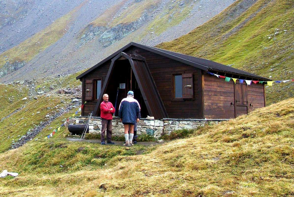
Bivacco ROSAZZA-SAVOIE
Campings
Remember that free camping is forbidden (except for emergency reasons, over 2.500m, from darkness until dawn).
Mountain Conditions
You can get meteo information at the official site of the Regione Valle d'Aosta:
Parents refers to a larger category under which an object falls. For example, theAconcagua mountain page has the 'Aconcagua Group' and the 'Seven Summits' asparents and is a parent itself to many routes, photos, and Trip Reports.

 5859 Hits
 87.31% Score
 24 Votes