
-
 7969 Hits
-
 73.06% Score
-
 3 Votes
|
|
Mountain/Rock |
|---|---|
|
|
58.42728°N / 134.35669°W |
|
|
Hiking, Mountaineering, Scrambling |
|
|
Summer, Fall |
|
|
5587 ft / 1703 m |
|
|
Overview
Nugget Mountain is a challenging and rewarding climb. This mountain has a bit of it all. Steep lose rock, ice, and scrambling. The slopes near the summit are steep and bare, and heavy avalanche danger can persist on the mountain well into spring. Doing this mountain in mid to late summer is my best recommendation.
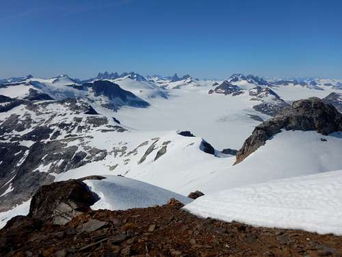
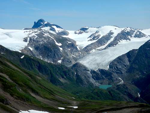
Nugget provides a stunning view of the Juneau Icefield and a dramatic transition into the glaciated alpine environment from the coastal forests of lower elevation. Lemmon and Ptarmigan glacier as well as the valley lakes are visible as well as Split Thumb, Amherst, Spencer, and the Mendenhall Towers.
Getting There
The hike starts from the same location as the well-known hike to Thunder Mountain.
The trailhead begins at the end of Jennifer Drive behind Glacier Valley Elementary School. Follow boardwalk over swampy terrain until it intersects a dirt trail. Take a right here and the Thunder Mountain trail turns left and up just after a small stream. This trail climbs very steeply in the beginning.
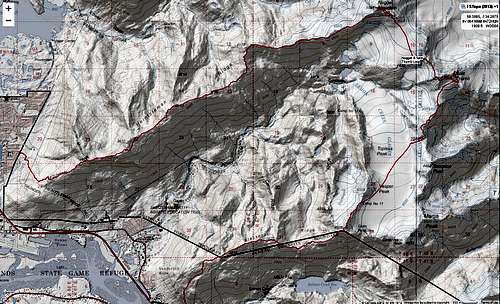
Another option is to climb from Blackerby Ridge and go via Camp 17. Its a longer route and involves traversing the Lemmon Glacier. I have included the route in the map and as part of the .gpx file located on the Nugget Mountain Standard Route page.
Route
The Nugget Mountin Standard Route starts from the well known Thunder Mountain Trail. Follow the trail for 2.3 miles to the top of the Thunder Mountain Ridge. From here follow the user trail on climbers right and follor the ridge for 8 miles. From there, steeply downclimb on climbers right onto the snow and traverse below the summit to the opposing ridge to avoid cliffs. On the opposite ridge, hight straight towards the summit and at 11.35 miles you're there!
See the route page for more details and for the map and Garmin .gpx files.
Red Tape
There is no red tape here, so please use LNT principles.
When to Climb
Mid to Late summer when the most rock is exposed is probably the best time of year. Early Spring ascents would be reasonable as well, though there will be avalanche danger on the highest slopes.
June can be a really nice time to climb since it’s the sunniest summer month, though there tends to be more snow around. This might be a miserable and dangerous slog this time of year with wet slides and soft snow.
Camping
Backcountry Camping
Permits are not needed to camp in the Tongass National Forest. Camping Spots can be found on the ridges in the alpine areas.