
-
 83283 Hits
-
 94.4% Score
-
 47 Votes
|
|
Mountain/Rock |
|---|---|
|
|
39.76000°N / 106.34°W |
|
|
Summit |
|
|
13580 ft / 4139 m |
|
|
Under New Management
Hi everyone, the previous owner of this page has decided to move on from Summitpost and is in the process of transferring pages to new owners. As such, I have agreed to adopt this page.
I took over on March 7, 2012, along with several other pages. This page is completely new and reformatted. I hope you find the new pages as informative and useful as the old ones, please feel free to leave any comments you have. If anyone wants to submit the standard south slopes route, please do!
Happy hiking!
"Chicago Transplant"
Overview
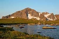
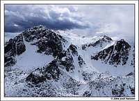
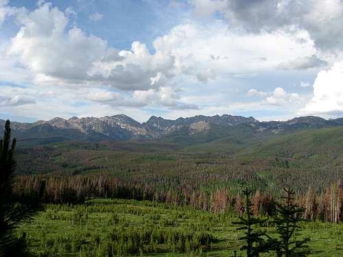
Mount Powell is the highest peak in Gore Range of Colorado, a rugged range that runs along the Eagle and Summit county border north of Vail, Colorado. This rugged range is home to some of the best ridge scrambling in Colorado, but due to the lower elevations of the peaks, goes largely unclimbed. The Gore Range does not contain any of the states famed fourteen thousand foot peaks, nor do any of the highest 100 peaks reside here. Mount Powell just grazes the end of the highest 200 list, but it depends on how one determines its summit elevation. Powell is also the highest peak in Eagles Nest Wilderness.
The summit of Mount Powell has no survey benchmark, just a closed 13,560' contour. The elevation could be as low as 13,561', or as high as 13,599', as such the accepted practice in Colorado is generally to "split the difference" between the last closed contour and what the next contour would be. In the case of Mount Powell, that leads to an interpolated elevation of 13,580'. With this elevation, Mount Powell has 3000' of prominence and is the most prominent peak in Summit County. The Eagle/Summit County line passes just to the southwest of the summit through a false summit, as such the summit area resides entirely within Summit County.
Mount Powell is named for Major John Wesley Powell, leader of the famed 1869 Powell Geographic Expedition, which included the first known passage through the Grand Canyon. Powell was also the director of the US Geological Survey from 1881-1894. Lake Powell is southern Utah is also named for him.
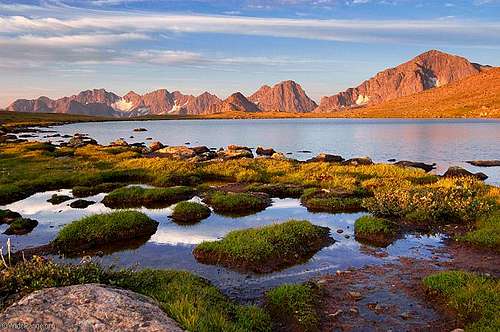
Mount Powell is visible from Colorado State Route 9 when traveling between Kremmling and Silverthorne, sometimes on this drive Peak O is mistaken for Powell, earning it the nickname "Little Powell". There are great views of Mount Powell and the northern Gore Range from Ute Pass to the east of CO 9. From the west side, the best views of Powell are from either Piney Lake, or Vail's ski slopes.
The Gore Range
The Gore Range is a diverse range that can be broken up into three parts, the northern range runs generally from Rabbit Ears Pass south to the Colorado River. This section is generally below 11,000', and has many gentle treed summits. The Central Gore Range is generally what people refer to when they refer to the range, and contains all of the high rugged peaks of Eagles Nest Wilderness. The southern range runs from I-70 at Vail Pass to just north of Leadville and is generally a high rolling ridge. The southern section includes Vail ski area, Ski Cooper and Camp Hale - site of the 10th Mountain Division training camp during WWII.
The Central Gore Range is a series of ridges radiating from a central spine that roughly follows the Eagle/Summit county border. In general, the peaks on the Summit County side are the tallest, the range crest generally low 13ers, and the Eagle County side peaks are primarily 12ers. There are very few officially named peaks in the range, of which Mount Powell is one. Many of the peaks are named for the alphabet, Mount Powell would be "Peak B" if following the alphabet names. Many of the summits in the range fall below the 300' prominence criteria generally used in Colorado to call a summit a separate peak, but the sub-summits of the Gore are some of the most rugged and complicated peaks of this range.
Combining peaks on ridge traverses can get complex and technical in nature. Many of the ridge traverses require a minimum of class 4 scrambling on exposed ledges and gendarmes. The traverse from Powell to Eagles Nest is one such traverse. I have done the traverse from Eagles Nest to Powell, and can attest to its difficult and sustained scrambling. Do not attempt without stellar weather as bailing out can be difficult, and you don't want to be stuck up there in a storm!
Traditionally Gore Range enthusiasts have been rather protective of the treasures that lie within this range, and for good reason. Some of the best scrambling in Colorado is found here. The peaks have seen more traffic in recent years, but in all the ascents I have done, I have only once shared a summit with someone not in my climbing party. It can be difficult to find information on the peaks in this range, but that is not just a product of protective behavior. The Gore is one of the best places in Colorado to be able to explore without trails, cairns or step by step photographs. To me, this lack of detailed information is a "plus", and I will intentionally provide information only in general terms on this peak, and other Gore pages I have put up. Even the information I have provided is probably "too much" for some, but hopefully it strikes a good balance between giving you enough information to have a safe adventure, without giving too many secrets away. I hope you enjoy your time exploring my favorite mountains... this sense of adventure is part of what makes these peaks so special.
Getting There
The primary access point for Mount Powell and the surrounding summits is through the town of Vail. Exit I-70 at Exit 176 (Vail) and head west on the North Frontage Road for 1 mile to Red Sandstone Road, turn right and follow the paved road for 3/4 miles. The paved road switches to the right and a graded dirt/gravel road (FS 700) continues on from this point (signed). If muddy, 4WD is recommended, but the road is usually fine for 2WD vehicles, but gets a little rutted towards the end. Follow the road for 11 miles to the parking area just before the entrance to Piney River Ranch. The ranch is private, however, there is a public trail that starts across the road and skirts the ranch to provide access to Eagles Nest Wilderness and Mount Powell. There is some dispersed camping along the road. In winter the road is closed about 1/2 mile up the dirt road, typically opening around Memorial Day.
Alternate access from the Summit County side is rough and remote with limited trail access and a lot of rough bushwhacking. To start this journey, the Brush Creek Trailhead would work best, its a tough single lane 4WD jeep road, directions are described here on Kane's Peak N page.

Route Information
Mount Powell is relatively easy to climb by Gore Range standards, but don't let that fool you - all peaks in this range require long approaches, off trail hiking, good route finding skills, plenty of vertical feet, and some degree of boulder hopping or scrambling to reach their summits. There are no "gimme" summits in the Gore!
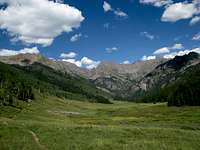
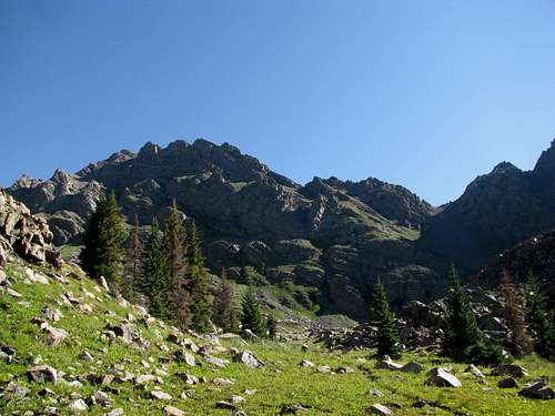
The easiest route on Mount Powell is the southeast slopes route, the normal approach is via the unmarked Kneeknocker Pass Trail. This trail is really a spur of the Upper Piney River Trail that also provides access to several other peaks in the area, including those of the Ripsaw Ridge. The initial approach on the upper Piney River Trail is fairly straight forward on a well maintained trail that generally stays about 200 feet or so above the river once past the ranch. You will follow it for about 3 miles, the last mile of which gets a little steeper before dropping slightly toward the Piney River. The trail split is usually marked with a small cairn, and is just after the main trail begins to parallel the Piney River.
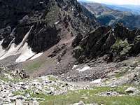
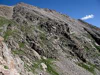
This trail can be tough to follow, especially in a lower meadow that is quite overgrown, the trick is to know that after the meadow the trail parallel's the steep cascading creek on its left (west) side. I think I have lost it every time I have passed through that meadow, but have always picked it back up again as it goes back in the woods near the creek. Its easier to follow beyond this point, but if you lose it, just stay close to the creek and you will find your way to the upper basin. The trail gets really steep along the creek in a few places, but mellows once it reaches treeline. It then steepens again as it works through scree and talus to Kneeknocker Pass, which is the effective end of the trail. Snow and a cornice can choke the north side of the pass well into summer, some heavy snow years it never fully melts out. Negotiating this snow can be the route's crux.
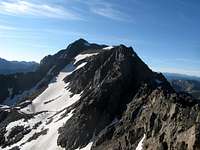
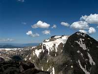
Once through the pass, bypass the lower rock bands of Powell's south ridge and ascend steep talus to a relatively flat area between Powell's true summit (right) and the false one that marks the county line. Reverse the route to descend. The photos below show a good overview of the general route from Kneeknocker to the summit.
Alternate routes include the East Couloir, or you can avoid Kneeknocker Pass by climbing on the west side of the south ridge. This second option gets complicated the higher up you get and ends in either one of several loose scree gullies, or by some class 3 scrambling to cross the south ridge. Good route finding skills are necessary to climb this route, but early season when Kneeknocker Pass is choked with snow, it may be the safest option.
In the spirit of adventure, I have intentionally left the routes beyond the approach trails in general terms, take the time to explore this area for yourself and the rewarding adventure you have will be one you will never forget, and something difficult to replicate on the states more popular higher peaks.
Red Tape
Mount Powell resides in Eagles Nest Wilderness of the White River National Forest, and is subject to the regulations of that area including no motorized or mechanized travel, leash regulations for dogs, and restrictions on camping locations, group size, feed for pack animals, and storage of materials. Read more about the requirements at the US Forest Service home page here.
The southwest side is in the Eagle Ranger District, with offices on US 24 just south of the Minturn exit (970) 827-5715. The northeast side is part of the Dillon Ranger District, with offices in Silverthorne just north of the outlet malls on the east side of Colorado 9 (970) 468-5400.
The area around Piney Lake is privately owned by Piney River Ranch. A public parking area lies just below the ranch entrance, and a public trail goes around the ranch. Please refrain from hiking through the ranch unless you are a guest there.
When To Climb
Typically the road to Piney Lake is closed to vehicles from early November to around Memorial Day, you would need a snowmobile or a bike during that time to get to the trailhead at the ranch, but would have to leave them there as the peak is in a Wilderness area. The cornice that forms in Kneeknocker Pass can be a beast through early summer, and in some heavy snow years, all year! It is best to climb this peak in late summer early fall to avoid it. Winter would be a long approach with avalanche prone slopes in the high basin and especially Kneeknocker Pass. As with all high peaks in Colorado, afternoon thunderstorms are a major threat, it is best to be off summits by no later than noon, but that is really just a guideline - be aware of storms moving in and give yourself plenty of time to get back to safety if you see the threat of severe weather moving in, things can change fast up there.
There is good fall color along the Piney River in fall, so perhaps mid-September is the best time for weather, Kneeknocker Pass conditions, and fall color.
Weather and Avalanche Forecasting: Below are some links to help you plan you trip.
Weather Link
Avalanche Forecast Link
Camping
There are several small dispersed camp sites along the Red Sandstone Road and some of the side roads off of it. A few of these have recently been closed for restoration, please observe all closures. There is also about a one mile stretch of the road that goes through private property, please do not camp in that area.
The peak lies within Eagles Nest Wilderness and backcountry camping opportunities are plentiful, just be sure to follow Leave No Trace and the Wilderness Area regulations for camping off trail, away from lakes and streams, and not within 1/4 mile of treeline. Campfires are allowed, but subject to Wilderness regulations and possible restriction during high fire danger. Also please refrain from camping until you are past the Piney River Ranch and within the wilderness boundary. You probably don't want to camp that close to the ranch anyway.
Wildlife
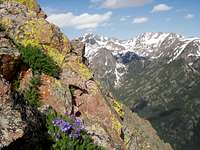
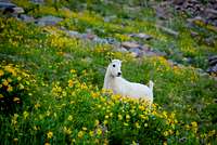
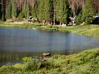
Piney River often has moose, I have seen them twice along the river, and almost walked into a third one in the dark from less than 10' away right by the ranch. We were lucky it wasn't as spooked by us as we were by it, maybe it saw our headlamps coming. Frequently turn your gaze to the river valley while along the approach and you may be lucky enough to catch a glimpse! Also watch for elk and deer on the Red Sandstone Road, I have almost hit one in the dark before. Of course large game aren't the only residents here, mountain goats, marmots, pikas, and various birds abound, so be on the look out and you might get a glimpse!
Acknowledgements
This page was originally composed and contributed by Aaron Johnson. Additional text and information was supplied by SP member jimmyjay, who also provided a link to this photo of John Wesley Powell: Powell.
Statistical information is from the website Lists of John. Information on John Wesley Powell is available here.
Also, thanks to all of YOU for your great photographs, routes, and trip reports! Keep them coming!
Scott - Mar 18, 2006 11:20 pm - Voted 10/10
Central GoresMighty Mount Powell stands at the north end of the Gore Range in north central Colorado. Hi Aaron. The only thing I might change about the page is the statement above. Powell is actually more southern than northern Gore Range, but could be considered to be part of the Central or "south-central" section of the Gore Range. The Gore Range actually extends all the way to Rabbit Ears Pass, just SE of Steamboat Springs, and way north of Powell. The mid-point is approximately at the Colorado River, putting Powell, way to the south of the center of the Gore Range. Perhaps it could be said that Powell: "Mighty Mount Powell stands at the north end of the Eagles Nest Wilderness in north central Colorado" instead of north end of the Gore Range.
Aaron Johnson - Mar 19, 2006 12:47 am - Hasn't voted
Re: Central GoresHi Scott. I see the basis of your point by looking at the TOPO map of the area. They do call it the Gore Range north of the river and Gore Pass is also there. But why would they do this? A river passing through a range does not a range make. At least, that is my logic behind it. And does this mean that the Mount Zirkel Wilderness is also the Gore Range simply because the range extends on into Wyoming? No. On the map, it's the Sierra Madre (a California name, of all things). Why the change in the name of the same range? Now then, tiny Tenmile Creek (not a river), passes through the range, which for all intents and purposes, is a continuation of the Gores. Only on the south side of the creek, the range is suddenly no longer the Gores. It's the Tenmile Range! The Gores do extend further south via Vail Pass, though, so I can buy that. Those mountains, such as Shrine and Copper, are part of the Gores. My point: Because a map states something does not make it so. For most, ranges, by definition, start or begin from a low point, or for higher designations, from a pass. A stream, or a river, of all things, passing completely through a range would certainly indicate a low and appropriate dividing spot for me. I submit back to you that even though the map says Gore Range north of the Colorado, it's technically not a range because of the presence of Gore Pass and a full fledged river. A third criteria I like to apply to Colorado's ranges is terrain above timberline. This is a strong indicator of whether a range is indeed a range. With this application, Powell is located at the north end of the range, with much wooded land intervening before we have another uplift above timberline in the Zirkels and the Sierra Madre. Now of course, there are many exceptions. By this application, the San Miguels are their own range, but they are regarded by most folks as part of the San Juans. For the sake of argument, let's say the San Miguels are their own range. But then we have a problem. Little Lone Cone cannot be its own range! However, the La Platas are certainly their own range like the Zirkels, with similar conditions between them and the San Juans. Yet they are considered by most, including the TOPO, to be a separate range. So because of a RIVER (which begins elsewhere and passes through the Gore range), I hold to my stance that the north end of the Gores is Eagles Nest and Powell. To suggest otherwise would, in my opinion, suggest the Zirkel area is not its own range (which I would not want because to me, it would diminish the importance of that range's status). Check out the thread I raised to the top of the Colorado forum. We had a great discussion about this, and primarily, how to deal with the mess that is the San Juans. I think you'd enjoy it if you haven't seen it already. I look forward to your reply. It's fun discussing this stuff.
Scott - Mar 20, 2006 1:10 am - Voted 10/10
Re: Central GoresI see the basis of your point by looking at the TOPO map of the area. Aha. It more than just the topo map. Keep in mind the namesake peak in the range, Gore Mountain is located well to the north of the Colorado (the mountain was named after a hunter). See below. Gore Pass is also well north of the river. Map-Gore Mountain-namesake of the Gore Range They do call it the Gore Range north of the river and Gore Pass is also there. But why would they do this? A river passing through a range does not a range make. At least, that is my logic behind it. I don't know why they (USGS) chose the boundaries where they did. The river would make a logical boundary for a different range, in my opinion. Rivers do in fact cut through many ranges, though. Some good examples are the Himalayas and Wasatch Range, both of which are cut by rivers. The Himalayas don't form a continental divide, thus all rivers in south Tibet actually cut through the Himalayas. The Wasatch are cut by rivers from the Uinta Mountians. This is because the Uintas are older than the Wasatch, and those rivers existed before the Wasatch did. The Cascade Mountains are also cut all the way through by rivers, including the Grandaddy of all rivers in the west, the Columbia. And does this mean that the Mount Zirkel Wilderness is also the Gore Range simply because the range extends on into Wyoming?No. On the map, it's the Sierra Madre (a California name, of all things). Why the change in the name of the same range? Actually, Mount Zirkel is in the Park Range. Sierra Madre is NW of Zirkel area. My point: Because a map states something does not make it so. For most, ranges, by definition, start or begin from a low point, or for higher designations, from a pass. Good point, but if this is the case, the namesake mountain of the range (Gore Mountain) is actually north of the Colorado River, so that is the "real Gore Range". We should call the range to the south "Eagles Nest Range" or divide them into "Northern Gore Range" and "Southern Gore Range" A stream, or a river, of all things, passing completely through a range would certainly indicate a low and appropriate dividing spot for me. Me too, but I didn't make the maps. I submit back to you that even though the map says Gore Range north of the Colorado, it's technically not a range because of the presence of Gore Pass and a full fledged river. It could be a seperate range, but either way still a range. A third criteria I like to apply to Colorado's ranges is terrain above timberline. This is a strong indicator of whether a range is indeed a range. This one I have to disagree with. Some of the most spectacular mountain ranges around don't even rise to timberline. Take the House Range for example (see SP page on Notch Peak). Other than perhaps the Sierra Nevada, no range in the lower 48 matches the escarpment on the west side of the House Range. None. Well known walls and faces such as the Diamond, NE face of Capitol, or Lone Peak (Wasatch) are all above timberline, but would be dwarfed by faces in the House Range. The House Range is a range regardless if it is above timberline. Even the famous El Capitan and Half Dome, for example, are below timberline. With this application, Powell is located at the north end of the range Maybe a range, but not the Gore Range on the map. Perhaps it should be the Eagles Nest Range. I hold to my stance that the north end of the Gores is Eagles Nest and Powell. North end of a range, maybe, but don't forget about Meridian Peak and Elliot Ridge. They are above timberline and north of Eagles Nest/Powell. Also, don't forget that the "real Gore Range" is north of the Colorado, even if the area to the south is a seperate range. To suggest otherwise would, in my opinion, suggest the Zirkel area is not its own range (which I would not want because to me, it would diminish the importance of that range's status). Ranges in the area get wishy washy. Mt. Zirkel was in the Park Range group, maintained by myself, but I zapped it so it wouldn't be visible until I am done. Zirkel is always thought of as the Park Range around here, and on the maps. Check out the thread I raised to the top of the Colorado forum. It's fun discussing this stuff. Should be fun. I will read.
Scott - Mar 20, 2006 1:17 am - Voted 10/10
Re: Central GoresHey Aaron. I'm going to start a new thread on the CO board on this very subject.
Matt Lemke - Jun 5, 2016 10:52 pm - Hasn't voted
Re: Central GoresActually, neither of you brought up the real, and proper method for distinguishing between mountain ranges and that's the geology (Aaron touched on it regarding separate uplifts). In actuality, the Park (Zirkel), Gore, Tenmile and mosquito ranges are all one uplift and technically should all be called the greater Park Range. I have started, and invite everyone to call the entire thing the Greater Park Range. The "boundaries" that were given to separate the Gore, Tenmile and Mosquito sub-ranges are ludicrous and in no way justify naming the ranges separate names. The large lower gap between the Gore and Zirkel wilderness is still an uplift, just not as high, and this entire chain of mountains are geologically the same.
Scott - Jun 7, 2016 3:28 am - Voted 10/10
Re: Central GoresI agree that most of it is the same uplift and that the ranges are similar geologically, but there are some interesting anomalies in the northern Gores. The northern Gores actually have a lot of lava plateaus, volcanic plugs, and granitic intrusions. Depending on where you draw the boundary of the Park and Elkhead Mountains, there are also some laccoliths as well.