-
 17370 Hits
-
 83.69% Score
-
 17 Votes
|
|
Mountain/Rock |
|---|---|
|
|
43.17030°N / 109.6178°W |
|
|
Hiking, Mountaineering, Scrambling, Skiing |
|
|
Spring, Summer, Fall |
|
|
13450 ft / 4100 m |
|
|
Overview
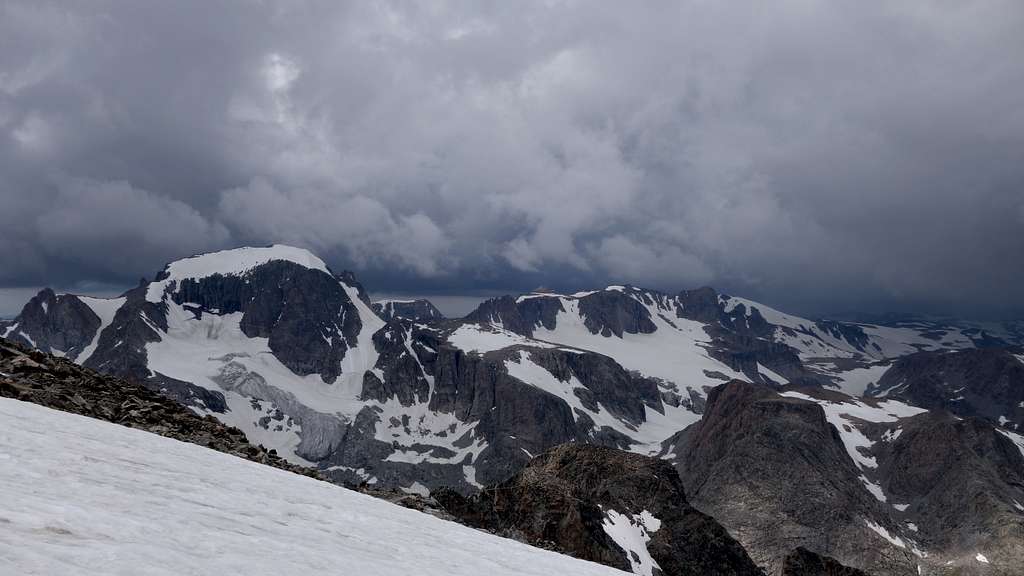
Sunbeam Peak is the 11th highest mountain in the Wind River Range and the 12th highest in Wyoming. Sunbeam consists of a 2 mile long NW to SE trending ridge system, most of which comprises the E wall of the uppermost section of Dinwoody Glacier. The highest point is in the center of this trend. The NW section of the ridge extends between Dinwoody Glacier and Heap Steep Glacier and contains three pinnacles: East Sentinel, Heap Steep and Speck. To the east, a boomerang-shaped ridge descends gently from the summit block to Blaurock Pass. To the SW from the summit, a steeper gendarmed ridge drops to Backpackers Pass (which is actually a col). To the SE, a large, flying buttress extends from near the summit into the valley below Helen Glacier. Routes of all nature have been established.
Approaches
The standard approach is via the Glacier Trail from the Torrey Lakes trailhead. To get there head four miles east of Dubois, turn south from highway 26/287 and follow the improved dirt road (FS #411; passable in cars) eight miles past Trail Lake Ranch to its end. The Glacier Trail is then taken for approximately 21 miles to the Dinwoody moraine.
Alternatively, the area can also be reached from the Elkhart Park trailhead via the route over Bonney Pass. This entails a trek of a similar distance but adds the high crossing of the divide and the complete descent of Dinwoody Glacier. If all you're after is Febbas and you're on a limited time schedule, the tribal outfitter from the Wind River reservation (307-332-7207) can take you up a jeep road and drop you at an eastern extremity of Horse Ridge near the forest service boundary. This fixes you to a strict schedule and will cost in the hundreds after the permits are added.
Route Options
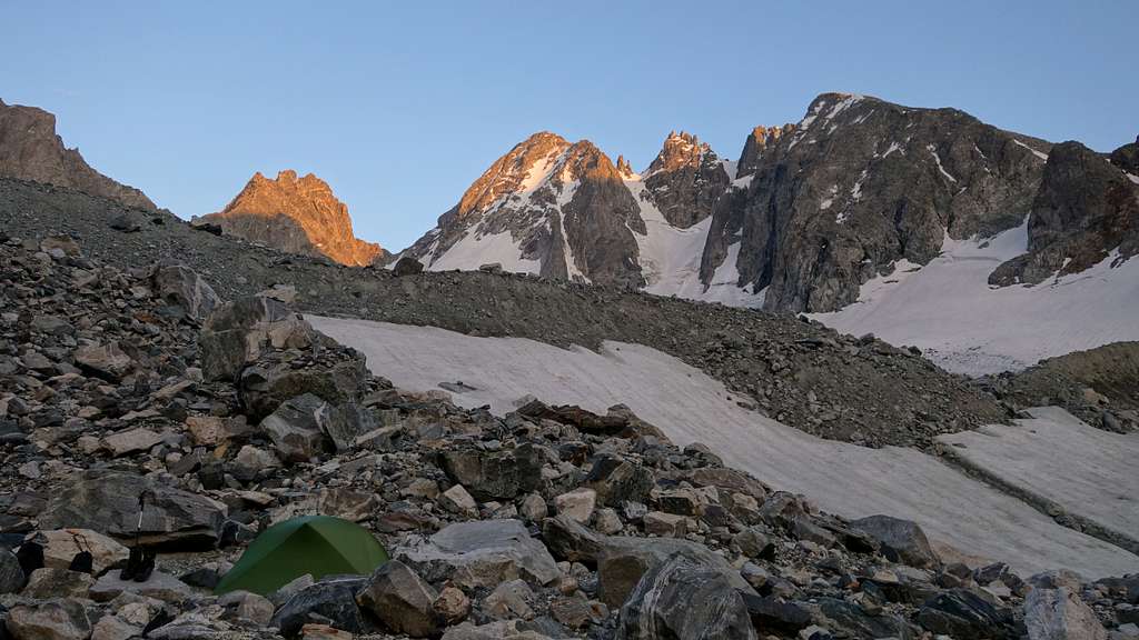
Both routes described below start from a camp on the Dinwoody Moraine.
Southwest Ridge - Class 4
This route choise gives you the bonus of also possibly tagging Turret Peak if you're up for a little more adventure, however the scrambling difficulty is significantly more challenging than the east ridge route described below. From the Dinwoody, hike up the far SE arm of the glacier towards Elsie Col. Pass to the right of a small rocky knob protruding out of the glacier at 11750 feet and aim for the base of a narrow talus gully leading to 12875 foot Backpackers Pass. The 800 foot climb up the boulders is one of the more harrowing talus slopes in all of the Winds, and extreme caution should be taken to avoid getting crushed by any of the large round boulders which seem ready to slide at any time.
From the pass, turn north and scramble the south ridge of Sunbeam, which offers plenty of routefinding challenges to keep the route from turning into low 5th class. Initially, the lower difficulties are bypassed slightly to the right of the crest, and the majority of the ascent is either on, or just off to the east side. There are a few larger steps on the ridge which you'd bypass but never stray too far from the crest. The difficulty should not exceed class 3 for the first 500 feet of the ridge, and exposure is never too dramatic. At about 13320 feet though, the route leave the crest cutting left and the crux of the route is the final headwall leading directly to the summit.
After cutting left off the crest perhaps 30 yards, aim for a weakness in the middle of the headwall above you in the form of a steep class 4 gully. Climb this gully, which nears vertical in a couple short places but with great holds, then make a sharp left traverse on a small exposed ledge that leads to easier terrain off to the left. Continuing directly up the vertical upper part of the headwall above the gully is too hard! After the leftward ledge traverse the difficulty eases to class 3 again for perhaps another 40 feet up and dumps you off right on the summit.
It might also be possible to leave the ridgecrest 50 feet lower than the location mentioned above, and descend a loose class 2 talus gully for 50 feet and cross below a steep rock rib that drops off the headwall to the left of the ascent route described above. Once on the northwest side of this rib, a snow gully can be clibmed to the crest of the upper northwest ridge of the peak, which can then be continued up to the top. This route has some uncertainty to it though, including how steep the snow would be where it crests the NW ridge. This route may or may not be easier than just climbing up the headwall, and since I didn't climb this more indirect route, it's only speculation, but I added it to the topo below with a question mark.
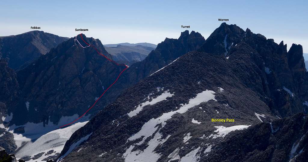
East Ridge - Class 2
This is the least technical route up Sunbeam, and can also allow you to tag Mount Febbas, but you lose the chance to tag Turret Peak if ascending this route. The saddle between Sunbeam and Febbas is called Blaurock Pass, and can be reached relatively easily starting as per the west gully route I described on the Febbas page. When you reach the base of the long scree slope leading to the summit plateau north of Febbas at 11550 feet, continue south and follow scree slopes up another 1200 feet to Blaurock Pass. Expect lots of loose crap. From Blaurock Pass, the east ridge is a stroll on low angle broad slopes, with one spot just before the summit where the ridge narrows and features some exposure, but crossing it is straightforward.
Seasonal Conditions
Summer season in the Wind Rivers is generally July-September with snow lingering on the higher trails into July. A snow storm is traditional between the last week of August and the second week of September. This is normally followed by a dry period with crisp temperatures for 1-4 weeks. On glacier routes, crevasses are hidden in June and begin opening sometime in July. Because the Trail Lake/Torrey trailhead is below 8000', on the dry side of the range (the glaciers above absorb the majority of the storms, causing a rain shadow near Dubois), the trailhead can surprisingly be reached almost year round; the exception being during heavy spring storms. The downside for ski approaches is that several miles must often be hiked before significant snow is reached. An area webcam depicts current conditions. The approach can be heavy with mosquitos June thru July. Water must be carried the first 10 miles of the Glacier Trail.
Map
This map shows both routes up Sunbeam Peak described above with a pink line from a typical camp on the Dinwoody moraine. Combining with the north ridge of Turret Peak is also displayed.
Regulations
The west side approach is managed by the Bridger Wilderness and National Forest. The peak is in the Fitzpatrick Wilderness of Shoshone National Forest. Wilderness regulations apply for camp locations, group size, campfire restrictions and ethics. There are bear requirements for food storage. Minimum-impact camping and travel ethics are increasingly important along the Dinwoody and at Double Lakes. Camping stoves are required, no fires! The Trail Lake trailhead has an undeveloped campground. The Elkhart Park trailhead has developed sites.
Trivia
- Sunbeam was named by original Grand Teton National Park ranger Phil Smith in 1946. It had been climbed by a party including Don Grant and Pauline Clare in 1938.
- Blaurock Pass is named for pioneer Rockies mountaineer Carl Blaurock and connects this peak with Mount Febbas.
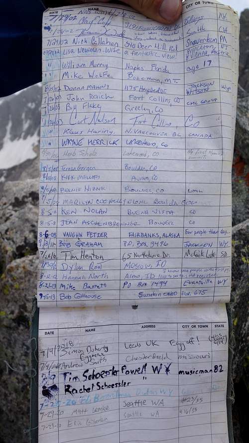
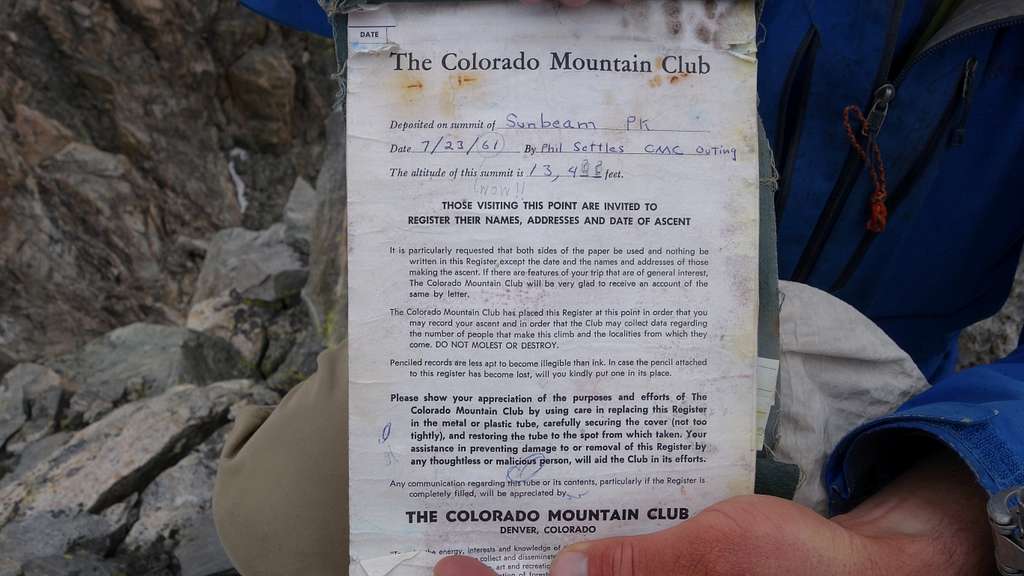
- It's infrequented summit may still have its original register (2020 update: It does...see photos of the register below!)
- The Fitzpatrick Wilderness is named for famed mountain man Tom "Broken Hand" Fitzpatrick.