
|
|
Mountain/Rock |
|---|---|
|
|
31.15492°N / 7.90389°W |
|
|
Hiking, Mountaineering |
|
|
Spring, Fall, Winter |
|
|
8937 ft / 2724 m |
|
|
Overview
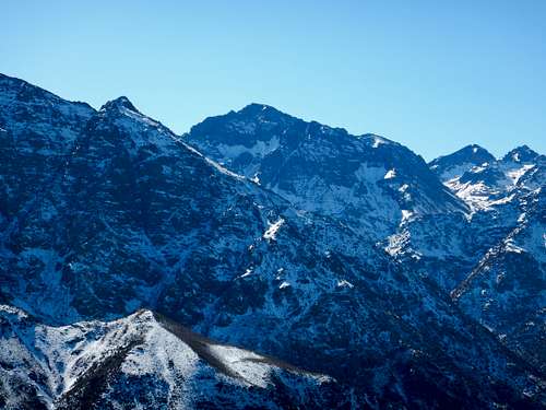
Tamalaroute is a nice mountain east of Imil, the starting point for Jbel Toubkal in the Haute Atlas. Google Maps labels this summit as Aourirt n'Quassif, another possible name.
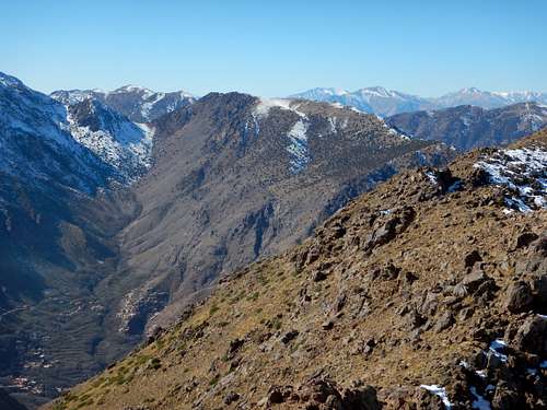
The mountain is an enjoyable hike/scramble and has fine views of the other higher peaks in the Haute Atlas, especially the Jbel Toubkal and Oukaimeden areas.
The mountain is easy to climb and access. A lot of tourist seem to visit Tizi n'Tamarert, which is the pass southeast of the summit, but not nearly as many bother to hike/climb towards the summit. The summit is still climbed fairly frequently though.
This can be a good warm up hike for Toubkal, a wind down hike afterwards, or is even a worthy destination on its own, especially for those that don't have time to climb Toubkal.

Getting There
The first destination is Imil. Perhaps the easiest and most convenient way to get to Imil is to take a Grand Taxi from Marrakech. Grand Taxis leave Marrakech from the Jemaa el-Fnaa bus stop. The trip takes approximately an hour and a half, perhaps a little less.

Routes Overview
The standard route would be to walk or take a high clearence vehicle from Imil to Tizi N'Tamatert, which is a mountain pass located east of Imil. From Imil, there is a both a trail and a road. I walked the trail.
From the pass, a trail heads north towards the mountain. There is both an east summit and a west summit. The west summit is higher and requires a little scrambling to reach.
From Imil, it's a nice 1/2 day trip. There is usually some food, drinks, and refreshments available at Tizi n'Tamatert.

Red Tape
None that I know of.
When to Climb
Summer can be a pretty hot, though an early morning hike would still be pleasant. The altitude assures that it never gets extremely hot here, but the rest of the country can be! Snow can and does fall in winter, but it's usually a pleasant time of year to go. It can be wet in winter as well.
Lodging and Camping
There is plenty of lodging and some camping areas in Imil.
See the link below:
Accomodation in Imil
Mountain Conditions
Imil Weather Forecast
Expect temperatures on the mountain to be around 5C or 10F cooler than in Imil.
Climate for Imil:
| Month | High (° F ) | High (° C) | Low (° F ) | Low (° C) | in. Rain | mm Rain |
| Jan | 53 | 12 | 26 | -3 | 2.44 | 62 |
| Feb | 55 | 13 | 29 | -2 | 2.80 | 71 |
| Mar | 60 | 16 | 33 | 1 | 2.91 | 74 |
| Apr | 66 | 19 | 37 | 3 | 2.83 | 72 |
| May | 72 | 22 | 42 | 6 | 1.54 | 39 |
| Jun | 80 | 27 | 48 | 9 | 0.63 | 16 |
| Jul | 88 | 31 | 53 | 12 | 0.16 | 4 |
| Aug | 87 | 31 | 55 | 13 | 0.20 | 5 |
| Sep | 80 | 27 | 50 | 10 | 0.83 | 21 |
| Oct | 69 | 20 | 43 | 6 | 1.85 | 47 |
| Nov | 59 | 15 | 35 | 2 | 2.72 | 69 |
| Dec | 53 | 11 | 29 | -2 | 2.80 | 71 |