-
 4873 Hits
-
 80.49% Score
-
 12 Votes
|
|
Mountain/Rock |
|---|---|
|
|
44.50409°N / 92.2852°W |
|
|
Pepin |
|
|
Hiking |
|
|
1135 ft / 346 m |
|
|
Overview
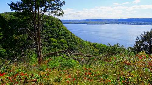
The upper Mississippi River is characterized by many scenic limestone bluffs and small peaks along both sides of the river. One of the most majestic bluffs along the river is Maiden Rock, located just north the village of Stockholm, Wisconsin, and about 6 miles south of the village of Maiden Rock. The bluff is nearly a mile long and is sometimes billed as “400 feet high”. A check of a good topo map will show that while the high point of Maiden Rock is well over 400 feet above the Mississippi river on its western base, the limestone bluffs themselves are a bit under the 400-foot mark.
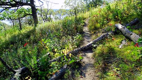
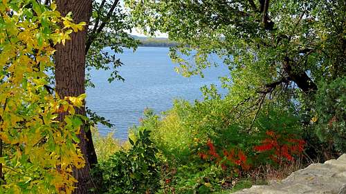
While the bluffs of Maiden Rock are beautiful to view, the overlooks along the edges along the bluff tops also provide some spectacular views of the Mississippi valley below. The forest on and around the bluffs are predominantly red cedar and oak, which also play host to a significant deer population. Shoulder-high weeds grow along the narrow portion (south) of the trail loop, providing opportunities for ticks to work their mischief. There is a small population of timber rattlesnakes here, providing a basis for caution. Along the western base of Maiden Rock is Lake Pepin, a large natural lake on the Mississippi.

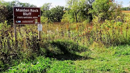
Maiden Rock is the focal point of the 263-acre Maiden Rock State Natural Area (SNA). There are no developed facilities or official trails in this SNA. The Wisconsin DNR made this an official SNA in 2004, hoping to protect the limestone bluffs, which play host to peregrine falcons, hawks, bald eagles, golden eagles, turkey vultures, gyrfalcons, and many migrating bird species. It is an incredible area for bird watchers.
Rock climbers would probably love to establish some climbing routes on these beautiful limestone bluffs. However, that is prohibited here as part of protecting the bluffs and the bird habitat. Perhaps an encouraging note to rock climbers is that several other limestone bluffs along the Mississippi are being developed for climbing. So, the only way to enjoy the view from the top is to use the trail loops at the top.

The story for the naming of the Maiden Rock is similar to stories for other summits around the country, especially those named “Lovers Leap”. According to legend, a young woman from the Dakota tribe jumped off the bluff, rather than to be forced to marry a man other than the one she loved.
Getting There
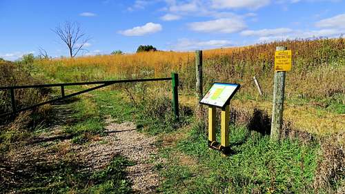
The Maiden Rock State Natural Area is accessible from Highway 35. In the village of Stockholm, turn east on Spring Street, which turns into County Road J. Follow Road J until it intersects with County Road E. Then follow Road E for about 1 mile until you arrive at Long Lane. Turn onto Long Lane and follow it to the end, where you will find a very small parking lot. This is where you will find the trailheads for each end of the trail loop.
Route
There seems to be conflicting route information posted on different sites. Perhaps this is due to changes over the years and some sites not updating their information to reflect trail changes – even though there is no official trail system. What exists as of October, 2021 is a loop trail system, with several little spur trails to overlooks.
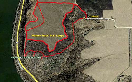
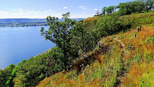
The top of Maiden Rock is predominantly a grassy prairie that is surrounded by forest. The southernmost portion of the trail loops is a narrow winding route through weeds and plants that grow up to shoulder height in places. This is where you will find a few spur trails that go out to overlooks. Access to this trail portion is the trailhead right at the end of the little parking area. A simple hike around the basic loop would be around 1.5 miles, though doing some of the other options will certainly add to that. There is not significant elevation gain or loss on the trail loop, so this should not be much of a factor for most hikers.
The other portion of the trail loop is mowed through the prairie grass and loops to the north out to western tree line, then south and back east to complete the loop. At the southwest corner of the loop, the narrow trail from the south side intersects, allowing access to the best views from the top of Maiden Rock. How often this is mowed is unknown, so be prepared to wade through some tall grass if necessary.
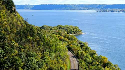
The trail map in this section should give a better idea of how the main trail loop and options work. The overlooks at the southwest part of the trail system provide the best views of the Mississippi valley, with the Great River Road (Highway 35) snaking between the bluff and the river below. Perhaps you will get to see some eagles, falcons or hawks soaring out from the bluffs
Red Tape
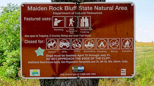
The Maiden Rock State Natural Area has prohibitions against horseback riding, ATV’s, UTV’s, snowmobiles, mountain biking, camping and campfires. Dogs must be leashed April 15 through July 31. Hikers are strongly cautioned against getting too close to the edge of the cliffs.
When to Climb
The area is always open, unless posted otherwise. Please be aware that hunting is allowed in season, so if will be in your best interest to wear lots of bright orange if you choose to hike during one of the hunting seasons. For more info on hunting season dates, click on this link:
Wisconsin Hunting Season Dates
Weather could certainly prove to be a factor in your planning sometimes, since few people like to venture out in hail, lightning or blizzards. You can check the latest weather forecast and conditions at this link:
Maiden Rock Weather Conditions & Forecast
Camping
There is no camping allowed at the Maiden Rock State Natural Area. However, there are camping options nearby:
Stockholm Village Park Campground

Additional Information
Wisconsin DNR Maiden Rock Information