
|
|
Mountain/Rock |
|---|---|
|
|
39.21900°N / 105.468°W |
|
|
12168 ft / 3709 m |
|
|
Lost Creek Wilderness
First, the mountains of the Lost Creek Wilderness submitted here on Summitpost are exclusive to this site. Locating information or any route beta for this area is difficult. Thanks to Jennifer and Gerry Roach's LCW book all of us can view photos and visit these remote summits here on SP.
The Lost Creek Wilderness Area protects nearly 120,000 acres in the Tarryall, Platte River and Kenosha mountain ranges in central Colorado. This relatively new wilderness (designated in 1980) is loaded with hiking, backpacking and climbing possibilities. Typical LCW landscape will consist of mixed and very dense forests, open meadows, small streams; somewhat the norm for Colorado’s high country. Upon first sight, it’s possible the casual climber or mountaineer may not be too impressed with the typical LCW mountain configuration. Dense, tree- laden slopes that frequently lead to tree-covered summits could easily rekindle a forgotten bad memory, a memory that includes your most frightening bushwhacking experience.
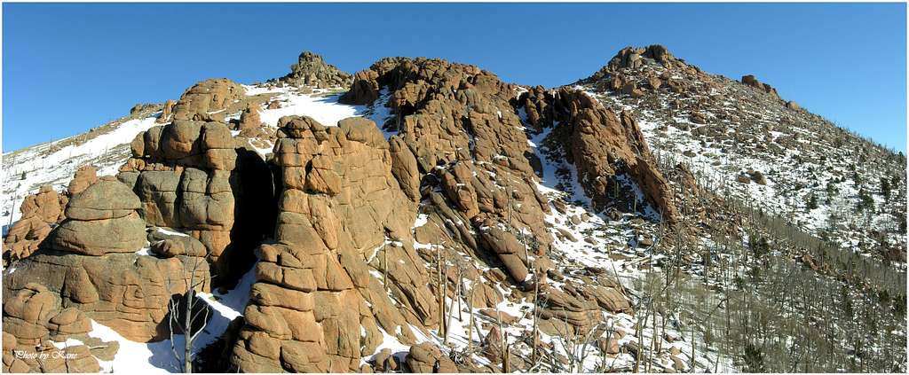
However, despite lacking the grand alpine scenery of other Colorado wilderness areas, one can argue that LCW may be one of the most unique Wildernesses in Colorado. Upon closer inspection the LCW has its own character that no other place in Colorado can match. Character that includes some of the most bizarre rock formations you will ever see. A lot of the LCW is dominated by these incredible rock formations, including massive polished granite domes and towering spires. With elevations ranging from 8,000 to 12,400 feet, many of the mountains here sport huge, wide-open plateaus providing easy hiking and excellent views. Getting to those plateaus is another story.
Tarryall Mountains
Anchoring the Tarryall Mountains to the north is North Tarryall Peak at 11,902-ft, and anchoring the southern end of this range is the lonely South Tarryall Peak at 11,206-ft. This small, 16-mile Colorado mountain range resides within the Lost Creek Wilderness boundary. For viewing purposes the Tarryall Mountains can easily be split into two distinctive sub-ranges; the north and the south.
The north Tarryall's include North Tarryall Peak, Topaz Mountain and Bison Peak. The south Tarryall's include McCurdy Mountain, McCurdy Park, "Tarryall Peak," the "Catamount," Lake Park, "Lake Park Peak," and South Tarryall Peak.
These complex mountains offer an arid climate for Colorado, as well as excellent hiking and climbing during winter and spring. When the mighty Colorado Fourteeners are draped in snow, conditions in the Lost Creek Wilderness usually permit easier hiking and climbing. Because of the lower altitude and the arid climate, summers in the LCW have a reputation for staying hot.
The Tarryall's present some excellent technical climbing in Colorado, you just have to go and find it. The LCW is known for its long approaches, which reserves this area for those that can handle a 2,000-ft, 4-6 mile approach to get to the goods. Do not underestimate the low elevations of the Tarryall Range, these mountains are remote; plus once you're off trail the tree-laden landscape can present a navigational nightmare.
McCurdy Mountain
Having hiked in the nearby Platte River Mountains and the Kenosha Mountains, nothing beats the southern Tarryall's when it comes to the bizarre and beautiful rock formations which provide the visual blueprint of the Lost Creek Wilderness.
For the lack of a better way to submit this sub-range of the Tarryall Mountains to Summitpost; I will submit a Tarryal massif page and this McCurdy Mountain page. Both pages make up the best hiking and climbing in the LCW.
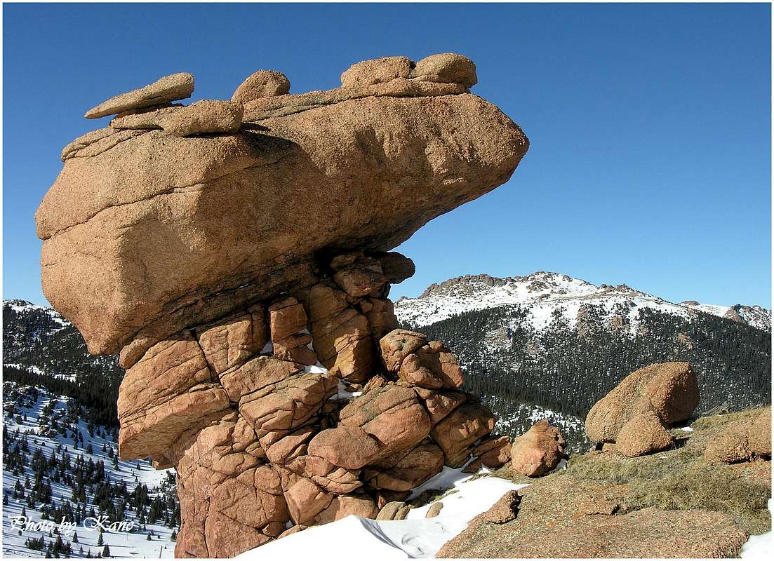
McCurdy is the best mountain in the Lost Creek Wilderness. I finally figured it out. I know it, due to the fact I have climbed this mountain by 5 different routes. Most might think Bison Peak to be the best. I certainly understand that opinion. Well, I've climbed Bison by 4 different routes too. Bison really does have the two best rock formations in the LCW, the monolith and the amptheature. However McCurdy is 3 times the size of Bison. Has 3 times the rock formations and its summit plateau is massive. The clincher; the approach, McCurdy by the Sand Creek route is extremely scenic. Bison's best approach is mostly a slog up through trees.
Different from the Tarryall massif, the McCurdy massif is more expansive, has a lot more open tundra hiking and is more remote. The mountain begins north at McBison Pass at 11,379-ft. This pass is the natural divide that separates Bison Peak from McCurdy Mountain. The McCurdy massif extends south to another pass at 10,740-ft. Ths pass is another natural divide that separates the McCurdy massif from the Tarryall massif. Also, this pass marks the only spot where the Brookside McCurdy Trail meets the Lake Park Trail.
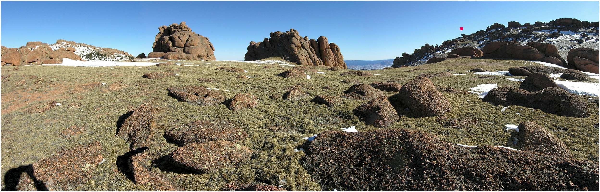
McCurdy Mountain rests 2.1 miles south of Bison Peak within the south Tarryall Range. Both mountains are similar in configuration but both have very distinct character. McCurdy Mountain owns the largest and most expansive summit plateau in the Lost Creek Wilderness. Only Bison Peak compares in open tundra hiking above 12,000-ft. McCurdy is huge; couple that with a rather long approach (via the standard)and there just isn't enough sunlight to explore all of its hidden hideaways.
If McCurdy Mountain was a 14er, perhaps it would be one of Colorado's most popular mountains, but the reality shows that McCurdy is not popular. You have to really want McCurdy to summit, but fortunatly for a select few, this mountain gives much more than it receives.
South Summit and Route
I really enjoyed McCurdy’s south summit. Its only 7 or 8 feet lower than the north summit across the plateau. According to the south summit registry placed by Gerry Roach back in June of 2001, he spent time on the south summit plateau searching for what he called “the seven summits of McCurdy.” Most of these summits are on the south summit area. These summits consist of giant boulders stacked on one another, most too difficult to ascend without a rope. Also, locating the actual true south summit may take time to locate. When you do, expect an easy class 3 climb up a fascinating ramp system to a class 4- inset wide/short crack that leads to the summit.
 |
 |
 |
Point 11,500-ft
Point 11,500 resides about a mile directly south of the summit of McCurdy Mountain. This worthwhile perch comes recommended and is only about a half mile south of the Brookside McCurdy Trail.
The route is simple class 2; attaining the true summit requires an exposed class 2 ramp; about 40-ft of exposure. The rock ramp is only about 6-ft long but there is a boulder above that overhangs most of this ramp, making it a bit awkward to negotiate. I chose to remove my backpack and face inward for the non technical rock ramp. You can probably crawl up the ramp on all fours under the boulder overhang but that seemed toooo weird to me. Whatever you feel more comfortable doing should work.
 |
 |
 |
 |
"Pinpoint Lookout"/Point 10,657-ft
Lost in a sea of rounded domes and rock towers, Point 10,657-ft resides peacefully within the McCurdy Massif. When viewing McCurdy Mountain from the Twin Eagles TH you can’t help but notice this mountains bulk. Upon closer look, the most prominent “needle-like” point, on McCurdy’s western slope is Point 10,657. Guarding the entrance to McCurdy Park, Point 10,657 is a perfect symmetrical cone, complete with a pinpoint, extremely exposed summit. Attaining the actual summit requires 15-ft of "plank walking" or butt scooting, on a 2-ft wide catwalk. This is one of those summits that you have to dangle each leg on opposite sides of the ledge and scoot your way out.
Route
Round Trip-8 miles & 2,100-ft
Starting at the Twin Eagle TH (8,540-ft.), cross Tarryall Creek on a good bridge and hike .03 mile to the Brookside-McCurdy Trail. Left at the register sign-in and follow the trail past some private property at the base of the McCurdy Massif. After 1.4 miles you will intersect the Hankins Pass Trail junction at 8,900 ft.
Continue a mile to the Lost Creek Wilderness Boundary at 9,500-ft. Continue another 1.2 mile as the trail switchbacks up a major drainage that splits the McCurdy Massif from the Tarryall Massif. At 10,385-ft, leave the trail and head west up a wooded slope. Ascend the slope for only 100 vertical feet and from here you can see the tree-laden east ridge of “Pinpoint Lookout.” Descend slightly and hike about a quarter mile up a wooded slope to attain the ridge crest. From here, do a short class 3 scramble through large boulders and lots of down-fall until you reach the summit catwalk. From here, do as you please, you can scoot this section or walk it, depending on the size of your balls.
 |
 |
 |
Current conditions & satillite image
Click here for current weather conditions for Jefferson CO.
Click image to enlarge

Twin Eagles TH-
Twin Eagles TH-8,540-ft
You will need $3.00 to park in the Twin Eagles parking area.
From Denver Colorado, travel Hwy 285 past Aspen Park, Conifer, Pine Junction and Bailey. Continue to Kenosha Pass where you will find the Kenosha Pass Campground. It is only one hour from Denver to Kenosha Pass. Continue to the tiny town of Jefferson and turn left on Park County 77 (Tarryall Road). This road is located directly before Jefferson's only convenient store. Continue 16.9 miles on the convenient paved road to Tarryall Reservoir. Continue passed the Ute Creek Trailhead at 3.3 miles beyond Tarryall Reservoir. Continue another 3 mile to the signed Twin Eagles TH turnoff. There is plenty of parking.
Camping
- There is camping at the Twin Eagles TH, a little after Tarryall Reservoir. Plus you can count on some good spots at the Spruce Grove TH. Camping is $7.00 a night.
- Car camping is easy in the area.
External Links