
|
|
Mountain/Rock |
|---|---|
|
|
39.17660°N / 105.4236°W |
|
|
11780 ft / 3591 m |
|
|
Lost Creek Wilderness Overview
First, the mountains of the Lost Creek Wilderness submitted here on Summitpost are exclusive to this site. Locating information or any route beta for this area is almost nonexistant. I am honored to shed some light on this area and hopefully some of you will visit these far and away summits. Thanks to Jennifer and Gerry Roach's LCW book all of us can view photos and visit these remote summits here on SP.
In 1980, Congress established the Colorado Lost Creek Wilderness area at the request of more comments of Wilderness designation than any other Colorado area. This 120,151-acre wilderness is as diverse as it is spectacular plus, its proximity from Denver Colorado is only two hours.
The Lost Creek Wilderness encompasses three small mountain ranges; the Platte River Mountains, the Kenosha Mountains and the Tarryall Mountains.
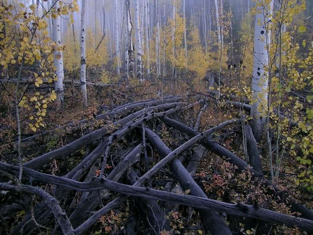
In the summer of 2002 the Hayman Fire destroyed 137,760 acres of Colorado wilderness, including miles of the LCW. The cause of this fire was later determined to be arson. On June 8th, 2002 Colorado's largest wildfire on record, was sparked by an forest ranger claiming she wanted to burn a letter from her husband because she was angry with him. She neglected to actually extinguish the fire. Approximately 40 scorching days later the Hayman Fire was finally controlled. Ironically, her duties that hot summer day were related to "wildfire prevention."
Tarryall Mountains Overview
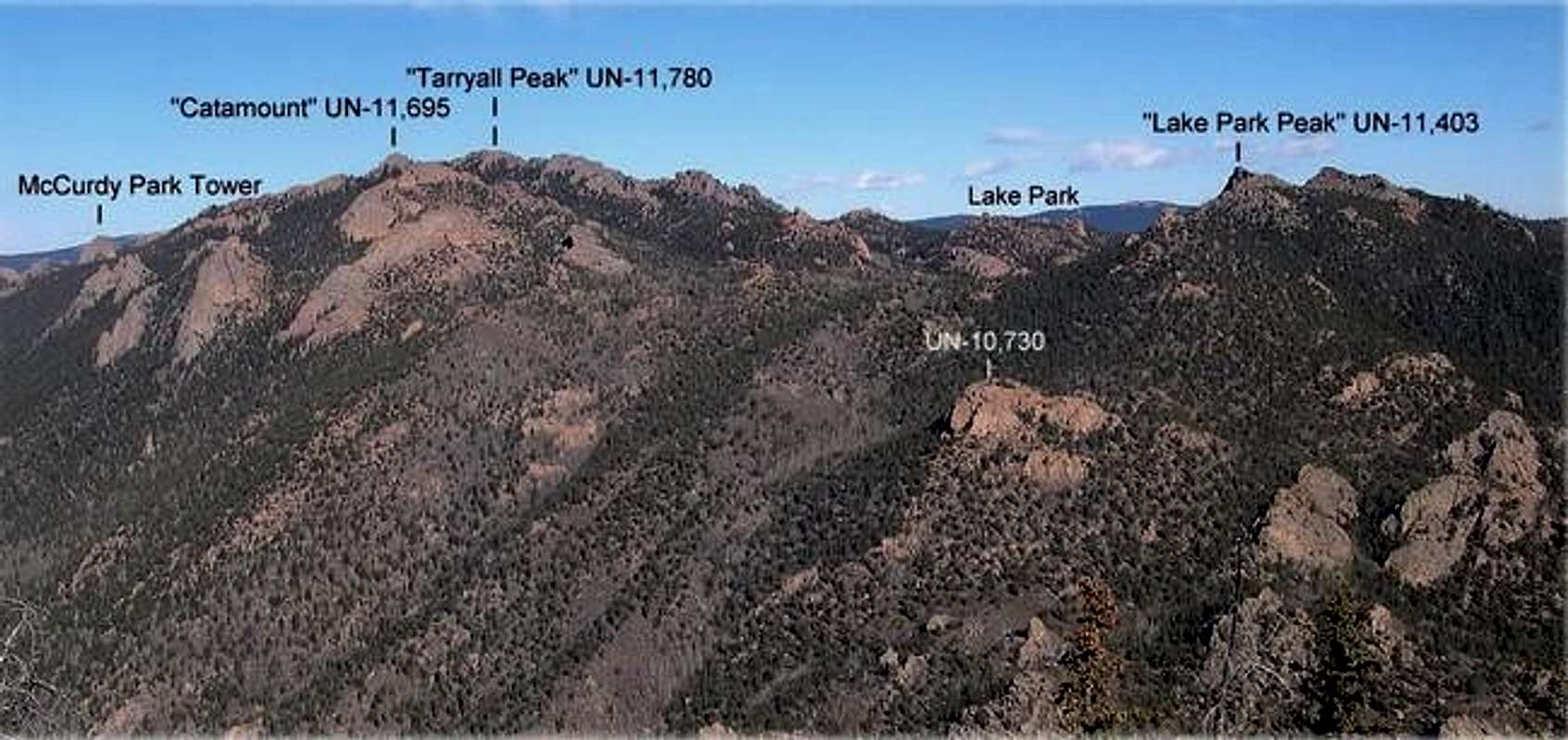
Anchoring the Tarryall Mountains to the north is North Tarryall Peak at 11,902-ft, and anchoring the southern end of this range is the lonely South Tarryall Peak at 11,206-ft. This small, 16-mile Colorado mountain range resides within the Lost Creek Wilderness boundary For viewing purposes the Tarryall Mountains can easily be split into two distinctive sub-ranges; the north and the south.
The north Tarryall's include North Tarryall Peak, Topaz Mountain and Bison Peak. The south Tarryall's include McCurdy Mountain, McCurdy Park, "Tarryall Peak," the "Catamount," Lake Park, "Lake Park Peak," and South Tarryall Peak.
These complex mountains offer an arid climate for Colorado, as well as excellent hiking and climbing during winter and spring. When the mighty Colorado Fourteeners are draped in snow, conditions in the Lost Creek Wilderness usually permit easier hiking and climbing. Because of the lower altitude and the arid climate, summers in the LCW have a reputation for staying hot.
This area also presents some of the best technical climbing in Colorado, you just have to go and find it. The LCW is known for long approaches, which reserves this area for those that can handle a 2,000-ft, 4-6 mile approach to get to the goods. I would be careful not to underestimate the low elevations of the Tarryall Range, for these mountains are remote; plus once you're off trail the tree-laden landscape can present a navigational nightmare.
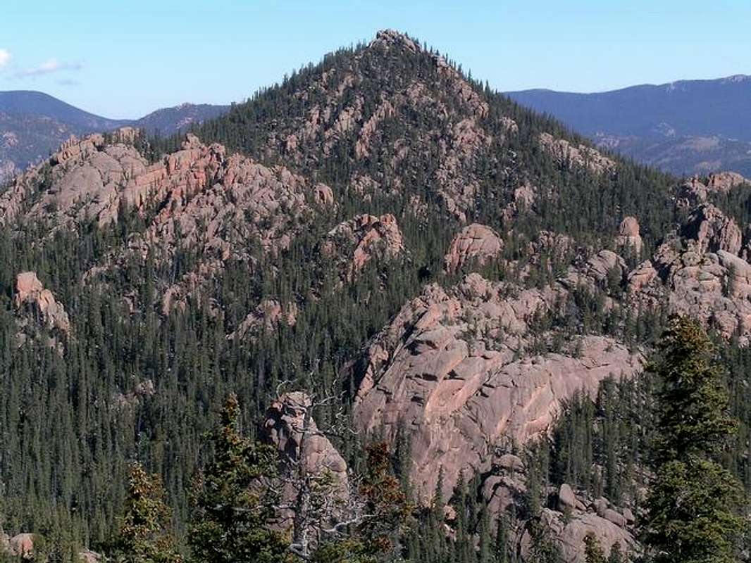
Tarryall Massif
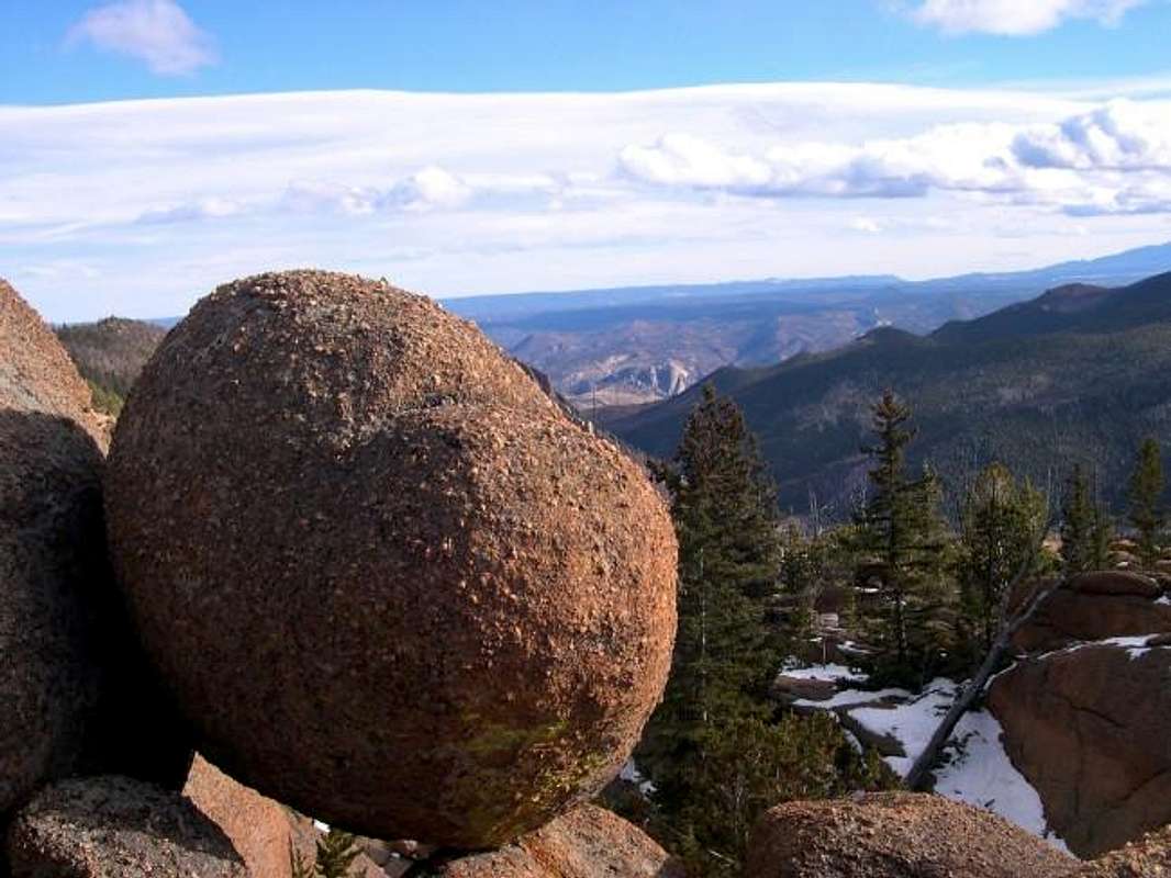
Having hiked in the nearby Platte River Mountains and the Kenosha Mountains, nothing beats the Tarryall's or the South Tarryall's when it comes to the bizarre and beautiful rock formations that provide the visual blueprint of the Lost Creek Wilderness. This land is a world of fascinating rounded domes, craggy spires, rock towers, and rounded knobs.
For the lack of a better way to submit this sub-range of the Tarryall Mountains to Summitpost; I will submit a McCurdy Mountain/Massif page and this Tarryall Massif page.
Similar in look and complexity to the McCurdy Mountain Massif, the Tarryall Massif is another craggy, rock scrambling and climbing mecca. This collection of high points begins at the pass (10,740-ft) that divides McCurdy Mountain from the Tarryall Massif and ends at South Tarryall Mountain. Also, this pass marks the only spot where the Brookside McCurdy Trail meets the Lake Park Trail.
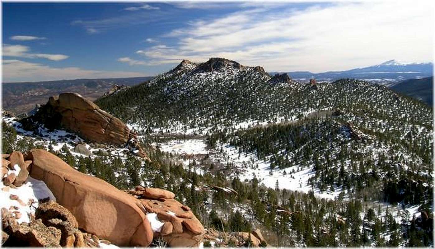
"Tarryall Peak" UN-11,780-ft
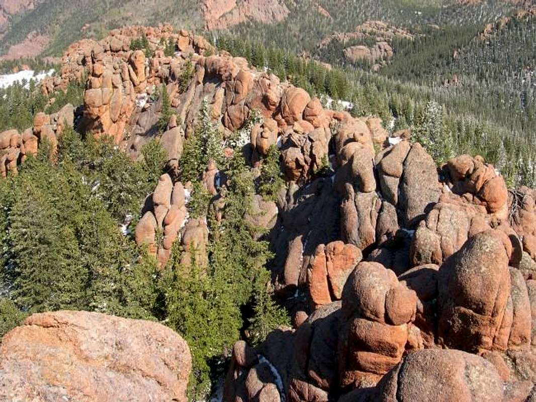
“Tarryall Peak” is not an officially named peak but it is the highest point at 11,780-ft within the Tarryall Massif. This rugged little summit is quite the change of pace if you’re used to the expansive plateaus of Bison and McCurdy. Instead of open tundra hiking, “Tarryall Peak” has steep tree-covered slopes, and the same craggy, granite rock formations that dominate the scenery in the Tarryall's.
“Tarryall Peak” is an easy class 2+ hike from the Lake Park Trail, but a long approach makes this summit a worthy all day endeavor. The view from the summit is very nice, including a dynamic view of Lake Park and a perfect inspiring view of the "Catamount".
Route
Round Trip-11.5 miles & 3,450-ft
Starting at the Twin Eagle TH (8,540-ft.), cross Tarryall Creek on a bridge and hike .03 mile to the Brookside-McCurdy Trail. Go left at the register sign-in and follow the trail as it meanders through some choice private property. Continue 2.4 miles, the trail begins to steepen with switchbacks and continues on to the Lost Creek Wilderness Boundary at 9,500-ft. Continue 1.2 mile north as the trail switchbacks up a major drainage that separates the Tarryall Massif from the McCurdy Massif to a pass at 10,700 ft.
From the pass, go east (right) at the signed Lake Park Trail and continue an ascent up the Tarryall Massif. Follow this easy trail another half mile to an uneventful pass at 11,530-ft. From the pass, leave the trail and hike south up a steep slope through the trees until you reach some towering granite rock formations that make up the summit ramparts of “Tarryall Peak.” Locate and ascend steeper tree-filled, dirt gully that continues south up through the rocks. This gully abruptly ends at some manageable rocks. These rocks require some class 2+ scrambling to ascent to reach the summit.
 |  |  |
"Lake Park Peak" UN-11,403-ft
If you're looking to experience the essence of the Lost Creek Wilderness without a huge all-day commitment, look no further than "Lake Park Peak" (11,403-ft.). The scenic 10.5-mile hike with only 3,100-ft. of vertical is a perfect introduction to this wilderness.
The summit of "Lake Park Peak" is isolated from the rest of the Tarryall Massif. This mountain actually has two summits, the west summit being the slightly higher of the two. The vast Lake Park area separates "Lake Park Peak" from its higher neighbors. The peak has a rough and very jagged south ridge that offers excellent scrambling plus, it's really nice to view. From the summit, you get a comprehensive view of the damage left behind from the Hayman Fire of 2002.
Route
Round Trip-10 miles & 3,050-ft
Starting at the Spruce Grove Trailhead (8,560-ft.) cross-Tarryall Creek on a bridge and continue 2 miles on the well-worn Lizard Rock Trail. After about a mile of relatively no elevation gain the trail swiftly begins to steepen. After the initial 2 miles on the Lizard Rock Trail you will come to a signed trail junction with the Hankins Pass Trail (9,300-ft). Turn east (right) and enter the Lost Creek Wilderness and continue another mile to the 10,020-ft Hankins Pass.
At Hankins Pass, go northwest (left) and locate the Lake Park Trail and continue another mile to pass at 10,900-ft. This pass is the beginning of Lake Park. At this point, leave the comforts of the easy trail and start hiking towards "Lake Park Peak's" knobby south ridge. You can see "Lake Park Peak" resting a half-mile away. From this vantage, you actually see the higher of this peak's two summits. Once you attain the south ridge at 11,100-ft., cross to the south side and pick your way up the rough ridge. Traverse around the right side of the west summit block and ascend north up a v-notch in the ridge. A class 2+ move gets you directly on the ramp that will get you to the summit. This is the higher of the two summits.
I highly recommend Lake Park's east summit as well. It's just a short class 3 scamper away and the views of the Hayman burn area are better from this vantage. Descend the west summit and cross an open saddle. The east summit is more difficult to ascend, but if you locate the steep ramp ascends from right to left it is only class 3.
 |  |  |  |  |
UN-11,328
First, if you’re looking for a summit that sees maybe one or two visitors every few years, look no further than McCurdy Park’s UN-11,328. This very remote cone shaped highpoint is located about 2 miles west of the standard south entrance to McCurdy Park. Like most of the summits in the McCurdy Park rock wonderland, UN-11,328 is crowned with balancing boulders made of the same Pikes Peak granite we LCW lovers have become accustomed to. I discovered this scruffy little mountain while climbing McCurdy Tower and thought it may make a nice place to visit in the future.
Well, the future was Oct. 4th, 2004 and I made the summit via a few interesting class 4 moves. The technical aspect could not have been any more difficult or I would never have continued solo, I did not carry a rope. The summit boulders are precariously placed by the Gods of erosion, rendering a teetering, exposed summit; a summit that doesn’t warrant standing on unless your crazy, but a summit that feels better just sitting on. The route actually climbs up under the summit boulder!
I have submitted a labeled topo map of the area and recommend a loop hike that includes a quick ascent up “Tarryall Peak.” Please refer to the “Tarryall Peak” route submitted on this page.
Loop Route-RT-13 miles and 4,000-ft
The route from “Tarryall Peak” to 11,328 is very doable, however expect a nice bushwhack in between the two peaks, a GPS or a good topo is necessary. There is a tiny meadow that is nestled deep in-between both points that will remind you how far away you are from paved roads.
From the meadow, expect a difficult, but short scramble up UN11,328’s southwest slopes to a tiny saddle that separates 11,328 and a large rock outcropping to the west. From here ascend the west slopes until you reach the summit area consisting of large teetering boulders that are too tough to climb with out a rope.
From the west, you will notice two summits. The south summit is the true summit and doable via some tough class 4 climbing. The north summit basically consists of one large block of rock that looks too tough to ascend without a rope.
Again from the west, look for a notch in the wall of boulders that allows you to cross onto the rougher east side of the summit boulders. If you can’t squeeze through this notch you will have to travel around the summit area to the east. Once through the notch and on the east side, look straight up and locate the summit boulder directly over your head. This boulder balances on some of the rock you must now climb to attain a tiny spot on the north ridge. Climb this class 4 section. Once on the north ridge (if you can call this a ridge) then make a class 3 friction climb up the exposed summit boulder and true summit of UN-11,328.
South Tarryall Peak 11,206-ft
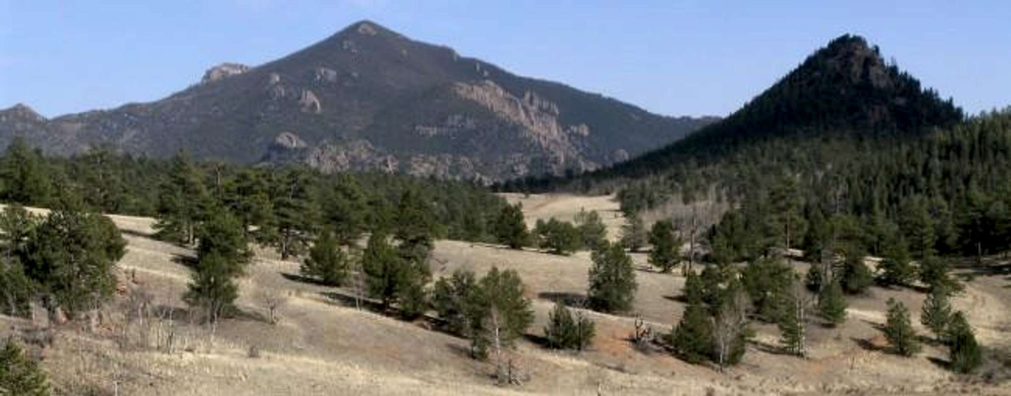
South Tarryall Peak (11,206-ft) marks the southern endpoint of the Tarryall Mountains and its summit is just within the Lost Creek Wilderness boundary. South Tarryall is a singular peak with an official name, and much different in configuration than most of the points listed on this page. South Tarryall is an actual mountain that ascends 1,050-ft from Hankins Pass and 2,800-ft from either the Spruce Grove Trailhead or the Twin Eagles Trailhead; both starting points are virtually equal in distance and vertical gain.
South Tarryall Peak is about 99% covered with trees, the other 1% is a convenient tree less summit. If you want comprehensive view of Bison, McCurdy, Catamount, “Lake Park Peak,” Puma Hills and even Pikes Peak, look no further than South Tarryall’s summit. I guarantee you will be most satisfied.
The easiest route to the summit is South Tarryall’s north ridge, via Hankins Pass. It is a class 2 hike that requires an easy off-trail bushwhack from Hankins Pass to the summit.
Route
Round Trip-8.5 miles & 2,800-ft
Starting at the Spruce Gove Trailhead (8,560-ft.) cross-Tarryall Creek on a bridge and continue 2 miles on the well-worn Lizard Rock Trail. After about a mile of relatively no elevation gain the trail swiftly begins to steepen. After the initial 2 miles on the Lizard Rock Trail you will come to a signed trail junction with the Hankins Pass Trail (9,300-ft). Turn east (right) and enter the Lost Creek Wilderness and continue another mile to the 10,020-ft Hankins Pass.
From Hankins Pass, locate South Tarryall's north ridge. Ascend a moderately steep, tree-laden slope to the broad crest of the north ridge. Continue up this ridge until you reach the wide open summit.
 |  |  |  |  |
UN-10,730-ft
While hiking up to Lake Park via the Hankins Pass Trail, don’t forget to stop by UN-10,730-ft. When viewing UN-10,730 from the west, you can’t help but notice the 300-ft, sheer west face. This daunting, highly technical face of granite swoops up from the west slopes of Lake Park. From the lower slopes of the Tarryall Massif, UN-10,730-ft is as prominent to view as some of the higher points in the area but doesn’t require as much commitment. Just a short distance off the Lake Park Trail, UN- 10,730 provides a short, but fun class three scramble from the east. Enjoy very unique views of South Tarryall Peak and McCurdy Mountain, plus the view east of the Goose Creek Drainage will knock your socks off.Route
Round Trip-8 miles & 2,300-ft
Follow the South Tarryall Peak approach to Hankins Pass and continue another half mile. At this point the Lake Park Trail will bend to the northwest an go away from the west face of UN-10,730. Leave the trail and do a bushwhack up to the base of this tower of rock. From here, traverse around to the east side of UN-10,730 and locate a wide, steep gully littered with large boulders. Ascend this class three gully to the summit.
 |  |  |
Current conditions & satillite image
Click here for current weather conditions for Jefferson CO.Click image to enlarge


Twin Eagles & Spruce Grove-TH
Spruce Grove TH-8,560-ftFrom Denver Colorado travel Hwy 285 past Aspen Park, Conifer, Pine Junction and Bailey. It is only one hour from Denver to Kenosha Pass. Continue to the tiny town of Jefferson and turn left on Park County 77 (Tarryall Road). This road is located directly before Jefferson's only convenient store. Continue 16.9 miles on the convenient paved road to Tarryall Reservoir. Pass the Ute Creek Trailhead, 3.3 miles beyond Tarryall Reservoir. Continue another 4.7 miles to the Spruce Grove Campground turnoff. There is plenty of parking. There is also camping at the trailhead, I believe it is $7.00 a night. It shouldn't take more than two hours to get to this TH.
Twin Eagles TH-8,540-ft
You will need $3.00 to park in the Twin Eagles parking area.
From Denver Colorado, travel Hwy 285 past Aspen Park, Conifer, Pine Junction and Bailey. Continue to Kenosha Pass where you will find the Kenosha Pass Campground. It is only one hour from Denver to Kenosha Pass. Continue to the tiny town of Jefferson and turn left on Park County 77 (Tarryall Road). This road is located directly before Jefferson's only convenient store. Continue 16.9 miles on the convenient paved road to Tarryall Reservoir. Continue passed the Ute Creek Trailhead at 3.3 miles beyond Tarryall Reservoir. Continue another 3 mile to the signed "Twin Eagles TH" turnoff. There is plenty of parking. It shouldn't take more than two hours to get to this TH.
DaveC - Feb 14, 2005 8:51 pm - Hasn't voted
Untitled CommentThere are TONS of great backpack sites in this area, many of which I've enjoyed and, in fact, created. But know, if you're backpacking in, that THERE IS NO WATER IN HERE. Winter, good luck or one-nighters where you haul a night's worth are your options. The topo shows many 'streams' that might run for a week in April, but don't count on it. Bring water, or go in winter with some extra fuel and melt snow. South Park is a dry, dry place indeed.
Now, my rant on paying to park:
Some years ago (fewer than 10), it was free to park here, as it should be. This is federally designated wilderness, technically illegal to run a business on. About 7 or 8 years ago, the parks service turned the operation of certain campgrounds and day use areas over to private companies (in this case, Canyon Enterprises), because the feds didn't find it profitable to operate a campground.
There happens to be a campground here, so out of the blue, they decided, 'hey, we'll charge to park too, even though parkers are using the wilderness only.'
This is BULLSHIT! Ok, I know, it's only 3 bucks, but it's the principle. I will NOT pay to walk public lands. Canyon Enterprises did not make the road in, they sure as hell don't maintain it, and NOTHING is provided for your 3 bucks. Let 'em charge for the campground and day use area-- they do maintain that. But I'll not pay to backpack the wilderness.