
-
 11197 Hits
-
 91.61% Score
-
 36 Votes
|
|
Mountain/Rock |
|---|---|
|
|
47.67318°N / 11.92372°E |
|
|
Hiking |
|
|
Spring, Summer, Fall, Winter |
|
|
5768 ft / 1758 m |
|
|
Overview
 Aiplspitz SW-Ridge in winter
Aiplspitz is a 1758m high mountain in Germany. It belongs to the Bavarian Pre-Alps range. It is one of the so called "Muenchner Hausberge", the day-hiking summits south of Munich the capitol of Bavaria. From top of Aiplspitz you have a nice view to the lowlands of Munich and the other mountains in the Schliersee/Spitzingsee-Area like Rotwand, Hochmiesing, Jaegerkamp and Brecherspitz. Aiplspitz is climbable the whole year round. In summer it is a easy-medium hike (4 main routes) with a rocky final. In winter it is a popular ski-summit in combination with Jaegerkamp and Benzingspitz.
Routes to Aiplspitz in summer:
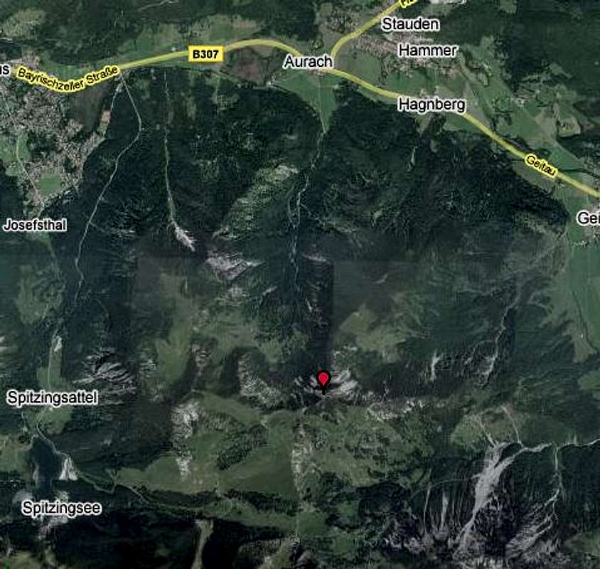
From Aurach: Aurach at B307 near Fischbachau. Follow the track AV641 into the Aurach-valley. After a while you arrive at Benzingberghuette. Continue track AV 641 to the left up to the north-ridge, follow the ridge to the summit of Aiplspitz. It is a 980 meters elevation gain. It takes round about 2 hours.
From Geitau (between Bayrischzell and Fischbachau): At the south end of Geitau are parkings near Rote-Wand-hut. Follow the track AV643 to the south-west. After Geitauer Alm you ascend towards the north ridge of Aiplspitz. Follow the ridge to the highest point. It is a 950 meters elevation gain. It takes 2 hours up to the summit.
From Spitzingsattel #1: You can combine the hike to Aiplspitz with another summit, the Jaegerkamp (1.748m). In this case you follow a steep track to the north-east to the north side of Jaegerkamp. There you arrive at the track AV 642 which leads to the Jaegerbaueralm and to the summit of Jaegerkamp. Follow the track from Jaegerkamp summit to the East. This track doesn´t lead over Benzingspitz, I red about a prohibition of access. The track leads south around the Benzingspitz-summit to Tanzeck and Aiplspitz south-west-ridge. After a little scrambling you reach the summit.
From Spitzingsattel #2: This is the easiest approach. Follow the track AV 643 to Schoenfeldhuette and continue to Obere Schoenfeld Alm. After Schoenfeld Alm the way heads left of a rocky shoulder towards Tanzeck. From Tanzeck scrambling the south-west-ridge up to the summit of Aiplspitz.
Routes to Aiplspitz in winter:
The winter ascent: Parking at Spitzingsee at Taubenstein-cable-car. Follow the ski-piste. After 15min leave the the ski-piste to the left and ascend to the Schoenfeldhuette and Obere Schoenfeld Alm. Continue to Tanzeck. Here you have to make your ski-depot and ascend without ski via the south-west-ridge to the summit of Aiplspitz.
 Aiplspitz from Benzingspitz
 Ski-ascent: View from Schoenfeldhuette
Getting There
Maps and books
- Kompass WK 008 Bayrischzell-Schliersee - 1:35.000 - ISBN: 3-85491-352-4
- Kompass WK 8 Tegernsee-Schliersee-Wendelstein - 1:50.000 - ISBN: 3-85491-010-X
- Heinrich Bauregger - Tegernseer und Schlierseer Berge - ISBN 978-3-7633-4258-7
External Links
- Bayrische Oberlandbahn (railroad)
- Tourist Informations Schliersee and Spitzingsee
- Spitzingsee.com
- WEATHER IN THIS REGION
- DANGER OF AVALANCHES
- WEBCAM OF SCHLIERSEE AND SPITZINGSEE
- Ski-school Spitzingsee