
-
 15934 Hits
-
 86.37% Score
-
 22 Votes
|
|
Mountain/Rock |
|---|---|
|
|
36.17924°N / 115.48974°W |
|
|
Scrambling |
|
|
Spring, Fall, Winter |
|
|
6020 ft / 1835 m |
|
|

By Anya Jingle
Overview
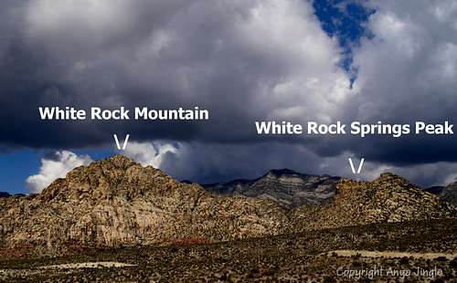
“White Rock Spring Peak,” an unofficially named peak northeast of White Rock Peak in the La Madre Mountain Wilderness Area adjacent to Nevada’s Red Rock Canyon National Conservation Area, is a nice, lightly visited scrambling objective in a stunning desert wilderness setting.
On maps, the peak is Point 5977. However, Point 5977 is not the actual highpoint of WRSP; the real highpoint is just southwest and is the "sharp" peak seen from both the TH and points along the climb. The highpoint crosses the 6000' contour on USGS maps, and I am using 6020', halfway between 6000' and the next contour (6040') as an estimate for the elevation. Captions for this page's photos do indicate that the highpoint is the sharp peak; it is also easy to distinguish by the sheer cliff below it that drops to the saddle connecting WRSP and White Rock Peak.
Do not confuse White Rock Spring Peak with White Rock Peak. The latter is the pyramid-shaped peak almost due west of the parking area (photos on this page differentiate the two peaks). The two peaks are connected by a saddle, and it takes a little route-finding to keep the way between the two safe (see attached route page for traverse)
This peak is nothing to brag about over beers in the evening, but it makes a great short objective if time is limited. During my April 2009 visit to Las Vegas with my 4-year-old son, I was looking for high-quality things to do early in the morning before my son woke up (we were staying with my brothers, so I wasn’t leaving him unattended) or with my son later in the day. Some other SP members recommended this and other peaks; their recommendations were spot on.
By Anya Jingle
Route
From the parking area, get onto the peak’s southeast ridge. This is literally a matter of walking a few yards and stepping onto the rocks. Follow the ridge all the way to the summit. Most of the time, the going is Class 2, but you will probably encounter some Class 3 here and there, especially when closer to the summit. Exposure should not be an issue. Stay as close to the ridgetop as possible; this will increase the difficulty to Class 3, but you will mostly avoid exposure and bushwhacking by doing so. Cairns occasionally mark the way, but it is not essential to look for or follow them.
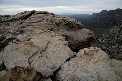
Summit views include many of the famous Zion-like Red Rock peaks, the Spring Mountains, Turtlehead Peak, and the Calico Hills.
Note-- along the way, you will reach a few false summits. If you were paying any attention at all during the drive in and at the trailhead, these false summits will not surprise or discourage you.
RT distance is about 2 miles. Elevation gain is about 1000’.
Getting There
From Charleston Boulevard (Route 159) west of I-215 and Summerlin, turn onto the Scenic Drive in RRCNCA and drive 6 miles to the turnoff for White Rock Spring. Follow the rocky road for a half-mile to the parking area and trailhead.
Red Tape
There is a daily entrance fee of $7 per vehicle (2013). Annual and interagency passes are available (the Interagency Pass, AKA the America the Beautiful Pass, grants access to all federal fee areas for a year).
Hours the Scenic Drive is open:13-Mile Scenic Drive
Note: these hours are subject to change. To be safe and sure, contact the park before visiting.
Hours the Scenic Drive is open:13-Mile Scenic Drive
| November through February | 6 a.m. to 5 p.m. |
| March | 6 a.m. to 7 p.m. |
| April through September | 6 a.m. to 8 p.m. |
| October | 6 a.m. to 7 p.m. |
Note: these hours are subject to change. To be safe and sure, contact the park before visiting.
The BLM (the agency that manages this area) allows dogs in the backcountry. Please keep them leashed and pick up their feces.
Camping
There are no campgrounds off the Scenic Drive in RRCNCA. There is a campground outside it, though; see here for more details. Bivouacs and backcountry camping are permitted, but with permits and restrictions. Use the link at the end of this page to find out more. Camping is not necessary in order to climb White Rock Spring Peak.
External Links
BLM site for RRCNCA

By MoapaPk-- note: the diagram is not for the route described on this page; this map illustrates the discrepancy between the map elevation and the actual highpoint.