
-
 2519 Hits
-
 70.83% Score
-
 1 Votes
|
|
Mountain/Rock |
|---|---|
|
|
38.97049°N / 111.67718°W |
|
|
Hiking |
|
|
Spring, Summer, Fall, Winter |
|
|
8743 ft / 2665 m |
|
|
The major fault line along the Eastern side of Sevier Valley creates a series of mountain ridges that increase in elevation as you travel east from Redmond and Salina, Utah. The second of these forested mountains is Steves Mountain.
Getting There
From Salina, Utah, take US-89 3.5 miles and turn left onto 3500 Redmond Switch Road toward Willow Creek. Continue for 2.4 miles then take a soft right onto Willow Creek Road. Drive for 11 miles. After a clearing, take a hard right (almost a U-turn) onto FR004 (Water Hollow Road). Drive 2.9 miles to the pass where an obvious ATV trailhead is on the right side of the road.
Route
Once at the clearing, follow the ATV trail tracks on the west side of the road. Follow for over a mile to a clearing where the ATV trail crosses a fence and begins traveling south. Once on the south side of the fence, follow the cattle and game trail up the remainder of the peak through the forest.
Round-trip Distance: 3.66 miles
Elevation Gain: 415 feet
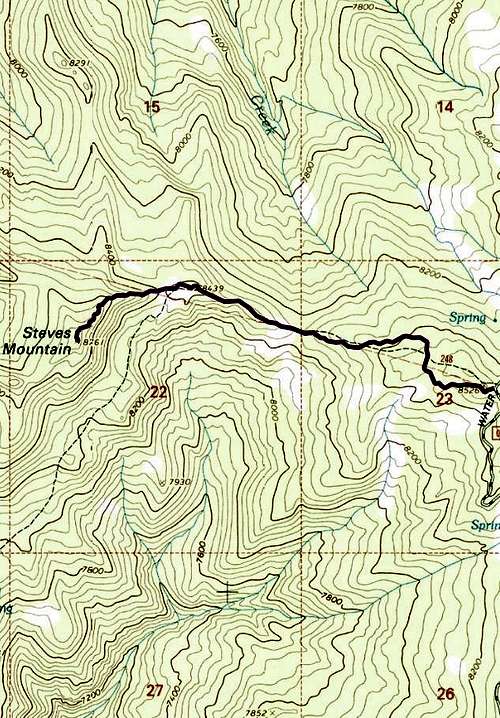
East Ridge Topo
Red Tape
The peak is on land managed by the US Forest Service (Fish Lake National Forest).
When to Climb
Year-round.
Camping
There’s a ton of camping sites along Willow Creek Road and throughout the area if you hope to sleep outside. Otherwise, the small town hotels are not far away.